Saturday, December 31, 2011

Looking Back on a Soggy Vermont Year


The weather the last few weeks has been a roller coaster - temperatures ranging from well above normal to below normal, light snow, hard deep freezes, then warm winds from the south and rain. Yesterday it was in the low 20s and today the dusting of snow on the ground is melting off, though the ground remains frozen. After a couple more warm days, the temperatures are forecast to plunge below zero next week.

The temperature may not be consistent, but one thing has been consistent this year in Vermont. It has been WET. This year has seen the most precipitation Vermont has experienced in a very long time, and in many parts of Vermont this has been the wettest year on record.


IMG_4993.JPG
(above: rain melts holes in snow; a wet end to a very wet year.)


Tuesday, December 27, 2011

Happy Holidays! And, Finally Coloring More Icicles

Happy Holidays!  I hope everyone who is reading this is enjoying their holiday season.  White Christmases are in short supply this year, and New England is no exception - only the higher ground has any significant snow.  The Interior West is socked in with cold and snow, but Vermont is expecting yet another rainy, slushy, icy mess tomorrow. Burlington is expected to pick up enough rain and wet snow to make this the wettest year on record... and the same is true for most of the rest of Vermont.  It's been an eventful year for watershed issues in Vermont, especially during and after Hurricane Irene, but also with heavy spring melt floods in many areas.  However, so far this winter it has not been a good year for one of my favorite side projects - using food coloring to color icicles.  It's been quite cold at times, but the storms have come with warm air and brought mostly rain and few icicles.  Still, I've managed to find a few to color.

IMG_4689.JPG


Thursday, December 22, 2011

December Drenching Brings Ice Cobbles to River

Yesterday was a rainy day, as forecast, and as anticipated (dreaded?) in my last post.  It went about as forecast - some icing and freezing rain in the morning, followed by surprisingly heavy rain, for this time of year at least, that lasted several hours.  The headwaters of the Middlebury River picked up more than half an inch of rain - which would be insubstantial for a summer thunderstorm, but is rather unusual for late December.  Much of the ground was frozen, and the water ran off fast.  The river is running high right now.

As i expected, most of the ice in the river was ripped out.  What I did not expect was to find piles of ice, rounded like river cobbles, laying where the high water left it.


Ice is lighter than liquid water, of course, but quite hard.  I suspect that a combination of melting and smashing against rocks and other ice created these ice chunks... melting alone often accentuates corners rather than smoothing them.


Tuesday, December 20, 2011

Winter Rain on Opposite Coasts

It rained last night.

We have a metal roof and I woke up in the middle of the night to the tapping and plopping of raindrops.  My heart sank a little bit.

Seeing those words on this blog are a bit of a surprise, really.  For most of my 'previous' life in southern California, waking up to December rain would have brought excitement and anticipation.  Essential life-giving water, absent for much of the year, was being poured into the hills and canyons.  In California, rain means green hills that later erupt in a rainbow of flower colors... silent, cobble-strewn creekbeds again filled with the rush of bubbling water, a temporary but impeccable cleanness to the air.  Winter rain in California brings life.

IMG_0976.JPG
After a winter rain on Boney Ridge in southern California, every dip and gully in these rocks is filled with tiny streams.  A few days after the rain, they are again dry.

It's hard to be excited about winter rain in Vermont, though.

IMG_4892.JPG
Snowless fields and overcast skies in Vermont - the crows appreciate the bare mud as their food is not buried in the snow.


Friday, December 16, 2011

Virtual Water Movement: Water Flow in Minecraft and Other Digital Worlds

I've recently become rather addicted to Minecraft, a computer game with a highly modified world of blocks of different types that you can modify and move to build structures and search for resources in an effort to survive.  By day (for about 10 minutes) you can wander the huge, complex, randomly generated world, gather resources, cut and plant trees and crops, and explore, but for the 10 minute night zombies and other monsters emerge and you must retreat to your fortress or go underground to mine for minerals.

When I first started playing this game, my friend told me that I'd probably really enjoy it, except for how the water works.  He's right - modeling water flow is incredibly complex, and it doesn't make sense for a game like this to try to develop a realistic model as it would be a huge drain on computing power.  To someone like me obsessed with water flow, the way water is modeled is silly and a bit frustrating - but not enough so to detract from the enjoyment of the game.

2011-12-15_22.06.37


Monday, December 12, 2011

Beautiful Ice Formations and Snow on the Middlebury River

It's been an unusually warm late fall, but cold weather is still making its way into Vermont, albeit not as quickly as it did last year.  I've been out watching the seasons change and enjoying the patterns made by snow and ice along the river.

IMG_4695.JPG


Thursday, December 8, 2011

Water Updates Across the Planet (and beyond!)

There are lots of things going on right now in the world of water, so I'm going to address a few subjects here.

Much of Vermont got some snow last night - only an inch or two here, more in the mountains and points east.  It's already snowed twice, but both times it quickly melted due to warm temperatures associated with the unusually warm fall.  It's supposed to be much colder now, though not unusually cold, which means the snow should stick around a bit longer.  We have some other chances of light snow in the forecast, but nothing major.  Some small icicles have formed, and I already colored a few of them (see here for colored icicle photos from last year).


My friend Nadine's facebook 'stream' included this interesting article from the Pruned blog about the plan to create a huge clean swimmable area on one branch of Berlin's Spree River.  I am both intrigued and a bit dismayed by this - intrigued by the giant reed filtration system and the idea of getting people back in an urban river, but dismayed to see so much concrete (steps instead of a sand beach?  really?) and apparently few riparian trees.  I'm not sure what is in the space now so maybe there is no net increase of concrete but I'm not sure I am a fan of modifying a river this heavily.  It reminds me a bit of the San Antonio Riverwalk which is very pretty and pleasant but a bit sterile as well...

In any event if the choice is between the giant swimming pool and even larger constructed wetland and a polluted river, I'd take the former, of course.


Finally, the still-active Opportunity rover has found a vein of calcite on Mars!  The only known method for calcite vein formation is liquid water moving through rocks, and this is almost certainly proof of liquid water being present and moving through rocks on Mars in the past.  Calcite veins are common on Earth, where liquid water is of course quite abundant.

Monday, December 5, 2011

Can we Heat Vermont Homes with Invasive Buckthorn?

Vermont has had a warm fall, but winter is coming.  Cold rain and wet snow are in the forecast for this week, with much colder temperatures a near certainty later in the month.  With a weak economy, rising fossil fuel prices, and reductions in federal heating aid, many poor Vermonters are uncertain how they will survive the winter.  Heating oil, used by many to heat their homes, is increasingly expensive and unlikely to get cheaper any time soon.


Streetlight


Meanwhile, many of the forests in Vermont, especially young woodlands that are growing in abandoned fields, have become heavily infested with introduced plants such as glossy buckthorn and common buckthorn.  These invasive plants, which I've talked about before and even made a little video game about, have few or no natural predators.  For this reason it forms dense thickets in open areas and stops trees like maples from returning to these areas.  While the long term effects are uncertain, at the current time we are seeing the formation of thickets of buckthorn with little other plant life.  Removing buckthorn has been shown to allow tree saplings to grow, but removal can be expensive and money is in short supply right now.  There is a movement to reduce the numbers of invasive species by eating them, but buckthorn isn't edible.  Even the beavers don't seem to like it.  Most landowners and land managers don't like it either, but can't afford to remove it themselves.

While testing out a citizen science iPhone app called What's Invasive, I mapped some of the buckthorn in the Champlain Valley area.  This map is by no means complete, and simply represents places I've seen buckthorn when testing the app.  Go to the main website linked above and select the 'Champlain Valley of Vermont' park for more info and photos.

Buckthorn


Friday, December 2, 2011

Logs, Clogs, Shifting Rivers, an Uncertain Future (a sentimental post)

Winter is trying to build in to Vermont and displace the second warmest fall on record.  There is a chance of snow squalls today, perhaps mixed with rain, and tonight the temperatures will plunge to the teens and low 20s.  The battle with the warmth isn't over yet, though.  It will warm up a bit by the end of the weekend, and the forecast is for a VERY SLOW MOVING cold front to pass over the area over the next few days, bringing rain, becoming colder and colder and colder until the rain is BARELY not snow.  Then, we may get a quick inch or two of snow and hopefully the storm will be gone.  Maybe by the time it leaves we will have set the record for the wettest Vermont year on record too.

IMG_4523.JPG IMG_4522.JPGIMG_4520.JPG


Tuesday, November 29, 2011

iNaturalist Mapping Project for Middlebury Area Land Trust

I spent a lot of time working on a new project today, and while it isn't directly related to watershed issues, it is related to technology and natural science so I thought I'd mention it here.

I've posted before about iNaturalist, a website and smartphone app that allows people to upload sightings of different living things found in nature, along with photos and location (located by GPS in the case of smartphones).  There are a lot of neat potential applications for this program, and I decided to set up a project to help gather data on the organisms living around Middlebury, Vermont; especially land managed by the Middlebury Area Land Trust and/or along the Trail Around Middlebury.

This project allows anyone who downloads the iNaturalist app or registers for the website to upload sightings found in the area.  I haven't gotten anyone else involved in this project yet, but I've been doing informal surveys of the vegetation when on solo explores, and have gathered quite a bit of data.  You can see what I've found so far by visiting the project website here.  While you can't view all the data at once, you can view up to 200 occurrences at once at this link, or navigate to a particular location and refresh to get data on a more local level.  Yet, this data is only the tip of the iceberg compared to what is possible using this program.  If I can get a few students at Middlebury College or a few of my friends into using this program, we can gather a nearly unlimited amount of data - and with the photo and GPS capability with smartphones, even people who aren't sure of IDs can participate.

One of the funnest parts of this project is that it is possible to create range maps of different species in the area (and throughout the continent if enough people participate!)  For example, you can see locations of white pine here (this is a very common species - it's really everywhere - but that means I've documented it many times)... you can see the distribution of white oak (a more restricted species in Vermont) here, and you can look for occurrences of invasive Glossy Buckthorn here (though I have also mapped some on What's Invasive and may make a new 'park' for this area also).

I've also included a Google map below.  Note that it is a work in progress - for some reason it is not displaying the occurrences in Battell Woods and I haven't yet figured out why.


View iNaturalist MALT Project in a larger map


Sunday, November 27, 2011

A Few Cold Days in a Warm November on the Middlebury River

This November has been a warmer than average one so far in Vermont.  The temperature has been above 50 on quite a few days, and many overnight lows have been above freezing.  The warm weather wasn't consistent throughout the month, though.  Earlier this week we had a cold snap - with temperatures in the mid teens - followed by several inches of wet snow.

IMG_4413.JPG


Monday, November 21, 2011

A Cold Autumn Visit to the Lower Middlebury River

This November has been an unusually mild one in Vermont so far, but today was an exception.  Despite clear skies, the temperature never made it out of the 30s (and now that the sun has set, it is dropping fast). I decided to take a visit to the lower Middlebury River on my way in to town today, because I'd heard news that the City (make that town) of Middlebury was planning to remove some logs from this section from the river, and as I mentioned in the past, this is not always a good idea.

IMG_4374.JPG

Click below for what I found.


Thursday, November 17, 2011

From Mammatus to Graupel: This November's Wandering Vermont Weather

After a soaking wet and seasonably cold October with a few frosts and some light snow, the onset of November brought an odd weather change to Vermont.  The weather dried out, the sun came out, and warmer than average conditions spread over the state.

IMG_4334.JPG

Above: sun lights up bare deciduous trees along the Middlebury River as it peeks through a gap in the clouds low on the western horizon.  You can't see the river from this photo, but the water level is the lowest it has been since before Irene.

Monday, November 14, 2011

Over The River: Can Waterway-Themed Demonstration Art be Harmful?

If you drive north from Los Angeles on Highway 5, you drive through a remarkable pass.  After meandering upward past the Santa Clara River and hillsides of chaparral, you enter a wide valley, a 'triple-point' of sorts where the Mojave Desert, the chaparral-covered coastal mountains, and the foothills around the Central Valley all come together.  After cresting the Tejon pass at just over 4000 feet of elevation, you plunge into an extremely steep and narrow canyon known as 'The Grapevine' - both because wild grape vines carpet the canyon walls, and because the road itself twists up the canyon like a giant vine.  Approaching the area from the north at night, from the flat Central Valley, the row of taillights ahead appears to ascend, in a wide bend, straight into the sky.

A lot of people funnel through this pass every year, and the passage isn't easy.  The wide Central Valley to the north creates a giant funnel, channeling not only travelers, but also north winds, straight into the pass.  Winds near hurricane force are not uncommon in the winter.  Clouds often form as the air rises over the pass, creating dense fog.  Worst of all, because the pass captures winds and moisture from the colder north, blizzards often rage on the north side of the pass, even when Los Angeles, 50 miles to the south, is sunny and warm.  Meanwhile, in the summer, dry heat from the Mojave Desert and Central Valley build in, leading to temperatures well over 100 degrees, and dozens of overheating cars on any summer day.  Because of the unique climate, blue oaks and buckeye trees normally found further north grow on the north side of the pass, while a few miles to the south Joshua trees are clumped in the gullies.  It is a place of convergence, but not a gentle place.  Even today, passing through The Grapevine can be treacherous, and the pass is known for its road closures and chain-reaction accidents.

The pass is a prominent and important place, and in 1991, two artists - Christo and Jeanne-Claude - decided to fill the pass with giant umbrellas as part of a giant art exhibit.  The effect was visually fascinating, but I can't help but speculate that if the artists thought this was a good idea, they had never tried to drive through this pass during a winter storm.  Sure enough, by late October a windstorm swept into the area.  One of the umbrellas was ripped from the ground and tossed at several people looking at the art exhibit... and a woman was crushed and killed by the umbrella.

Christo is now planning to stretch 7 miles of fabric over the Arkansas River in Colorado.

Tejon Pass
(above - approaching the Tejon Pass from the south.  Clouds banked up against the mountains in winter sometimes warn of a localized blizzard just around the corner)


Friday, November 11, 2011

It's Time To Wear Orange! (Deer Hunting and Slow Water)

In many parts of the country, different seasons brings different fashion styles.  While I was never very good at figuring out how these work in the city, there is one 'fashion season' in rural parts of the country that is very important, if a bit silly looking.

That's right - it's that time of year where most people outside in Vermont are going to start wearing clothes that are brighter orange than the few maple leaves still clinging to the trees.  Rifle season for deer hunting starts tomorrow.  Most people heading out into the woods wear a bright orange hat and/or vest, so they aren't accidentally mistaken for a deer.  If you're heading out for the next few weeks, you should wear a silly orange hat, too.  The last day of rifle season in Vermont is November 27th.  Muzzleloader season in Vermont is December 3 - 11.  Because these guns have a much shorter range than rifles, mistaken identity issues are less likely, but it's still a good idea to wear orange just in case.

Each state has a somewhat different hunting season, so check with your local fish and wildlife department for more info, if you don't already know.

rifle season


See below for more thoughts on deer hunting and watershed health.

Wednesday, November 9, 2011

Vermont Updates: Middlebury River Management Planning Task Force; Lake Champlain Meetings

At last night's Town of Middlebury Select Board meeting (which I did not attend this time), plans were laid out to create a task force to deal with river and flooding issues in East Middlebury.  From the text of the Selectboard Meeting Highlights:


Middlebury River Management Planning Task Force to be Formed. Following the model of the successful river management planning effort in Ripton, the Board endorsed forming a Task Force to develop a plan for on-going management of the Middlebury River as it flows through East Middlebury.

The specialized, focused group could include representatives from the Agency of Natural Resources, the Planning Commission, the Addison County Regional Planning Commission and a river scientist in an effort led by the Town Manager, with technical experts, including engineers with river science experience and hydrologists, retained as needed. The Board emphasized the need to engage residents of East Middlebury in the process by keeping them informed of the group's efforts and soliciting input during the process.

The river management plan is one component of a Hazard Mitigation Plan. The mitigation plan is a pre-requisite for Federal Emergency Management Hazard Mitigation funding, which is the leading source of funding to implement measures to reduce flood hazards.

Town Manager Bill Finger will meet with East Middlebury resident and river scientist Amy Sheldon to develop a strategy for moving ahead with the Task Force and seeking funding for the planning initiative. Pending negotiation of a scope of work, Amy will be retained on a professional basis to serve as the project manager for the effort.

I hope to be involved, at least as a resident of East Middlebury... and also plan to post updates on this blog, which hopefully will provide a balanced, layperson-focused view on what is happening along the river.  In general, I think this is excellent news, and I hope this ends up as an entire-watershed effort and includes working with people in Ripton upstream.  It's great that Amy Sheldon is involved as she is both a resident and a great river scientist... 

The rest of the highlights from the meeting should be posted here soon.

In other Vermont water news, the Poultney Mettowee Natural Resources Conservation District will be holding public meetings about Lake Champlain on November 17th to discuss issues with phosphorous pollution in the lake, and EPA requirements (apparently they have rejected Vermont's current plan).  For more info, see here.  

Monday, November 7, 2011

Downed Trees in the River: Burden or Benefit?

When Irene came raging through Vermont, a lot of trees met their demise.  Some of them were done in by wind, which was fairly strong in some places, but many more were sucked into raging rivers and tossed into matchstick-like piles on sandbars.

IMG_3873.JPG

Scenes like the one above are now common in Vermont, and are particularly common along the Middlebury River near where I live.  Some are glad to see the logs in the river - they can provide habitat for various animals, including trout and the species they eat.  Others are concerned that the logs in the river could cause future problems - causing ice jams or collecting under bridges and causing washouts.


So, who's 'right'?

Thursday, November 3, 2011

Stories Told by the First Snow

Last weekend East Middlebury picked up its first snow - about an inch, but a few miles north it was a dusting and to the south an unseasonable nor'easter raged.  We happened to be just on the edge of the storm.

The light early snow settled on the town and the woods, providing a temporary preview of winter months to come.  In a few hours, most of the snow had melted.  Between the storm's end and the emergence of the sun, however, the snow sat in place for a couple of hours, slowly melting and dripping down from the trees.  At this time, the early season snow told me a lot about how the earth holds the summer's heat long after it is gone from the air.

IMG_4258.JPG


Monday, October 31, 2011

Environmental Action 2011 in Vermont; Thoughts on Gravel Mining in Rivers

As briefly mentioned last week, I was invited to be on a panel at the Environmental Action Conference in Randolph, Vermont last Saturday.  The panel was about river repairs in Vermont after hurricane Irene, and the problems associated with removal of gravel and other sediment from waterways.  The other people on this panel were Louis Porter of the Conservation Law Foundation and Kim Greenwood of the Vermont National Resources Council

The session seemed very short, but I did get to show my video demonstrating the perils of improperly channelized rivers, which was a big hit.  There was time for some good conversation.  In particular, one person wondered whether it were possible to continue 'sustainable' gravel mining at a modest level, similar to what has been done in the past.  I find the idea intriguing, but am very skeptical that it is a good idea.  Unlike the trees in a well-managed woodlot, gravel in a river is not 'growing' in place, but rather is moving downstream during floods.  Removing gravel from one spot can lead to erosion both upstream and downstream, and if gravel removal destroys a house or causes rampant erosion, I would not classify it as sustainable.  There were cases after Irene where sediment was removed to protect structures as a lesser of two evils, but there were also cases where overzealous river work may have actually increased future flood risk.  Now that the storm is gone we need to think long and hard about our next steps.

The idea that gravel mining can reduce flood risk is widespread in the minds of old-time Vermonters, and while I think the balance of evidence leans strongly towards not removing gravel from rivers, there is a lot of validity to the concern that some rivers in Vermont are building up increasing amounts of sediment.  Vermonters know their rivers, and if they notice changes, policymakers should spend the time to listen (as many have).  Excessive sediment in Vermont rivers is almost always linked to problems in the upper watershed.  Improperly built roads channel and speed up water, and small, improperly placed culverts concentrate water and can wash out, leading to massive amounts of erosion.  As many rural areas of Vermont become more populated, and long driveways are built across hillsides, many problems are appearing downstream.  Digging gravel out of a river, however, is the hydrologic equivalent of running into a house fully engulfed in flame and tossing burning wood out of the house - towards other homes.  Anyone who's ever dug a hole in saturated sand can tell you that the hole quickly caves in, and the same happens with river channels cut into gravel or sand.  The real solution is in addressing the 'root' of the problem.  What we need to see is more watershed associations, more awareness in upstream residents, and accountability if someone upstream is causing harm to someone downstream.

Also important:  policymakers are quick to explain why gravel mining is a bad idea, and very willing to use the legal structure to enforce that gravel mining doesn't occur.  What I'd like to see more of is people demonstrating WHY gravel mining is a bad idea.  Most people don't want to hurt others, and won't do something willingly that will endanger someone else... but people are also skeptical of outsiders telling them that their well-established actions are wrong.  I'd like to see more outreach about the issue in Vermont and other areas, and more honest and open dialog.  It's also important to recognizes that there are exceptions to every rule, especially in the case of rivers, and that there were cases after Irene where gravel really did need to be removed from a river.

So, in short, the conference reinforced my belief that efforts to share information with the general public, such as this blog, are important.  

To those people who attended the conference and the session (and the later session about the health of Lake Champlain), thanks so much for attending, participating, listening, and sharing your ideas!  I enjoyed meeting a lot of neat people, and hope to see many of you around Vermont in the future.  I was sad to miss the last part of the conference, but I was quite nervous about driving over two passes on storm-damaged roads in the snow.  Thankfully, I made it home before the storm.  East Middlebury, by the way, only picked up an inch or two of snow.

Friday, October 28, 2011

Major Early Season Snowstorm in Northeastern US?

My most recent Addison County Independent weather blog post was about the computer models used to create weather forecasts, and about how they often were the cause of 'busted' forecasts or last-minute forecast changes.  Specifically, early-week forecasts called for snow in Addison County last night, but by midweek the snow was removed from the forecast in most areas.  In the end, the truth fell somewhere between these two forecast extremes - snow fell in my location but did not 'stick' except on a few especially cold surfaces like the tops of cars and dry logs.  In the mountains, and to the south in Rutland County, more substantial snow fell - several inches in some places.

IMG_4230.JPG
Above: light snow accumulation on some stacked wood in East Middlebury.  For the most part, no measurable snow fell here.


Thursday, October 27, 2011

Plants: Nature's Riverbank Stabilizers


Last week I wrote a post speculating about possible effects of autumn leaves on the flow of rivers and streams.  I noticed that the leaves were forming small dams in slow water and decreasing flow rate, but that during a flood, the leaves would quickly be washed away.  Since that time, I have come across some new research on much more profound effects that trees and other plants have on rivers.  Recent evidence suggests that plants offer much more than just a minor role in affecting river flow.  In fact, when plants like ferns, trees, and grasses colonized the land many millions of years ago, they changed the very nature of how rivers flow.

Monday, October 24, 2011

A Few Fall Slow Water Updates: Cold Weather and River Discussion

October has been warmer than average in Vermont so far, but the month is going to leave us with a chill.  Later this week a cold storm will come blasting through Vermont, and as it leaves the state it may blast us with some snow - one or two slushy inches in the lowlands, several inches in the mountains.  Light snow is not all that unusual for late October, but because it has been warmer than average, it will seem like an abrupt change.  One way or another, the storm will usher us into a time known by some as 'stick season'... once the light snow melts away, the trees will mostly be left bare, a forest of sticks over a layer of leaves, with the only color in the woods provided by the bright orange worn to prevent humans and dogs from being mistaken for deer during hunting season.

IMG_4138.JPG
Above:  This late October color, as seen from Snake Mountain near Virgennes, will soon be stripped from the trees by wind or wet snow.

Speaking of weather, I've been invited to write occasional blog posts about Addison County's weather for the Addison County Independent online page.  You can see my posts here.

I also may be on a panel at the Environmental Action 2011 conference in Randolph, VT this Saturday.  I'd be discussing issues associated with gravel removal from rivers and post-Irene flood repairs, along with Kim Greenwood of VNRC and Louis Porter, the Lake Champlain Lakekeeper.  I hope to have some discussion about how channelization and dredging of rivers is not only an environmental issue but also a threat to safety and a cause of increased flooding in the long term.  I may also talk a bit about my experiences during Irene.  I was very lucky, unlike many others in Vermont, in that I did not experience property damage... but I still experienced a very discomforting afternoon and night where I had to leave our home without warning, and spent time in a shelter wondering if our home was damaged or destroyed. After returning home, I experienced quite a bit of concern when a knee-jerk river channelization effort possibly increased the risk of flood wall failure near my home (the flood wall has since been fixed, but significant issues remain and are undergoing long-term community discussion).  In any event, if you're at the conference, come by - see here for more info.

Monday, October 17, 2011

Autumn on the Middlebury River - Leaves in the Water

Autumn has come to Addison County.  Many of the trees along the Middlebury River are covered in colorful leaves.
IMG_4046.JPG


Some of the leaves find their way into the river, where they float downstream, occasionally finding themselves clogged in 'leaf jams'.  I found myself wondering if this has an effect on water flow.


Wednesday, October 12, 2011

An Illustrated Story of an Oxbow Cut


In the weeks since East Middlebury experienced flooding caused by Tropical Storm Irene, I've been watching a geologic and hydrologic event in progress on the Middlebury River.

When rivers flow through relatively flat areas, they tend to meander.  Meanders grow in size as the river erodes away the 'outside' part of the bend (the side that momentum directs the water towards) and deposits sediment on the 'inside' part of the bend.  Over time, the meanders become more and more convoluted, until the meander grows so large that it cuts back towards itself.  The river then shifts course to 'cut off' the majority of the meander, often leaving a lake or wetland in the abandoned river channel.

The meanders are called oxbows, and are commonly found on natural, slow-moving watercourses of all sorts.  There is a good description of the process here on Wikipedia.

Below is a Google aerial photo of part of the Middlebury River (not the part I have photos and drawings of, but in this area it is easier to make out the river bends).


View Larger Map

You can see many bends including one that has recently cut off, which is at lower right.

With the bend near my home, Irene was able to ALMOST cut through the bend, but didn't quite finish the job.  On the upstream side, the bend cut towards west, and on the downstream side of the bend erosion from water that spilled over the flood plain began eroding backwards and creating a new channel.  The result was a small new branch of the river that cuts across the 'neck' of the bend, with a deep pool in its upstream portion, and a chunk of dirt about 30 feet long that keeps the main force of the river out of its potential new channel... for now.

Below is a sketch I made to illustrate the current status of the cut.  The river flows from the background and bends towards the right, and on the lower left you can see the new river path forming.

oxbow1

Here's a photo of the new channel, taken when the river was still running very high after Irene:

8/29 oxbow post irene, river still high

After several dry days, the water has dropped a lot in the river, but even when the river is low there is a small amount of flow in the channel:

IMG_4531.JPG

Notice all the tree roots in the eroding area.  They are doing an excellent job of holding the soil in place, and since the river has not risen much since Irene, very little additional erosion has occurred here.  I think it will be surprisingly resilient to erosion, but I think the next big flush of water (perhaps the spring thaw) will probably cause most or all of the river to divert down this path.

See here for an album of photos.  I'll be adding more over time.

Here's an illustrated overview of the oxbow cut:

Oxbow2

Here are two more sketches from that day:
IMG_4545.JPG

IMG_4546.JPG

I'll keep watching the oxbow.  Hopefully I can catch it right after it breaks and get good photos of the river in action!  Further forward in time, the abandoned stretch of river will turn into floodplain forest, and will continue to absorb and slow down floodwaters and act as a filter to remove sediment from the river.

Monday, October 10, 2011

Long-Range Winter Weather Outlook: California and Vermont

Despite the warm temperatures in Vermont in the last few days, winter is coming.  The warm weather is a good time to prepare for winter - but what is it we are preparing for?

Long range seasonal weather forecasts are very difficult to make, and often wrong.  Both the most modern computer models and the oldest knowledge of long-time residents (both human and otherwise) can offer us some insight - but in many cases the forecasts still don't end up much more accurate than flipping a coin.  Still, forecasts are fun, and since I'm most familiar with Vermont and southern California, I'll take a look at what some people are saying about these areas, and offer my own thoughts.

As with all long-term forecasts, please don't make plans solely on this post.  Do feel free to share your own thoughts, and next spring I'll check in and see how close these forecasts came to what really happened.

Click below for the forecasts!

Saturday, October 8, 2011

October 10 Meeting to Address Pittsburgh Flooding Issues


Pittsburgh residents, in case you've missed this post in the comments section of my blog, I am re-posting it here.  I won't be able to attend, since I am in Vermont, but you should if you have an interest in this matter (and anyone in the area does!)

Councilman Shields is holding a Community Meeting re: the water/flooding issues in the district. Date: Oct. 10 Time: 6 p.m. Location: Jewish Community Center, Forbes & Murray in Squirrel Hill

If you are unable to attend, please email your comments to: gloria.forouzan@city.pittsburgh.pa.us

Thank you, Gloria Forouzan
Office of Councilman Shields

Wednesday, October 5, 2011

A Winter Sampler: Early Season Winter Storm in California, Freeze in Vermont

It's a beautiful, sunny, blustery day here in Addison County, Vermont.  However, tonight we are going to experience a taste of winter as temperatures are expected to dip into the high 20s.  I won't say more because I may have a post in a different blog about the subject... except that if you still have sensitive plants outside or remnant garden crops to pick, now is the time to do so.

IMG_4234.JPG
Above: fall color near Ripton, Vermont last week.  This week's frost will speed up foliage color change at lower elevations of Vermont.

Meanwhile, a strong early-season winter storm is currently impacting all of California.  On average, the first rains generally come to southern California around Halloween, so this storm is a bit earlier.  Further north the rainy season starts earlier, but the storm has still been stronger than average, with several areas reporting more than an inch of rain.  The Sierras are getting early season snowfall.

The storm seems to be dousing much of Santa Barbara and Ventura counties and Malibu, with over an inch of rain in the last 24 hours in much of these areas.  I expect the Los Angeles area will get much the same or a bit less.  Snow is possible in the mountains.  Here's a map of 24 hour rain totals in the area, but note that it updates automatically so if you click on this a few days after the storm, you should scroll to the bottom of the picture and select '7 day totals' (no other rainfall is likely in this area this week).

Because Southern California gets little or no rain over the summer, the first cold-season storm encounters filthy, oily roads.  The first storm creates VERY slippery conditions on roads, and also unfortunately washes a lot of pollution into local waterways and the ocean.  Rain barrels and rain gardens are especially useful in these conditions - the dry soil will soak up runoff if it gets a chance, and an inch of rain will usually completely fill any rain barrel.  If the rest of the fall is dry, you will need that water for your plants.

Click here for a radar loop of the storm thus far, if I get a chance I'll update later with one that will show later rain as well.

Monday, October 3, 2011

West Coast Post: The Insanity of Lawns

This isn't really relevant to anyone in the US east of the 100th meridian (except Texas) but for those of you who live in dry areas, please watch this video, as shared by Karen Russ on Google+:


So.... we dam up or dry up mountain streams, ship water hundreds of miles, devastate aquifers, kill salmon and render thousands of farmers unemployed for our urban water.  We transport and filter it using an extremely energy-intensive process, then we dump millions of gallons of potable water (something most in the world don't even have access to) all over a 'crop' we don't eat, burn, or feed to animals.  We maintain our lawns using machines that create a great deal of air pollution and consume fossil fuels.  Then, irrigation water and other runoff from lawns ends up in local waterways, bringing with it fertilizers, pesticides, and other pollution.  I remember hearing once that in the summer, most of the water in lower Malibu Creek in California can be tagged via isotope analysis as water from SNOWMELT - snow in the Malibu Creek watershed is a once in a decade event and generally amounts to a dusting to one inch.  The water in the creek is from the Sierras, the Rockies, the southern Cascades... shipped hundreds of miles to end up, polluted, in a creek populated by species that are adapted to dry conditions and can't even use the water.

Lawns are wholly irrational and ridiculous, enact large social and environmental costs, and waste space that could be used for other things - vegetable gardens, micro-habitat patches of native plants, stream restoration, you name it!  Oddly, it's done entirely via an odd form of adult peer pressure (sometimes legally enforced via ridiculous HOA regulations).

I understand it often isn't legally or socially possible to rip out your lawn.  That being the case, we need to address this on a large scale, all at once.  There needs to be a movement to remove all of the lawns of the West, except for shared sports fields and parks.  If we don't do it now, we surely will have to do it later, during the next drought - and we'll end up with a bunch of brown, flammable grass everywhere instead of something better.

If you live in southern California, here's one resource for removing your lawn.  Native plants are one great choice - cacti and succulents, or a vegetable garden, are also excellent choices.  Replacing your lawn with pavement or a 'rock garden' of crushed gravel isn't really much of an improvement, as it creates severe runoff problems.  You want soil... just not lawn.

Out east, there's plenty of water for lawns, but they still require a lot of maintenance and are a cause of water and air pollution.  Consider a vegetable garden, a rain garden, wildflowers, or conversion back to a (managed) forest understory system.  With the latter, you will have wildlife using your yard and can even generate a bit of sustainable firewood and perhaps maple syrup.

Sunday, October 2, 2011

Where the Runoff Goes: East Middlebury Edition

I've noticed some unusual runoff patterns in East Middlebury, VT.  Rather than flowing into drains, or behind houses, runoff water in East Middlebury runs west along the main roads for long distances, often puddling on sidewalks or in the road.  During Hurricane Irene, the water flowing down East Main and Ossie streets was not only fed by local runoff, but by the overflowing Middlebury River as well.  Hopefully that does not happen again, but even when the river is not on the road, small 'creeks' form in places when the rain is heavy.  When it gets below freezing, puddles on the sidewalk and street freeze, causing problems.

The soil in East Middlebury is old sand from a glacial delta as well as newer sand and cobble deposits from the river.  As such, it is very well drained - aside from the river and a few larger streams, you don't see surface runoff in areas of uncompacted soil, even during downpours (an exception is in early spring when the ground is frozen, of course).  Water running off of drainspouts soaks into the ground almost immediately, is filtered as it passes through the sand to an underlying clay layer, and makes it into the river long after the rain has stopped.  Rain gardens on drainspouts aren't really necessary here, but when it comes to water channeled down the road (there are no gutters so it runs right down the road and sidewalk), I can see a lot of value in diversion of this water into small rain gardens or swales.

In trying to figure out where the need is greatest, I went out during two rainy days and documented how the water flows through town.  Here's a Google map of what I found:


View East Middlebury Runoff in a larger map

All of the water flows roughly from east to west (from right to left).  Brown lines represent water running down pavement or sidewalk, the green line is a soft-bottomed ditch that does allow some water to soak in (but would work better if it were a bit wider), and the blue line is a small creek that drains the area north of town.  In a few places the water runs into drains, but mostly these are blocked.

The areas of water flowing down the road are quite substantial.  The 'stream' flowing down Ossie Road is almost a half mile long!  This water flows down the road, picking up pollutants, rushing towards the river, and possibly flooding basements, and at one point branching off and wandering down a driveway (not pictured), instead of being diverted to where it can soak in.  There is clearly the potential to do something better with this water.

I also took lots of pictures.  A map including these pictures is here (unfortunately I don't have an easy way to get them onto Google Earth).  Take a virtual tour!

Wednesday, September 28, 2011

Fish VS. People: A "Red Herring" Washed In by Irene Floods

When talking to people in person and online about Vermont's flooding damage from Irene, I keep coming across an odd concept that seems to have washed in with the floods.  Some people are viewing the skepticism about gravel mining and channelizing rivers as an effort to 'put the interests of fish in front of those of people'.

Obviously the idea of people with such and agenda elicits concerns from residents... no one wants to lose their home in a flood to protect fish habitat.  The thing is... the 'fish/human trade-off' is a myth.  People aren't trying to stop the use of destructive methods of 'flood control' just to help fish.  They are doing so because these obsolete methods don't control floods!  All too often, they involve damaging river ecosystems, while not increasing (and sometimes decreasing) flood safety!

Some people think the mainstream environmental movement has gone awry in considering 'nature' as something that exists at the whim of, and needs protection from, us humans.  I happen to be one of them.  This is an outdated and illogical view.  We don't need to save the rivers from us, nor do we need to over-engineer the rivers to save us from them.  We need to understand the rivers and their watersheds, and use a combination of science, smart engineering, and local knowledge to come up with long-term solutions.  We need to avoid knee-jerk, fear based reactions.  Crews have been doing a great job of fixing infrastructure... an amazing job, in fact.  When it comes to making major modifications to the rivers, though, we need to take a long-term view.

The idea behind channelizing and gravel-mining of rivers is an old one.  The Army Corps of Engineers spent a lot of time in the early 20th century channelizing and dredging rivers, and we are now spending a lot of time dealing with the long term effects of these practices, which include increased sedimentation and erosion, increased flood crest height, and decreased river flow during droughts.  As is so often the case, people were doing what seemed best at the time... but we have learned a lot since that time.  If you became sick, would you want to go to a doctor who would only use medicines and techniques developed before 1930?  Some of these older practices are still very important today, but many have been proven to be ineffective or even harmful.  The same is true with river management practices.  Let's not apply bloodletting leaches and snake-oil treatments to our rivers, just out of stubbornness.  Instead, let's use techniques that acknowledge the effects of the entire watershed and take all we now know into account.

On the flip side, I've also run across a few people who have been advocating rivers who walk into town meetings filled with concerned residents and say things like "I have as much stake in the river as you do - I fish there!".  As someone who very much loves 'my' river (as does everyone I've met in town) and also was threatened by it during flooding, I didn't feel very good when I hear these comments.  I can't imagine how people who don't have as much background in the importance of river conservation feel about these comments, especially people less lucky than I am who spent the week after Irene shoveling mud out of their basements.  YES, we all depend on the rivers, and yes, we should all have our say, since we are all dependent on the health of rivers.  But, please understand that people directly impacted by floods do have a higher stake in the matter, because they are the ones at risk of losing their homes or even their lives when floods occur.  Please do share ideas, speak your mind, and share your thoughts on why some techniques of river 'control' are counterproductive... but please also be respectful of those most impacted by the floods!

Above all, thanks to everyone who cares about our communities and rivers!  There have been some frustrations, but overall, Vermont's response to the Irene floods has been inspirational.  This event will change how we look at and interact with our waterways, and it's looking like, despite a few challenges, the changes will be positive ones.

Monday, September 26, 2011

"Adventures of Junior Raindrop" - Some Things Just Don't Change

Today I found this silly video from the 1940s, shared on Facebook by Julia Gifford:


It's outdated, cheesy, silly, perhaps mildly inappropriate (the rain is starting gang wars?) but also a tiny bit discouraging.  People knew that they were degrading watersheds in the 1940s, and people tried to stop it from happening, but in so many cases it still did.

Things are changing, but very slowly.

Sunday, September 25, 2011

The Perils of River Channelization: A Tin Bucket Simulation

I wanted to create a demonstration on why channelizing and dredging rivers can cause bigger flooding problems than it solves.  But, I don't have a stream table so I had to improvise.  Instead I used a sloped sandy beach, a tin bucket, and a bin with a hole in it.

Disclaimer:  these 'simulations' are in no way scientific... they are heavily biased... very subjective... and can't actually represent any specific river conditions.  But, rivers are incredibly complex and even the best of models often fail to predict river activity.  This at least offers a visual demonstration of some of the concerns around dredging and channelizing rivers.

The setup:
IMG_4178.JPG

The following videos simulate a flood passing through the above channelized river with a bend in it.  A 'flood wall' (in this case made of clay) protects the village of 'West Centerbury'.  The city has channelized the river to 'speed up the flow' in an effort to reduce flood risk.  But, in this case, the channelization directs the flow right into the flood wall, increasing erosion.  Each 'flood' is about 3 small tin buckets worth of water.  Sorry for the shakiness of the video!

(see below)

Thursday, September 22, 2011

Neat Archived Weather Radar Animations from Past Storms

I recently discovered the website Weatherspark.com , when it was posted on Google+ .  This website allows you to obtain very neat graphs of historic weather, average weather, and forecast weather, as well as large maps showing temperatures and radar over large areas.  While Wunderground.com , one of my favorite weather sites, had this information, it is much easier to see on WeatherSpark and also loads faster (I still prefer wunderground.com for its forecasts, conditions from user-established weather stations, and smartphone app).

It's also possible to view archived radar images and conditions (temperature, wind, etc), though the method of finding them is not yet intuitive (I basically had to back-program the URLs).  Here's a few fun radar videos from past storms.  You can scroll around, zoom in and out, or switch between readings such as temperature or wind direction:

Recent severe thunderstorms in southern California (see this blog post).  The coastal storms come in about half way through the animation, so if you want you can skip to those.

Radar and wind speed as Irene moves up the US East Coast .   You can also zoom into Vermont or other areas for more detail.

August flash flooding in Pittsburgh (wait for the second storm cell!) as described in this blog entry.

June 19, 2009 in Pittsburgh, another day when Junction Hollow had sewage-stormwater overflows.

August 10 thunderstorms that caused large hail and flash flooding in East Middlebury, Vermont.  (see here)

July 7, 2011 thunderstorms in Vermont (see this blog post)


May 26, 2011 severe thunderstorms in Vermont (see this blog post)

March 6, 2011 cold front - the radar itself isn't too exciting but watch the temperatures plummet when the cold front passes!  (see also this post).  This storm started as an unseasonably warm rain that we were worried would cause flooding due to the deep snowpack - but it soon turned into a brief ice storm, and then a record-breaking dump of March snow.

These are just a few memorable weather events, and I'm sure I will think of more later.  If you have one you'd like to see, either check out the URL and 'reverse-engineer' it or leave a comment and I'll do it for you.  In the future I'll be able to include these maps with descriptions of weather and flood events.


Radar

Saturday, September 17, 2011

My friend Neahga took these fun animated GIF pictures of the waterfall on Otter Creek in Middlebury.  They only 'work' as animations if displayed at full size, so I've put them behind the cut so they don't clutter up the blog for people looking for other posts.  Click below to see them!

Thursday, September 15, 2011

Wilderness On The Flooded Middlebury River

To some, wilderness is a place 'untouched by man'.  Myself, I don't buy into that idealistic and somewhat problematic idea.  To me, wilderness is something else - wilderness is a place, a state of mind -where the impact and significance of humans is truly seen for the pitifully tiny thing it is.  Our cities and farms and levees and homes are not replacing wilderness, they are simply distracting us from it.

That isn't to say we shouldn't preserve wild, open spaces.  We should.  Nevertheless, I've felt and seen more wilderness on the Burlington, Vermont waterfront during a raging blizzard than I've felt walking trails in Yosemite in the summer.

Lately there's been a controversy in actions the city of Middlebury has taken along the Middlebury River. I started making an upset blog post about it a few days ago, then deleted it, because the situation was too fast moving, and too politically charged, and I was feeling irrational and emotional.  I may post about it in the future, but for now, here's the newspaper article about the controversy.  I'm quoted here, as are others living in East Middlebury.  In any event, I was feeling frustrated with the whole thing, and at the same time others in town had expressed concern about the condition of the river downstream from where this all happened.  So, I set out to explore a new section of the Middlebury River.  I set out, and what I found, was a wilderness.

(click below)

Tuesday, September 13, 2011

Repeated, Preventable Flooding in Pittsburgh's Junction Hollow Neighborhood

While much of the dialog about Pittsburgh's combined sewage-stormwater system centers around sewage discharges into the nearby rivers, for some residents and businesses in the Junction Hollow neighborhood the problem literally strikes much closer to home.  Sewage and stormwater from the Four Mile Run sewer line has, on several occasions, erupted from manhole covers and flooded the neighborhood, dumping raw sewage into basements and flooding streets with many feet of filthy water.

Yes - that's right - raw sewage.  I've spent a bit of time helping clean up flood damage in Vermont and even the silt from Vermont's relatively clean floodwaters becomes a health risk after flooding.  I can't even imagine what it would be like to have this filthy water flowing into my home:


The remarkable video above, taken by local resident Michael Vincent, shows the explosive power experienced when aging combined stormwater-sewage lines are overloaded with water from a summer thunderstorm.  This water is probably coming from the sewer line that channels the runoff - and sewage - from most of the historic Junction Hollow Watershed.

click below for more...


Monday, September 12, 2011

It's Different when it is YOUR Home, and 'YOUR' River.

Update:  This situation is evolving very fast and appears to be much more complex and possibly problematic than I thought.  For this reason I have removed this post for the time being, until it is more clear what is going on.  I'll certainly have updates on the situation in East Middlebury soon.  

Saturday, September 10, 2011

Severe Thunderstorms in Southern California: Mini-Update

Just wanted to make a mini-post about some unusual weather in southern California.  A cutoff low has allowed some severe thunderstorms to form in coastal regions of Orange and Los Angeles counties.  These areas very rarely experience severe thunderstorms, and when they do it is usually associated with winter storms.  These storms are moving from the southeast and have already been associated with some hail in Long Beach.

Picture 16

The main hazard with severe thunderstorms in this part of California would probably be on the roads, especially the freeways.  Check on the radar and consider altering your trip plans if you'd be on a freeway during one of these storms - visibility will be near zero and roads will be very slick, especially since it hasn't rained in a long time.

Unfortunately, most of this rain is falling in the ocean or on concrete so it probably won't get to soak into the ground or provide water to local ecosystems.  There is also some rain up towards Santa Barbara and San Luis Obispo, though, and hopefully this will help increase fuel moisture and decrease fire hazards in this area.  Despite fears to the contrary, these thunderstorms do have significant rain, rather than just dry lightning.

Friday, September 9, 2011

Defunding Stream Gauges: How Much are Lives and Homes Worth?

During a year of some of the worst flooding the United States has ever seen, spanning just about every state except those in severe drought (such as Texas), the US federal government is planning to shut down 376 stream gages due to 'lack of funding'  (Thanks to @wunderground on Twitter for this link).  Apparently, a USGS stream gage costs around $15,700 a year to maintain, a minimal sum when compared to its benefits.  Stream gages allow for accurate flood warnings, that save lives, livestock and property... allow for flood plans to be estimated more accurately... and provide information on water supply during times of drought.

I'm trying not to get into politics too deeply here, since it is a contentious issue and I feel that this is a non-partisan issue and need.  But, when I think about other things our government and economy expend money and resources on, and how tiny a speck the cost of a stream gage is in the grand picture, I am disgusted.  Are human lives, or our homes and everything in them, or our, businesses, crops, and livestock that are our livelihood... not worth $15,700 a year in each of these watersheds?  Are we, the people of the United States, unable or unwilling to demand that our representative government provide cheap and effective services that protect us from loss of life, or is the system so broken that the government is not at all representative of us any more?

There should be many more stream gages being installed, none being removed, and many more rain gages also being added in upper watershed areas.

If our government is unwilling or unable to provide stream and rain gages, I think we need to look into alternatives.  Perhaps a citizen-science type network of people could be assembled who are willing to invest a lesser sum in an automated weather station (probably under $500.00 - perhaps with a tax rebate or grant?) or some form of 'cheap and dirty' stream gage.  Perhaps state governments or private industry could step in (I know I keep mentioning Google, but I know they could be a part of this).  If all else fails, we need a watershed/flood smartphone/computer reporting network (as mentioned before in this blog I am partial to the iNaturalist / whatsinvasive format).  Even a normal webcam aimed at a $3 yardstick in the creek would be better than nothing (though it was just pointed out to me that it would be impossible to see at night, when floods are most dangerous!)

The VTResponse people are doing an amazing job and helping organize flood recovery in Vermont.  Who is going to step forward to protect us from the next flood?  We have great people at the USGS already willing to process the data and inform the authorities of imminent flooding... but they can't do that without having the data in the first place.


Thursday, September 8, 2011

Hurricane Irene Notebook

During Hurricane Irene I recorded some observations in a notebook, along with a few little sketches.  It's not the most detailed journal, and doesn't have all that much art (how do you draw a hurricane?) but I think it's interesting so I am posting it here.  The most notable thing I observed, I think, is the fact that in many areas, such as East Middlebury, the storm didn't seem like THAT big of a deal... and I wrote something to that effect, and then minutes later the fire department came to our door and told us we had to evacuate before the river went down Main Street.    This has been echoed by others in other areas, and speaks to the fact that flash flooding is dependent on what happens upstream, not just what happens where you are.

Also, I noticed an interesting smell when driving through the start of the storm, and have heard elsewhere that others observed the same thing... did anyone else smell anything interesting or out of place during the approach of the storm?

The journal starts in the Berkshires of Massachusetts, and then moves to East Middlebury, Vermont.

Irene Notebook 1

Irene Notebook 2

Irene Notebook 3

Irene Notebook 4


Monday, September 5, 2011

Food Coloring in Water: A Break from Irene

I've mostly been using this blog to give updates on Irene, and before that information on Pittsburgh's recent flash flood.  But, I figured that people are weary of only reading bad news and might like to see a project I've been working on instead.

Long-time readers of this blog (if there are any) as well as any real life friends in Vermont will remember how excited I got about coloring icicles, and later coloring small urban snowmelt streams, to help show people the path of urban runoff.  Lately, I found a bunch of food coloring on sale, and decided to see if I could find water movement in unexpected places.

Because of diffusion, dye will move even through perfectly still water; the slight differences in the density of dye may also cause it to move.  For the most part, though, the swirls and patterns created when food dye is placed in water are caused by otherwise invisible currents in the water.

IMG_3737.JPG


Sunday, September 4, 2011

Technology-Based Irene Relief: Thanks VTResponse, Google, and Ushahidi

One of the small bright spots of Irene hitting Vermont have been the innovative ways people have found to use technology to help out.

The group that is getting the most attention, and rightfully so, is VTResponse.  This group, created by UVM student Sarah Waterman, has been helping connect volunteers with people who need help since shortly after the storm left.  This group was the inspiration for us going to help in Brandon twice, and has brought help to a lot of people.  There is also an unrelated website devoted to collecting donations for small businesses called VTIreneFund.  I hope we see more things like this in the future, too.

I have a soft spot for  Google because I love the Google Maps and Google Earth products, which I use to make watershed maps like these.  Google has helped out by creating this interactive map of road closures and other problems.  It has been incredibly helpful.  It isn't perfect, as there has been some incorrect or outdated information, but this seems to be due to the difficulty of keeping up with Irene news, and a feature of the information source itself, not of Google.  There is also crowd-sourced information (see below).  In any event, I just think it is really neat that Google, a huge corporation with no offices in Vermont, has gone out of their way to help out like this.

Ushahidi is an app that allows for crowdsourced collection of info, especially during and after disasters.  This app and associated website is the source for some of the info found on the Google Vermont Irene map.  There is also an effort to map where flooding happened.  I tried out Ushahidi on my iPhone last winter and it didn't seem to work well, so I deleted it and forgot about it.  Now, it seems like the bugs have been worked out and the program is seeing more extensive use, so I'm going to give it a try again.

There have been a lot of groups using technology to help out, so if I missed you, don't feel bad, but leave a comment here instead.


On a less rosy note, Vermont residents should be aware that a storm containing moisture from Tropical Storm Lee will move through the state later today and Monday.  There could be some flash flooding, especially in areas of unstable, eroded ground left over from Irene.  Be very aware when using newly-repaired 'stopgap' roadways as these may be more vulnerable to washing out again.  Keep an eye on the weather, evacuate if you see flooding that threatens your home, and just generally be safe!  Hopefully this moves through fast and cleanup can continue.

Saturday, September 3, 2011

Vermont Post-Irene Flooding Mini-Update

The National Weather Service has issued a flood warning for all of Vermont.  Worst potential for flooding will be Sunday night into Monday, but scattered strong to severe thunderstorms could cause flooding sooner.

This would normally only be enough rain to cause localized flash flooding.  But most of the highway/bridge repairs around Vermont consist of soft, loose gravel and are not able to even withstand moderately high water.

If you live in an area that had become an 'island' or almost became an 'island' during Irene, and you want to go home, BUY LOTS OF SUPPLIES!  Be ready to be alone there again.  Or, stay with a friend in Burlington or somewhere else safe.

I think this flooding will be worse on mountain streams and small rivers, and less severe in places like the Winooski River and Otter Creek.  There are no guarantees though.  Please be safe!

Friday, September 2, 2011

Less Talk, More Rock (lined erosion areas) - Brandon, Vermont Irene Update

Brand Aid

Yesterday I felt like I was doing a bit too much typing and talking and not being helpful enough, so I went with two friends to Brandon to see if any help was needed.  We were sent to a rural road where a wood shop owner asked us to help direct cars away from undercut sections of road.  The flood had heavily eroded this small country road, but there was a lot of traffic as people tried to find their way around.  Apparently Brandon was totally out of traffic cones.  So, this meant that we had to use what was available - rocks and flood debris - to mark off where the road was hazardous.

IMG_3899.JPG

(more below on Brandon and Addison County)


Wednesday, August 31, 2011

Preparing for or Preventing the Next Vermont Flood

Irene has come and gone from Vermont, but we are going to be dealing with her effects for a long time.  Homes and businesses are destroyed, roads and bridges washed out, and people displaced and understandably concerned.

Irene was an 'almost-worst-case-scenario' for Vermont, and hopefully we won't see anything like it again in our lifetimes.  However, floods are a part of Vermont life and we will certainly face other damaging floods in the years to come.  While we can't completely stop them, there are things we can do to decrease their intensity and increase our preparedness when they do occur.

In some ways, reducing flooding in Vermont is harder than in many areas.  Unlike Pittsburgh, with highly urbanized, modified watersheds, or California, with its channelized streams and massive habitat loss, Vermont is a mainly rural state with vast, healthy forests and small towns.  Still, there is much we can do to reduce risk and impact of floods.

This post includes some ideas I have about how to reduce flooding risk, prepare for floods, and better cope when they do occur.  If you think these ideas make sense, please share this with others.  If you think they don't make sense, leave a comment and tell me why.  The most important thing right now, aside from cleanup and repairs, is looking ahead together as a state to make sure nothing like this happens again.

Below are my ideas, in somewhat random order:


Tuesday, August 30, 2011

Middlebury River After Irene

After learning that East Middlebury largely escaped serious damage from the Irene floods, i set out to check on what had happened along the river.  Like most areas of Vermont, the water rose higher than any of the residents I talked to remembered (I'm not sure how this area fared in the floods of the late 1920s).  It seems that this was at least a '50 year flood' if not a '100 year flood'.  (Note that these floods are named by their probability of occurrence, ie: a 100 year flood has a 1 in 100 year chance of happening.  They don't necessarily happen every 100 years).

East Middlebury lies on a glacial delta that formed when glacial Lake Vermont filled the Champlain Valley.  The river emerges from the mountains and changes from a steep, gorge-confined river, to a meandering, slow stream as it passes through East Middlebury.  In the process, it drops sediment from the mountains.  Larger rocks are dropped near the gorge, gravel and sand carried further, silt deposited in slow-water areas, and clay carried out of the area (and often all the way to Lake Champlain).

Anyway, back to Irene... the storm created a historic flood that had big effects on the river.  But, in the rockbound gorge, very little changed.  The gorge was at least in part cut when the river was much larger than now due to glacial dams diverting the New Haven River down its course as well.  So, even this major flood is smaller than the floods that carved the gorge.  While some rocks shifted, the river's course did not.  It takes thousands of floods like this to carve a gorge like that, and it doesn't usually change very fast.  See the comments on this post for more info on the glacial history of the area courtesy of Chris.

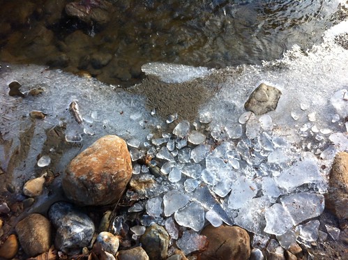
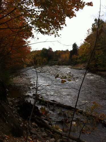
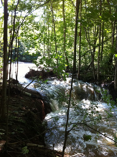
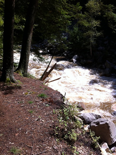
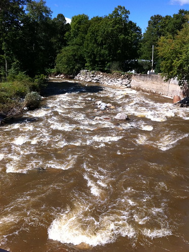
The river was RAGING the day after the Irene floods.  I very carefully took this picture, making sure to avoid the banks of the river, which could have been eroded by the floods.  If I fell into this, I'd be done for!

IMG_3867.JPG

At the base of the mountains, the river passes through this even narrower gorge under the Highway 125 bridge:

IMG_3865.JPG

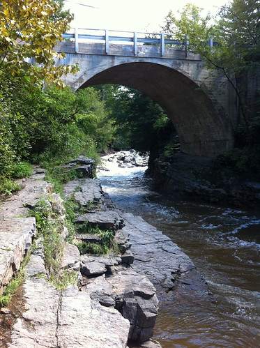
Sometimes we go swimming here, but not today.  (Note: After Irene, do NOT dive into swimming holes, even in areas that have always been safe, without checking if it is still OK first.  Irene's flood moved some enormous boulders and changed where sand and gravel bars are located... previously safe areas may be deadly to divers now.)

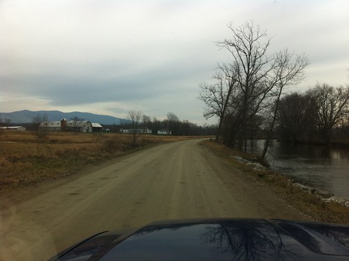
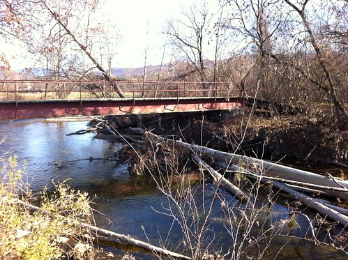
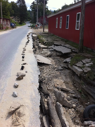
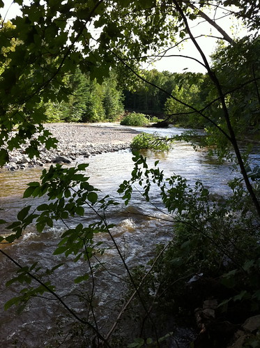
After leaving the gorge, the river slows down a bit and passes through town.  Here's the river from Grist Mill Road, looking downstream.  As the name implies, there was once a mill here.  You can see the features in place to protect the town from the river.  They have worked well for many years, but this flood was too much for them.  Upstream from here, the river jumped its banks and ran down Highway 125 for a while, flooding basements and eroding driveways.  Note that the river is still rather confined by its banks and these levees.

IMG_3862.JPG

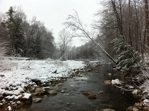
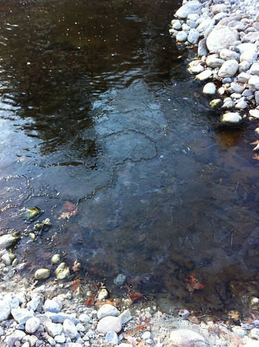
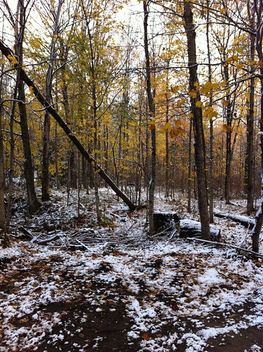
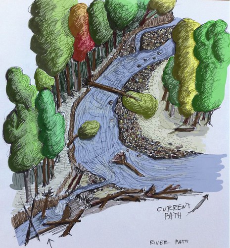
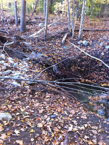
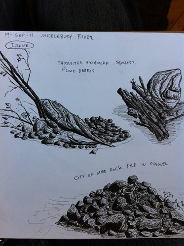
Between Grist Mill Road and Route 7, the Middlebury River drops a lot of sediment.  Its course begins to wander, and sycamores and cottonwoods, rare in Vermont, line its banks.  This part of the river is very dynamic, and changed a LOT during the floods.

IMG_3870.JPG

IMG_3871.JPG

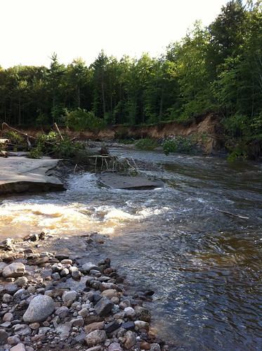
Both these areas are almost unrecognizable since the river has changed so much.

IMG_3873.JPG

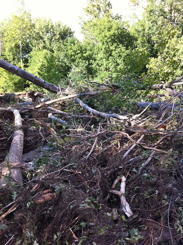
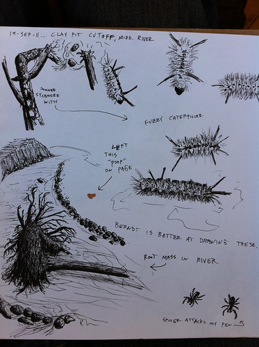
Trees from upstream are laying in piles everywhere.  This looks like a lot of destruction, but trees in rivers provide habitats for lots of creatures, including trout and the species they eat.

IMG_3858.JPG

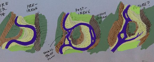
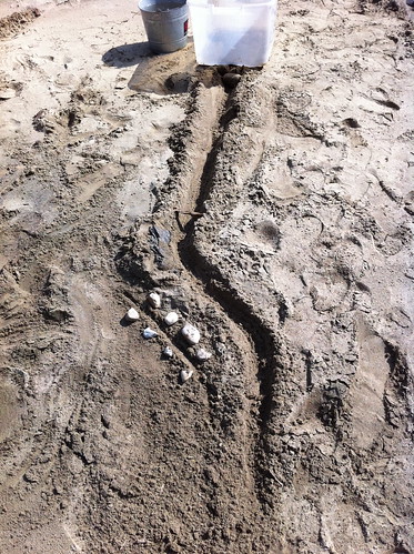
Above, a side channel of the river erodes backwards towards the main stream.  Eventually this channel may reach the main channel and 'steal' its water, causing the river to shift course.  In this case, this happening would not endanger structures since it's in the undeveloped flood plain.  The old river channel would become a wetland, then gradually fill in with cottonwood and sycamore trees.  Over the thousands of years since the last Ice Age, this process has created a dynamic, diverse ecosystem along the river.  The Middlebury Area Land Trust has obtained a conservation easement along part of the river in this section, which will allow the river to continue unrestrainted in its wanders.

Downstream from Highway 7, the Middlebury River has dropped most of its heavy sediment, and it slows down and meanders extensively.  I didn't visit this section yesterday, because it was more heavily impacted by flooding and I didn't want to get in the way of residents dealing with flood damage.  I'll visit the lower section of the river at a later date and see how it fared during the floods.

Here's a Google map of the Middlebury River at the gorge:


View Larger Map

Note: please respect private property rights and don't try to access the river through private property.  There are places where you can see the river near the 125 and 7 bridges.  The MALT parcel is not yet developed for public access, but may be in the future.  This river is very sensitive to rainfall and rises fast during floods, so stay away from the river, especially in the gorge, during and after heavy rains!