During a year of some of the worst flooding the United States has ever seen, spanning just about every state except those in severe drought (such as Texas), the US federal government is planning to shut down 376 stream gages due to 'lack of funding' (Thanks to @wunderground on Twitter for this link). Apparently, a USGS stream gage costs around $15,700 a year to maintain, a minimal sum when compared to its benefits. Stream gages allow for accurate flood warnings, that save lives, livestock and property... allow for flood plans to be estimated more accurately... and provide information on water supply during times of drought.
I'm trying not to get into politics too deeply here, since it is a contentious issue and I feel that this is a non-partisan issue and need. But, when I think about other things our government and economy expend money and resources on, and how tiny a speck the cost of a stream gage is in the grand picture, I am disgusted. Are human lives, or our homes and everything in them, or our, businesses, crops, and livestock that are our livelihood... not worth $15,700 a year in each of these watersheds? Are we, the people of the United States, unable or unwilling to demand that our representative government provide cheap and effective services that protect us from loss of life, or is the system so broken that the government is not at all representative of us any more?
There should be many more stream gages being installed, none being removed, and many more rain gages also being added in upper watershed areas.
If our government is unwilling or unable to provide stream and rain gages, I think we need to look into alternatives. Perhaps a citizen-science type network of people could be assembled who are willing to invest a lesser sum in an automated weather station (probably under $500.00 - perhaps with a tax rebate or grant?) or some form of 'cheap and dirty' stream gage. Perhaps state governments or private industry could step in (I know I keep mentioning Google, but I know they could be a part of this). If all else fails, we need a watershed/flood smartphone/computer reporting network (as mentioned before in this blog I am partial to the iNaturalist / whatsinvasive format). Even a normal webcam aimed at a $3 yardstick in the creek would be better than nothing (though it was just pointed out to me that it would be impossible to see at night, when floods are most dangerous!)
The VTResponse people are doing an amazing job and helping organize flood recovery in Vermont. Who is going to step forward to protect us from the next flood? We have great people at the USGS already willing to process the data and inform the authorities of imminent flooding... but they can't do that without having the data in the first place.

Stories about the ways water moves through natural and human-constructed landscapes... what we can learn from it and how we can use old and new ideas to understand, appreciate, and sustainably use this resource.
Showing posts with label Storms. Show all posts
Showing posts with label Storms. Show all posts
Friday, September 9, 2011
Wednesday, August 31, 2011
Preparing for or Preventing the Next Vermont Flood
Irene has come and gone from Vermont, but we are going to be dealing with her effects for a long time. Homes and businesses are destroyed, roads and bridges washed out, and people displaced and understandably concerned.
Irene was an 'almost-worst-case-scenario' for Vermont, and hopefully we won't see anything like it again in our lifetimes. However, floods are a part of Vermont life and we will certainly face other damaging floods in the years to come. While we can't completely stop them, there are things we can do to decrease their intensity and increase our preparedness when they do occur.
In some ways, reducing flooding in Vermont is harder than in many areas. Unlike Pittsburgh, with highly urbanized, modified watersheds, or California, with its channelized streams and massive habitat loss, Vermont is a mainly rural state with vast, healthy forests and small towns. Still, there is much we can do to reduce risk and impact of floods.
This post includes some ideas I have about how to reduce flooding risk, prepare for floods, and better cope when they do occur. If you think these ideas make sense, please share this with others. If you think they don't make sense, leave a comment and tell me why. The most important thing right now, aside from cleanup and repairs, is looking ahead together as a state to make sure nothing like this happens again.
Below are my ideas, in somewhat random order:
Monday, July 11, 2011
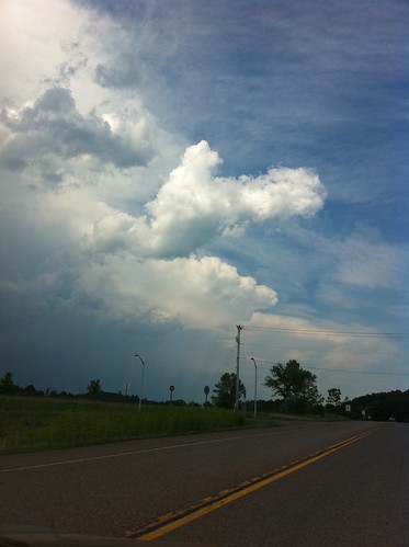
July 6 Severe Thunderstorms near Burlington, Vermont
On July 6, another line of severe thunderstorms passed through Vermont, causing wind damage in many areas. I had the opportunity to get a very good view of these storms, because we ended up driving through the line in Charlotte, Vermont.
Sunday, December 19, 2010
Flooding in Southern California
A series of very powerful and wet storms are moving into southern California. These storms are similar to the storms that hit the area in January, 2005, when I lived in Malibu and was dodging mudslides for a couple of months.
The storms will probably cause flooding, especially on Wednesday. If you live in southern California, make sure to stay safe and don't drive across any flooded roadways! It seems like every time there is flooding in that part of the world someone tries to drive across a flooded roadway and is swept away.
It will be interesting to see how some of the new rain gardens and bioswales deal with all this water.
In the long term, the rain will be a good thing. In addition to bringing up a lot of flowers this spring, some parts of the Sierras may pick up to 15 FEET OF SNOW! This snow will be a huge addition to the snowpack, and for once, California may not be short on water this year.
Wednesday, October 27, 2010
Scalable Water and a Big Storm
Due to being very busy this will be a short post. There are, however, two neat things I wanted to share.
One of my favorite things about water is how scalable it is. A small trickle in sand will act much the same was as the Earth's largest rivers do. Yesterday I was exploring a gravel pit for a geology class (and learning about eskers!) when I found this 'delta'.
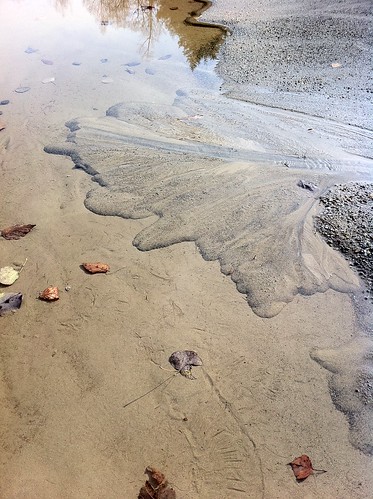
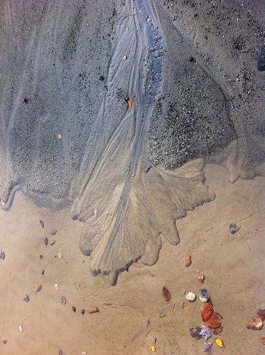
It had many of the same features of a large river delta. By altering the flow of the little trickle of water (creating a dam and then breaking it), we were able to watch the delta experience high water events, and shift its channels. Then, I lowered the level of the 'lake' about an inch by using a shovel to drain the puddle. The water began cutting into the little delta and creating a new delta at the new water level. Soon, the entire geology class was involved. Unfortunately, as is usually the case when many humans are trying to modify the flow of water, by the time we left the little delta was mostly destroyed. Don't feel bad though because it rained last night and probably built itself back in that time.
Speaking of which... the rain last night in Vermont was quite mild. I hear that in Pittsburgh, there was a moderate storm, but nothing particularly intense. The large weather system responsible for this was anything but mild in other parts of the Midwest, however. According to Jeff Masters' blog, this storm was the strongest on record in the interior United States in terms of barometric pressure (hurricanes and nor'easters can still be more intense than this storm was). It led to tornados, severe thunderstorms, and also winds near hurricane force on Lake Superior.
There have been an awful lot of intense storms lately, perhaps due to long-term changes in the climate, or perhaps due to other factors we don't understand. There are some indications that this winter could be quite a stormy one, and may be a winter of very heavy snowfall in many places. It's time to prepare for winter, as the squirrels are doing right now as well.
One of my favorite things about water is how scalable it is. A small trickle in sand will act much the same was as the Earth's largest rivers do. Yesterday I was exploring a gravel pit for a geology class (and learning about eskers!) when I found this 'delta'.
It had many of the same features of a large river delta. By altering the flow of the little trickle of water (creating a dam and then breaking it), we were able to watch the delta experience high water events, and shift its channels. Then, I lowered the level of the 'lake' about an inch by using a shovel to drain the puddle. The water began cutting into the little delta and creating a new delta at the new water level. Soon, the entire geology class was involved. Unfortunately, as is usually the case when many humans are trying to modify the flow of water, by the time we left the little delta was mostly destroyed. Don't feel bad though because it rained last night and probably built itself back in that time.
Speaking of which... the rain last night in Vermont was quite mild. I hear that in Pittsburgh, there was a moderate storm, but nothing particularly intense. The large weather system responsible for this was anything but mild in other parts of the Midwest, however. According to Jeff Masters' blog, this storm was the strongest on record in the interior United States in terms of barometric pressure (hurricanes and nor'easters can still be more intense than this storm was). It led to tornados, severe thunderstorms, and also winds near hurricane force on Lake Superior.
There have been an awful lot of intense storms lately, perhaps due to long-term changes in the climate, or perhaps due to other factors we don't understand. There are some indications that this winter could be quite a stormy one, and may be a winter of very heavy snowfall in many places. It's time to prepare for winter, as the squirrels are doing right now as well.
Wednesday, October 6, 2010
It's the First Day of Spring in Los Angeles
It sounds absurd to say, but in effect it is true, if you define spring as the season of growth and renewal. The first rains of the cold season have arrived in southern California. Click below to read more about the turn of the seasons in the place I lived before I moved to Vermont.
Monday, October 4, 2010
"Super Rainstorm Nicole" Strikes East Coast
On September 30 and October 1, heavy rains affected much of the east coast from North Carolina to Vermont. In eastern North Carolina the rains were extremely intense, and some areas received more than 20 inches of rain! The rain was not quite as severe as that in Vermont but most areas still received over 3 inches of rain (there were around 3 inches of rain in Burlington, 4 in Middlebury, and around 5 in Rutland, for instance. Christopher Bert, an extreme weather expert, has named this rain event 'Super Rainstorm Nicole' because it was in part fed by short-lived Tropical Storm Nicole. Visit this blog for more info on this storm and its similarities to rainfall associated with Hurricane Hugo in 1999.
The storm caused widespread minor flooding in Vermont, but a major disaster was avoided, probably in part because most of September was rather dry. Nevertheless, the rivers were filled to the brim by this rainstorm. Here's what Otter Creek in Middlebury looked like on Friday morning:

The storm caused widespread minor flooding in Vermont, but a major disaster was avoided, probably in part because most of September was rather dry. Nevertheless, the rivers were filled to the brim by this rainstorm. Here's what Otter Creek in Middlebury looked like on Friday morning:
Wednesday, September 29, 2010
Flooding Rains Still Possible in Vermont
Just as a quick update, flooding rains are still in the forecast for Vermont and other areas of the East Coast tomorrow. A tropical storm is expected to quickly form, and then zip north from South Carolina bringing heavy rain along its path.
*** note: images removed because they no longer are relevant - NWS has updated/changed the links. More info on the storm soon.***
These storm systems are small in size and hard to predict so this is not an easy forecast. Needless to say, however, anyone from New York State south to South Carolina should be ready for the possibility of some very heavy rain.
I am hoping the downpour (if it happens) doesn't ruin the fall foliage!
Monday, September 27, 2010
Rainy times in Vermont
Rainy times have come to Vermont. After a relatively dry late summer, fall is arriving, and is bringing copious rain. As I type this it is raining outside, and it has been for most of the day. It will be raining on and off for much of the rest of the week too, and if some computer models are correct, it could be very rainy indeed.

Subscribe to:
Posts (Atom)