Showing posts with label Hurricane. Show all posts

Thursday, September 8, 2011

Hurricane Irene Notebook

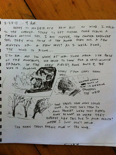
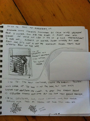
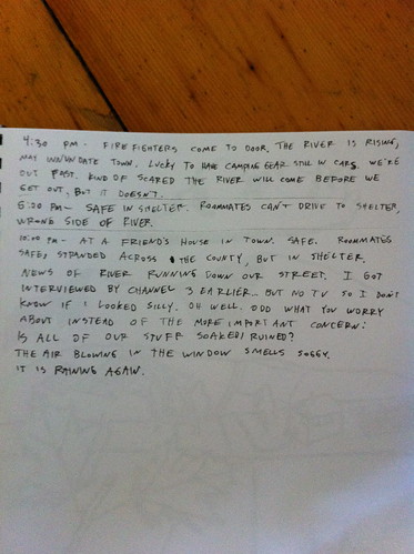
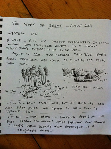
During Hurricane Irene I recorded some observations in a notebook, along with a few little sketches.  It's not the most detailed journal, and doesn't have all that much art (how do you draw a hurricane?) but I think it's interesting so I am posting it here.  The most notable thing I observed, I think, is the fact that in many areas, such as East Middlebury, the storm didn't seem like THAT big of a deal... and I wrote something to that effect, and then minutes later the fire department came to our door and told us we had to evacuate before the river went down Main Street.    This has been echoed by others in other areas, and speaks to the fact that flash flooding is dependent on what happens upstream, not just what happens where you are.

Also, I noticed an interesting smell when driving through the start of the storm, and have heard elsewhere that others observed the same thing... did anyone else smell anything interesting or out of place during the approach of the storm?

The journal starts in the Berkshires of Massachusetts, and then moves to East Middlebury, Vermont.

Irene Notebook 1

Irene Notebook 2

Irene Notebook 3

Irene Notebook 4


Wednesday, August 31, 2011

Preparing for or Preventing the Next Vermont Flood

Irene has come and gone from Vermont, but we are going to be dealing with her effects for a long time.  Homes and businesses are destroyed, roads and bridges washed out, and people displaced and understandably concerned.

Irene was an 'almost-worst-case-scenario' for Vermont, and hopefully we won't see anything like it again in our lifetimes.  However, floods are a part of Vermont life and we will certainly face other damaging floods in the years to come.  While we can't completely stop them, there are things we can do to decrease their intensity and increase our preparedness when they do occur.

In some ways, reducing flooding in Vermont is harder than in many areas.  Unlike Pittsburgh, with highly urbanized, modified watersheds, or California, with its channelized streams and massive habitat loss, Vermont is a mainly rural state with vast, healthy forests and small towns.  Still, there is much we can do to reduce risk and impact of floods.

This post includes some ideas I have about how to reduce flooding risk, prepare for floods, and better cope when they do occur.  If you think these ideas make sense, please share this with others.  If you think they don't make sense, leave a comment and tell me why.  The most important thing right now, aside from cleanup and repairs, is looking ahead together as a state to make sure nothing like this happens again.

Below are my ideas, in somewhat random order:


Friday, August 26, 2011

Friday Vermont Hurricane Irene Update

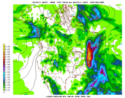
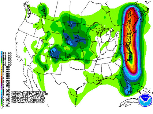
I've been watching Hurricane Irene closely, as have many people in the New England area.  There is, as always, a lot of uncertainty in the track of the storm.  There was some good news today in that the storm is not as strong as it could have been.  However, I'm worried about the possible impacts of the rain on Vermont, though.  In that same Jeff Masters post I noticed one total rainfall forecast:
aug26_rain

So, that particular map seems to indicate that there could be 7 inches of rain in most of the Vermont side of the Champlain Valley, and at least as much in the southern Green Mountains.  Most of that would be Sunday afternoon through Monday morning.  The NWS is calling for 3 to 5 inches of rain in the Champlain Valley and up to 7 inches in the mountains.  This is less than the scenario above, but still enough to cause flooding.  My guess is we will see some roads washed out and flooding in some areas near rivers.

One important thing to note about that map, though, is just how narrow that predicted area of heavy rain is.  There's a good chance any one spot will miss out.  I don't want to wish that 7 inches of rain on New Hampshire or the Adirondacks, but I really hope it doesn't hit Vermont.  I love big storms... but this is excessive.

(One interesting thought I just had was that if winter storms this intense formed in Vermont, this would be 6 or 7 FEET of snow out of one storm.  Luckily, winter storms generally don't hold as much moisture and energy as hurricanes)

At this point it appears that the 'best case' scenario of the storm being pushed out to see is very, very unlikely.

I don't want to cause people to panic, and as long as you live on high ground, you will be quite safe.  Just stay away from the rivers for a while, and most importantly, DO NOT DRIVE INTO FLOODWATERS.  Sometimes it looks like the water flowing over a bridge is just a few inches deep... but in reality, the bridge is 100 yards downstream rather than still attached to the road.

Thursday, August 25, 2011

Quick Vermont Hurricane Irene Update

There's a lot of info on Hurricane Irene already out there but I thought a quick update on its effects on Vermont was appropriate.

There was a great update by Matt Suskoski on the Weather Rapport blog.  This blog, at blogs.burlingtonfreepress.com/weather/, is a good place to get updates, as is the official NWS site at http://www.erh.noaa.gov/btv/ .

The storm has shifted west and slowed down a bit.  This is a bit of good news for me personally, because I'm planning a trip to Western Massachusetts on Friday and it looks like by leaving early Sunday morning we'll avoid most of the storm.  The bad news is it will follow us back to Vermont.  And, since it is moving slower than expected, it may also stay in Vermont longer than expected.  Right now, some computer models predict that the Irene will pass over Vermont still at tropical storm strength... and very wet.  Most areas of Vermont would get at least  5 inches of rain if this model were correct!  Of course, hurricanes are very hard to forecast, and it could still miss the state entirely.  It's worth noting though that Otter Creek in Middlebury was noticeably higher than its normal summer level today, and that heavy rain may happen today with thunderstorms not associated with the hurricane... so the worst case scenario is a pretty nasty one that could leave us with significantly worse flooding than this year's nasty spring thaw or May thunderstorms.

Picture 14

Above: A model prediction of 4 to 8 inches of rain in Vermont from Irene.  These models sometimes miss the local effects of mountains so it's not impossible that areas of the Green Mountains would get over 10 inches of rain if this model were correct.  Yikes!

We're far from the river and in a very solid old building so I doubt we'll have flooding in our home, but there's a good chance that many bridges will be washed out, roads will be covered in mud, power will be out, and no one will be going anywhere for a few days.  Luckily we've got a lot of food stored here.  You should too.  Make sure you have plenty of food, water, batteries, and other emergency supplies available, because you may need them!  I'll try to post updates but for emergency info, you are better off checking the National Weather Service site above and listening to your local authorities.  If you are in an area that flooded already this year (except lake flooding) or has flooded in the past you may consider staying at a friend's house Sunday night.

Update Thursday afternoon: Still definitely looks like Irene could have a big impact on Vermont.  One recent computer model I looked held the brunt of the storm back until late Sunday night or Monday morning.  There's also the chance it will miss us completely.  We'll see!