
East Middlebury lies on a glacial delta that formed when glacial Lake Vermont filled the Champlain Valley. The river emerges from the mountains and changes from a steep, gorge-confined river, to a meandering, slow stream as it passes through East Middlebury. In the process, it drops sediment from the mountains. Larger rocks are dropped near the gorge, gravel and sand carried further, silt deposited in slow-water areas, and clay carried out of the area (and often all the way to Lake Champlain).
Anyway, back to Irene... the storm created a historic flood that had big effects on the river. But, in the rockbound gorge, very little changed.
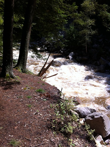
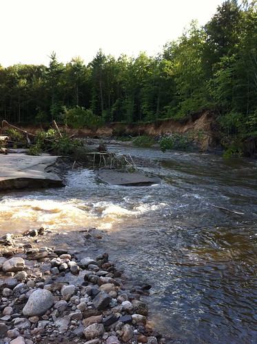
The river was RAGING the day after the Irene floods. I very carefully took this picture, making sure to avoid the banks of the river, which could have been eroded by the floods. If I fell into this, I'd be done for!
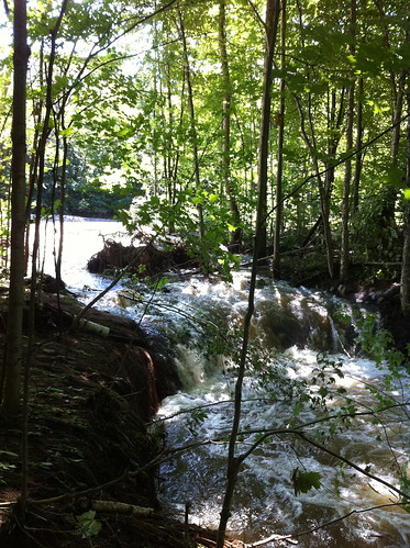
At the base of the mountains, the river passes through this even narrower gorge under the Highway 125 bridge:
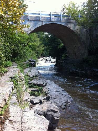
Sometimes we go swimming here, but not today. (Note: After Irene, do NOT dive into swimming holes, even in areas that have always been safe, without checking if it is still OK first. Irene's flood moved some enormous boulders and changed where sand and gravel bars are located... previously safe areas may be deadly to divers now.)
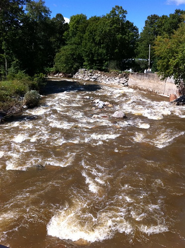
After leaving the gorge, the river slows down a bit and passes through town. Here's the river from Grist Mill Road, looking downstream. As the name implies, there was once a mill here. You can see the features in place to protect the town from the river. They have worked well for many years, but this flood was too much for them. Upstream from here, the river jumped its banks and ran down Highway 125 for a while, flooding basements and eroding driveways. Note that the river is still rather confined by its banks and these levees.
Between Grist Mill Road and Route 7, the Middlebury River drops a lot of sediment. Its course begins to wander, and sycamores and cottonwoods, rare in Vermont, line its banks. This part of the river is very dynamic, and changed a LOT during the floods.
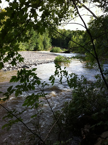
Both these areas are almost unrecognizable since the river has changed so much.
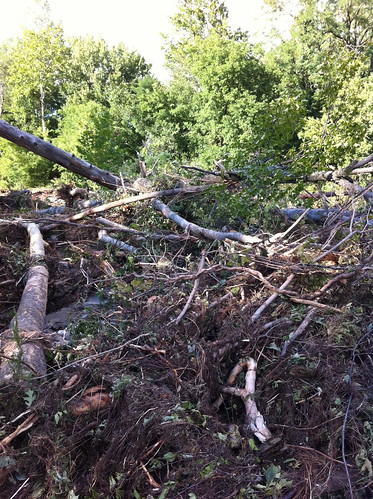
Trees from upstream are laying in piles everywhere. This looks like a lot of destruction, but trees in rivers provide habitats for lots of creatures, including trout and the species they eat.
Above, a side channel of the river erodes backwards towards the main stream. Eventually this channel may reach the main channel and 'steal' its water, causing the river to shift course. In this case, this happening would not endanger structures since it's in the undeveloped flood plain. The old river channel would become a wetland, then gradually fill in with cottonwood and sycamore trees. Over the thousands of years since the last Ice Age, this process has created a dynamic, diverse ecosystem along the river. The Middlebury Area Land Trust has obtained a conservation easement along part of the river in this section, which will allow the river to continue unrestrainted in its wanders.
Downstream from Highway 7, the Middlebury River has dropped most of its heavy sediment, and it slows down and meanders extensively. I didn't visit this section yesterday, because it was more heavily impacted by flooding and I didn't want to get in the way of residents dealing with flood damage. I'll visit the lower section of the river at a later date and see how it fared during the floods.
Here's a Google map of the Middlebury River at the gorge:
View Larger Map
Note: please respect private property rights and don't try to access the river through private property. There are places where you can see the river near the 125 and 7 bridges. The MALT parcel is not yet developed for public access, but may be in the future. This river is very sensitive to rainfall and rises fast during floods, so stay away from the river, especially in the gorge, during and after heavy rains!
Charlie,
ReplyDeleteThanks for the update. It’s great that you included the glacial history of this location in your description of the river. East Middlebury’s location at the site of a huge, 13,000 year old delta is crucial to is current condition. The village is built on a rather flat surface which is a floodplain created as the river carved through the loose sands and gravels of that delta. The original delta surface is some 60 feet higher at the level occupied by Lake Vermont when the delta was being built. You can find remnants of that delta surface, and steep sandy banks eroded into it, to the north of the village. The East Middlebury floodplain surface was carved after the glacial lake drained, during the time that the Champlain Sea occupied the lower parts of the Champlain Valley. The floodplain was probably resurfaced throughout the Holocene as floods rerouted the river and reworked the sediments. Those sediments include some deltaic sand and gravel, but also lots of material brought down more recently from the mountains. Today, much of the floodplain has been abandoned by the river, but obviously not all of it or your evacuation would not have occurred (and you would not have been on TV).
The steep gorge upstream from the village is a good place to contemplate the erosive power of flowing water. When the New Haven River was forced from its Lincoln Valley watershed into the Ripton watershed of the Middlebury River, Lake Vermont was still filling the Champlain Valley. It was glacial ice that forced the New Haven River to spill into Ripton, and glacial ice was also covering the site of East Middlebury. So the raging, glacial torrent of the combined New Haven and Middlebury Rivers was diverted by the glacier south along Upper Plains Road where it created spectacular kame terraces, kettles, and other deltas. By the time the glacier had retreated to Canada allowing Lake Vermont to drain and the Middlebury River to flow down its present gorge, the New Haven River was carving through its own delta at Bristol. So the Middlebury River should be given sole credit for any erosion in the lower part of the gorge. Most of the erosive work it did was to remove the unconsolidated material (boulders, cobbles, gravel, etc.) that clogged the valley when the ice receded. The bedrock of the canyon has probably not been altered that much during the Holocene.
We live in an eminently interesting place.
Chris
Chris, thanks so much for that additional info. I should add that information you gave me about the area 2 years ago is the basis of so much of what I know about the area (and posted here), and part of why I chose to move here :) Thanks for the correction of the timing of the New Haven River flowing this way. I guess I can imagine thousands of floods like this one being enough to carve a gorge like this! Of course, the gorge itself must predate the ice age by a lot!
ReplyDeleteI'm wondering about the area around Belmont Vt.
ReplyDeleteA friend emailed on the 28th that water was coming in the basement of the house they had evacuated to.
At the time it looked like Irene was in Belmont also.
Have not heard from them since.
I haven't heard anything about Belmont, it's pretty far from East Middlebury. That area was very hard hit, but I haven't heard of any injuries or anything. They may be isolated from power and phone... but people are at this moment working to reconnect towns and bring food and water to them in the mean time. A good source of info if you have facebook is http://www.facebook.com/pages/Vermont-Flooding-2011/212455332141871 , the Vermont Flooding 2011 group.
ReplyDeleteThank you for a prompt reply. If I knew how to "sign up" I would.
ReplyDeleteI'm confident the couple I am concerned about are OK - just thought you might have some more "local" knowledge.
I've been interested in Water and in all that entails for some years.
I have bookmarked your blog and will get down to reading once I have sorted some pressing issues (water and electric)
No worries... it's just a blogger account.
ReplyDeleteWhile tiny, Vermont is also very divided by large mountains. They often say 'you can't get there from here' referring to such, a town 50 miles away as the crow flies can take many hours to drive to, especially in winter. So I guess that's what I mean by Belmont being 'far' away even though it looks close on the map :)
Thanks for following the blog! If I hear anything else about Belmont I will post it, otherwise, check out the facebook group, or follow @swatermavt on Twitter (the Twitter name looks like slow water movement, doesn't it? It's just a coincidence).
Best of luck getting the utilities back up!