
There was a great update by Matt Suskoski on the Weather Rapport blog. This blog, at blogs.burlingtonfreepress.com/weather/, is a good place to get updates, as is the official NWS site at http://www.erh.noaa.gov/btv/ .
The storm has shifted west and slowed down a bit. This is a bit of good news for me personally, because I'm planning a trip to Western Massachusetts on Friday and it looks like by leaving early Sunday morning we'll avoid most of the storm. The bad news is it will follow us back to Vermont. And, since it is moving slower than expected, it may also stay in Vermont longer than expected. Right now, some computer models predict that the Irene will pass over Vermont still at tropical storm strength... and very wet. Most areas of Vermont would get at least 5 inches of rain if this model were correct! Of course, hurricanes are very hard to forecast, and it could still miss the state entirely. It's worth noting though that Otter Creek in Middlebury was noticeably higher than its normal summer level today, and that heavy rain may happen today with thunderstorms not associated with the hurricane... so the worst case scenario is a pretty nasty one that could leave us with significantly worse flooding than this year's nasty spring thaw or May thunderstorms.
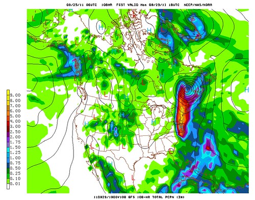
Above: A model prediction of 4 to 8 inches of rain in Vermont from Irene. These models sometimes miss the local effects of mountains so it's not impossible that areas of the Green Mountains would get over 10 inches of rain if this model were correct. Yikes!
We're far from the river and in a very solid old building so I doubt we'll have flooding in our home, but there's a good chance that many bridges will be washed out, roads will be covered in mud, power will be out, and no one will be going anywhere for a few days. Luckily we've got a lot of food stored here. You should too. Make sure you have plenty of food, water, batteries, and other emergency supplies available, because you may need them! I'll try to post updates but for emergency info, you are better off checking the National Weather Service site above and listening to your local authorities. If you are in an area that flooded already this year (except lake flooding) or has flooded in the past you may consider staying at a friend's house Sunday night.
Update Thursday afternoon: Still definitely looks like Irene could have a big impact on Vermont. One recent computer model I looked held the brunt of the storm back until late Sunday night or Monday morning. There's also the chance it will miss us completely. We'll see!
No comments:
Post a Comment