During a year of some of the worst flooding the United States has ever seen, spanning just about every state except those in severe drought (such as Texas), the US federal government is planning to shut down 376 stream gages due to 'lack of funding' (Thanks to @wunderground on Twitter for this link). Apparently, a USGS stream gage costs around $15,700 a year to maintain, a minimal sum when compared to its benefits. Stream gages allow for accurate flood warnings, that save lives, livestock and property... allow for flood plans to be estimated more accurately... and provide information on water supply during times of drought.
I'm trying not to get into politics too deeply here, since it is a contentious issue and I feel that this is a non-partisan issue and need. But, when I think about other things our government and economy expend money and resources on, and how tiny a speck the cost of a stream gage is in the grand picture, I am disgusted. Are human lives, or our homes and everything in them, or our, businesses, crops, and livestock that are our livelihood... not worth $15,700 a year in each of these watersheds? Are we, the people of the United States, unable or unwilling to demand that our representative government provide cheap and effective services that protect us from loss of life, or is the system so broken that the government is not at all representative of us any more?
There should be many more stream gages being installed, none being removed, and many more rain gages also being added in upper watershed areas.
If our government is unwilling or unable to provide stream and rain gages, I think we need to look into alternatives. Perhaps a citizen-science type network of people could be assembled who are willing to invest a lesser sum in an automated weather station (probably under $500.00 - perhaps with a tax rebate or grant?) or some form of 'cheap and dirty' stream gage. Perhaps state governments or private industry could step in (I know I keep mentioning Google, but I know they could be a part of this). If all else fails, we need a watershed/flood smartphone/computer reporting network (as mentioned before in this blog I am partial to the iNaturalist / whatsinvasive format). Even a normal webcam aimed at a $3 yardstick in the creek would be better than nothing (though it was just pointed out to me that it would be impossible to see at night, when floods are most dangerous!)
The VTResponse people are doing an amazing job and helping organize flood recovery in Vermont. Who is going to step forward to protect us from the next flood? We have great people at the USGS already willing to process the data and inform the authorities of imminent flooding... but they can't do that without having the data in the first place.

Stories about the ways water moves through natural and human-constructed landscapes... what we can learn from it and how we can use old and new ideas to understand, appreciate, and sustainably use this resource.
Showing posts with label Iphone. Show all posts
Showing posts with label Iphone. Show all posts
Friday, September 9, 2011
Saturday, July 16, 2011
iNaturalist - more tech-based citizen science
In my search for fun, useful citizen science projects that involve smartphones and location data, I somehow managed to miss iNaturalist until now. It's too bad, because this project seems to work a lot better than other ones I've tried out. Among other things:
- species are organized on a database that is hierarchical based on taxonomy, making it easy to search, make partial identifications, and obtain linked info.
- For some species, range maps are already present, and there are plans to upload more
- You have the option to control your geoprivacy, meaning you can upload location data that only you and the site admins can see.
- Projects are versatile and seem easy to set up (I haven't tried yet, though).
- The iPhone app and website are easy to use and not buggy.
- There are a lot of neat people on the website who will help ID organisms. In some cases, I've had IDs entered within minutes of an upload
- It is easy to save observations on the phone and upload them when you are in a WiFi area.
- It's fun!
So far, it doesn't appear that there is an easy way to track abiotic features of the natural world, such as weather events, urban hydrology, or geologic features. That may, in fact, be too off-topic for the website, but I hope someone creates one for those things someday.
If you're interested, try it out! You can see/follow my profile and sightings here.
Thursday, December 30, 2010
A Lake Explore; Citizen Science using Project Noah App
Between the subzero wind chills of Vermont winter and a big project deadline, I'd been spending far too much time inside in the past few weeks. With the deadline passed and an early winter thaw building in, it was time to get outside. I decided to take a walk on the shores of Lake Champlain. In addition to getting outside, I wanted to take advantage of the 'balmy' 33 degree air to try out Project Noah, a citizen science app for the Iphone.
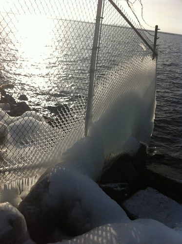
The air temperature has been below freezing for most of December, but Lake Champlain is large and deep, and the wide portion of the lake near Burlington, Vermont has not frozen over. The splashing waves deposit ice on everything near the lake, including branches, rocks, and even fences.
Click below to take a virtual tour of my walk, using Project Noah.
Monday, December 13, 2010
More Place-Based Technology
Thursday, December 9, 2010
End of semester crunch; more apps
It's the end of the semester, and I'm really busy. So busy in fact that I haven't made a blog post this week. I am actually typing this from an iPhone on a bus so this entry is going to be a short one.
Winter has arrived in Vermont and Pittsburgh. Both areas have received significant snow, and Vermont hasn't been above freezing in about a week. It seems like an odd time to think about wandering around outside documenting creek flow, but of course this is exactly what I have been doing, in between final projects and grading papers. I've managed to get a few vermont creeks on the Creekwatch app. My friend also showed me two other apps - project Noah and epicollect. Project Noah is an app similar to creekwatch, except that people photograph and report animals, plants, and fungi instead of creeks. It's a really neat idea but I haven't had time to do much with it quite yet. Epicollect is a make your own type app... Later thus month I hope to make a Slow Water epi-app and try that out too.
More to follow soon!
Monday, November 22, 2010
Neat Iphone App for Monitoring Watercourses: "Creek Watch"
I just learned about a very neat app from the LA Creek Freak blog.
The CreekWatch app, developed by IBM, allows you to take photros of a creek and report the amount of water and whether or not there is any trash present.
 (picture from the Iphone App Store)
The CreekWatch app, developed by IBM, allows you to take photros of a creek and report the amount of water and whether or not there is any trash present.
Subscribe to:
Posts (Atom)