During a year of some of the worst flooding the United States has ever seen, spanning just about every state except those in severe drought (such as Texas), the US federal government is planning to shut down 376 stream gages due to 'lack of funding' (Thanks to @wunderground on Twitter for this link). Apparently, a USGS stream gage costs around $15,700 a year to maintain, a minimal sum when compared to its benefits. Stream gages allow for accurate flood warnings, that save lives, livestock and property... allow for flood plans to be estimated more accurately... and provide information on water supply during times of drought.
I'm trying not to get into politics too deeply here, since it is a contentious issue and I feel that this is a non-partisan issue and need. But, when I think about other things our government and economy expend money and resources on, and how tiny a speck the cost of a stream gage is in the grand picture, I am disgusted. Are human lives, or our homes and everything in them, or our, businesses, crops, and livestock that are our livelihood... not worth $15,700 a year in each of these watersheds? Are we, the people of the United States, unable or unwilling to demand that our representative government provide cheap and effective services that protect us from loss of life, or is the system so broken that the government is not at all representative of us any more?
There should be many more stream gages being installed, none being removed, and many more rain gages also being added in upper watershed areas.
If our government is unwilling or unable to provide stream and rain gages, I think we need to look into alternatives. Perhaps a citizen-science type network of people could be assembled who are willing to invest a lesser sum in an automated weather station (probably under $500.00 - perhaps with a tax rebate or grant?) or some form of 'cheap and dirty' stream gage. Perhaps state governments or private industry could step in (I know I keep mentioning Google, but I know they could be a part of this). If all else fails, we need a watershed/flood smartphone/computer reporting network (as mentioned before in this blog I am partial to the iNaturalist / whatsinvasive format). Even a normal webcam aimed at a $3 yardstick in the creek would be better than nothing (though it was just pointed out to me that it would be impossible to see at night, when floods are most dangerous!)
The VTResponse people are doing an amazing job and helping organize flood recovery in Vermont. Who is going to step forward to protect us from the next flood? We have great people at the USGS already willing to process the data and inform the authorities of imminent flooding... but they can't do that without having the data in the first place.

Stories about the ways water moves through natural and human-constructed landscapes... what we can learn from it and how we can use old and new ideas to understand, appreciate, and sustainably use this resource.
Showing posts with label Vermont. Show all posts
Showing posts with label Vermont. Show all posts
Friday, September 9, 2011
Thursday, September 8, 2011
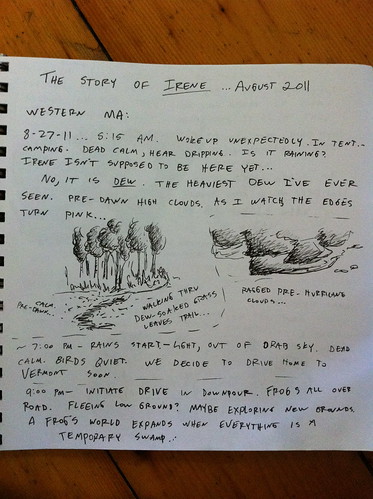
Hurricane Irene Notebook
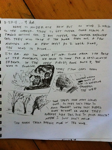
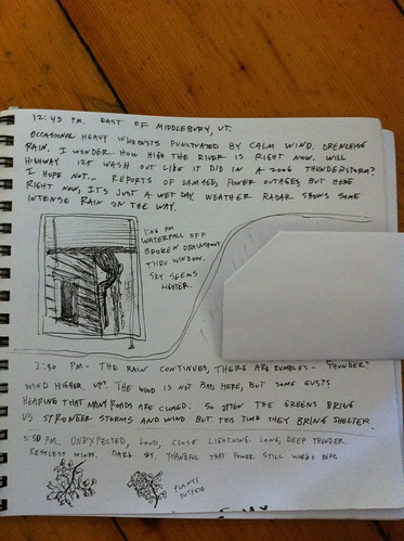
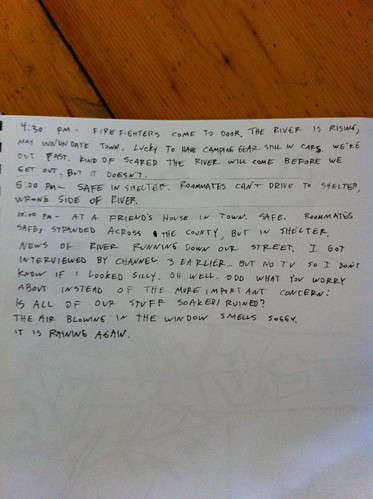
During Hurricane Irene I recorded some observations in a notebook, along with a few little sketches. It's not the most detailed journal, and doesn't have all that much art (how do you draw a hurricane?) but I think it's interesting so I am posting it here. The most notable thing I observed, I think, is the fact that in many areas, such as East Middlebury, the storm didn't seem like THAT big of a deal... and I wrote something to that effect, and then minutes later the fire department came to our door and told us we had to evacuate before the river went down Main Street. This has been echoed by others in other areas, and speaks to the fact that flash flooding is dependent on what happens upstream, not just what happens where you are.
Also, I noticed an interesting smell when driving through the start of the storm, and have heard elsewhere that others observed the same thing... did anyone else smell anything interesting or out of place during the approach of the storm?
The journal starts in the Berkshires of Massachusetts, and then moves to East Middlebury, Vermont.
Wednesday, August 31, 2011
Preparing for or Preventing the Next Vermont Flood
Irene has come and gone from Vermont, but we are going to be dealing with her effects for a long time. Homes and businesses are destroyed, roads and bridges washed out, and people displaced and understandably concerned.
Irene was an 'almost-worst-case-scenario' for Vermont, and hopefully we won't see anything like it again in our lifetimes. However, floods are a part of Vermont life and we will certainly face other damaging floods in the years to come. While we can't completely stop them, there are things we can do to decrease their intensity and increase our preparedness when they do occur.
In some ways, reducing flooding in Vermont is harder than in many areas. Unlike Pittsburgh, with highly urbanized, modified watersheds, or California, with its channelized streams and massive habitat loss, Vermont is a mainly rural state with vast, healthy forests and small towns. Still, there is much we can do to reduce risk and impact of floods.
This post includes some ideas I have about how to reduce flooding risk, prepare for floods, and better cope when they do occur. If you think these ideas make sense, please share this with others. If you think they don't make sense, leave a comment and tell me why. The most important thing right now, aside from cleanup and repairs, is looking ahead together as a state to make sure nothing like this happens again.
Below are my ideas, in somewhat random order:
Monday, August 29, 2011
East Middlebury Irene Flood Update Part 1
After spending the night at a friend's house we returned to East Middlebury early this morning. Here's what we found:
Otter Creek leaving Middlebury... high but not dangerous. The crest hasn't arrived here yet, though. The sky looks nasty, but the clouds were clearing.
Sunrise.
East Main Street was not destroyed, or buried in mud. It was obvious that the river had run down the road, though. There was some debris:
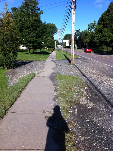

Hard to see above, but there is a high water line near the sidewalk.
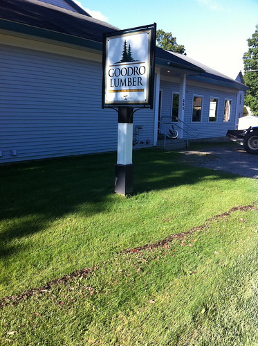
Goodrow Lumber was spared, except for some very minor parking area damage. Mac's Market across the street was also spared and was open. They told me they had to open a bit late, but everything was fine. Nearby, many people were pumping out their basements. Our home was undamaged, as it is a couple of feet above the road. Our garden was not damaged by flooding, but was damaged by the groundhog again. I was hoping it had drowned, but apparently not.
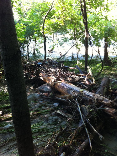
The river is raging, and is almost unrecognizable. Trees had been uprooted and existing logs have washed away. A 20' tall, 50' long section of vertical bank was created.
Here's what it looked like a few weeks ago, when the water was low:
Note that the young trees to the left were almost completely destroyed (there is a reason they were young... they are on a gravel bar. That area floods often). The leaning sycamore to the right somehow survived the flood.
The flood plain along the river had been buried in mud and debris.
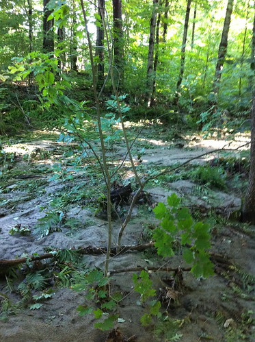
Unlike human structures, floodplain forest is well adapted to frequent floods. This deposit of silt and sand will provide nutrients for the plants, and will benefit the flood-adapted plants in this area such as sycamore, cottonwood, and ostrich fern.
Later today I will check out the gorge and the bridges, and find where the river jumped its banks and flowed down the road. Unfortunately, homes in that area probably sustained more damage.
Also, if you want to see me as a soggy flood refugee, I was interviewed in Channel 3 news yesterday evening.
Otter Creek leaving Middlebury... high but not dangerous. The crest hasn't arrived here yet, though. The sky looks nasty, but the clouds were clearing.
Sunrise.
East Main Street was not destroyed, or buried in mud. It was obvious that the river had run down the road, though. There was some debris:
Hard to see above, but there is a high water line near the sidewalk.
Goodrow Lumber was spared, except for some very minor parking area damage. Mac's Market across the street was also spared and was open. They told me they had to open a bit late, but everything was fine. Nearby, many people were pumping out their basements. Our home was undamaged, as it is a couple of feet above the road. Our garden was not damaged by flooding, but was damaged by the groundhog again. I was hoping it had drowned, but apparently not.
The river is raging, and is almost unrecognizable. Trees had been uprooted and existing logs have washed away. A 20' tall, 50' long section of vertical bank was created.
Here's what it looked like a few weeks ago, when the water was low:
Note that the young trees to the left were almost completely destroyed (there is a reason they were young... they are on a gravel bar. That area floods often). The leaning sycamore to the right somehow survived the flood.
The flood plain along the river had been buried in mud and debris.
Unlike human structures, floodplain forest is well adapted to frequent floods. This deposit of silt and sand will provide nutrients for the plants, and will benefit the flood-adapted plants in this area such as sycamore, cottonwood, and ostrich fern.
Later today I will check out the gorge and the bridges, and find where the river jumped its banks and flowed down the road. Unfortunately, homes in that area probably sustained more damage.
Also, if you want to see me as a soggy flood refugee, I was interviewed in Channel 3 news yesterday evening.
Sunday, August 28, 2011
Evacuated.
Vermont has been devastated by Irene's flooding. It ended up even worse than I thought it was.
We were evacuated from our home at 4:30 pm today. Soon after we left the river started flowing down the main street of our village. We are safe as are our friends and loved ones. We are staying with friends now. Hopefully we can go home tomorrow and hopefully our home is ok. We don't think the floodwaters got inside... But we don't know. It seems that the river jumped into an old channel that main street was built on.
There will be plenty more to post about this tomorrow, but as I am on my phone I can't say much more. I will say this flood will change our relationships with our Vermont rivers as dramatically as the floods in the 1920s... And hopefully in different ways. And hopefully our decisions back then don't end up making the flooding in Montpelier even worse than otherwise.
Sleep well, Vermont... Tomorrow is a day to start diging out.
Friday, August 26, 2011
Friday Vermont Hurricane Irene Update
I've been watching Hurricane Irene closely, as have many people in the New England area. There is, as always, a lot of uncertainty in the track of the storm. There was some good news today in that the storm is not as strong as it could have been. However, I'm worried about the possible impacts of the rain on Vermont, though. In that same Jeff Masters post I noticed one total rainfall forecast:
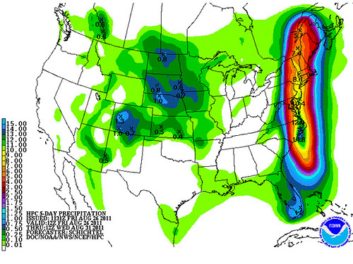
So, that particular map seems to indicate that there could be 7 inches of rain in most of the Vermont side of the Champlain Valley, and at least as much in the southern Green Mountains. Most of that would be Sunday afternoon through Monday morning. The NWS is calling for 3 to 5 inches of rain in the Champlain Valley and up to 7 inches in the mountains. This is less than the scenario above, but still enough to cause flooding. My guess is we will see some roads washed out and flooding in some areas near rivers.
One important thing to note about that map, though, is just how narrow that predicted area of heavy rain is. There's a good chance any one spot will miss out. I don't want to wish that 7 inches of rain on New Hampshire or the Adirondacks, but I really hope it doesn't hit Vermont. I love big storms... but this is excessive.
(One interesting thought I just had was that if winter storms this intense formed in Vermont, this would be 6 or 7 FEET of snow out of one storm. Luckily, winter storms generally don't hold as much moisture and energy as hurricanes)
At this point it appears that the 'best case' scenario of the storm being pushed out to see is very, very unlikely.
I don't want to cause people to panic, and as long as you live on high ground, you will be quite safe. Just stay away from the rivers for a while, and most importantly, DO NOT DRIVE INTO FLOODWATERS. Sometimes it looks like the water flowing over a bridge is just a few inches deep... but in reality, the bridge is 100 yards downstream rather than still attached to the road.
Thursday, August 25, 2011
Quick Vermont Hurricane Irene Update
There's a lot of info on Hurricane Irene already out there but I thought a quick update on its effects on Vermont was appropriate.
There was a great update by Matt Suskoski on the Weather Rapport blog. This blog, at blogs.burlingtonfreepress.com/weather/, is a good place to get updates, as is the official NWS site at http://www.erh.noaa.gov/btv/ .
The storm has shifted west and slowed down a bit. This is a bit of good news for me personally, because I'm planning a trip to Western Massachusetts on Friday and it looks like by leaving early Sunday morning we'll avoid most of the storm. The bad news is it will follow us back to Vermont. And, since it is moving slower than expected, it may also stay in Vermont longer than expected. Right now, some computer models predict that the Irene will pass over Vermont still at tropical storm strength... and very wet. Most areas of Vermont would get at least 5 inches of rain if this model were correct! Of course, hurricanes are very hard to forecast, and it could still miss the state entirely. It's worth noting though that Otter Creek in Middlebury was noticeably higher than its normal summer level today, and that heavy rain may happen today with thunderstorms not associated with the hurricane... so the worst case scenario is a pretty nasty one that could leave us with significantly worse flooding than this year's nasty spring thaw or May thunderstorms.
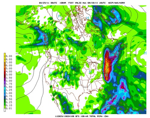
Above: A model prediction of 4 to 8 inches of rain in Vermont from Irene. These models sometimes miss the local effects of mountains so it's not impossible that areas of the Green Mountains would get over 10 inches of rain if this model were correct. Yikes!
We're far from the river and in a very solid old building so I doubt we'll have flooding in our home, but there's a good chance that many bridges will be washed out, roads will be covered in mud, power will be out, and no one will be going anywhere for a few days. Luckily we've got a lot of food stored here. You should too. Make sure you have plenty of food, water, batteries, and other emergency supplies available, because you may need them! I'll try to post updates but for emergency info, you are better off checking the National Weather Service site above and listening to your local authorities. If you are in an area that flooded already this year (except lake flooding) or has flooded in the past you may consider staying at a friend's house Sunday night.
Update Thursday afternoon: Still definitely looks like Irene could have a big impact on Vermont. One recent computer model I looked held the brunt of the storm back until late Sunday night or Monday morning. There's also the chance it will miss us completely. We'll see!
There was a great update by Matt Suskoski on the Weather Rapport blog. This blog, at blogs.burlingtonfreepress.com/weather/, is a good place to get updates, as is the official NWS site at http://www.erh.noaa.gov/btv/ .
The storm has shifted west and slowed down a bit. This is a bit of good news for me personally, because I'm planning a trip to Western Massachusetts on Friday and it looks like by leaving early Sunday morning we'll avoid most of the storm. The bad news is it will follow us back to Vermont. And, since it is moving slower than expected, it may also stay in Vermont longer than expected. Right now, some computer models predict that the Irene will pass over Vermont still at tropical storm strength... and very wet. Most areas of Vermont would get at least 5 inches of rain if this model were correct! Of course, hurricanes are very hard to forecast, and it could still miss the state entirely. It's worth noting though that Otter Creek in Middlebury was noticeably higher than its normal summer level today, and that heavy rain may happen today with thunderstorms not associated with the hurricane... so the worst case scenario is a pretty nasty one that could leave us with significantly worse flooding than this year's nasty spring thaw or May thunderstorms.
Above: A model prediction of 4 to 8 inches of rain in Vermont from Irene. These models sometimes miss the local effects of mountains so it's not impossible that areas of the Green Mountains would get over 10 inches of rain if this model were correct. Yikes!
We're far from the river and in a very solid old building so I doubt we'll have flooding in our home, but there's a good chance that many bridges will be washed out, roads will be covered in mud, power will be out, and no one will be going anywhere for a few days. Luckily we've got a lot of food stored here. You should too. Make sure you have plenty of food, water, batteries, and other emergency supplies available, because you may need them! I'll try to post updates but for emergency info, you are better off checking the National Weather Service site above and listening to your local authorities. If you are in an area that flooded already this year (except lake flooding) or has flooded in the past you may consider staying at a friend's house Sunday night.
Update Thursday afternoon: Still definitely looks like Irene could have a big impact on Vermont. One recent computer model I looked held the brunt of the storm back until late Sunday night or Monday morning. There's also the chance it will miss us completely. We'll see!
Thursday, August 4, 2011
Vermont Summer Dry Spell
It's hard to believe after the soakings of this spring, but Vermont is in the midst of a summer dry spell.
This isn't an extreme drought of the sort that Texas is experiencing. It's quite normal for Vermont to have several weeks of mostly dry weather in midsummer. As is often the case, there have been at least a few thunderstorms in Vermont each afternoon, but they have been small and fast-moving.
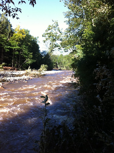
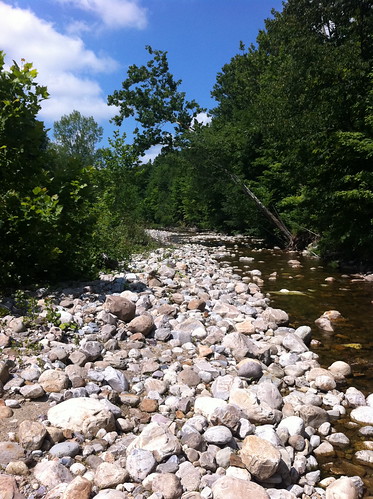
This dry spell isn't phasing the lush green growth in meadows and the forest understory that grew after this spring's rain. It is having an effect on the Middlebury River, though. With a steep, relatively small watershed, the Middlebury River is very sensitive to weather events in the short term. In fact, it reminds me a bit of the washes and canyons in southern California, with one key difference: even during dry periods, the Middlebury River is always flowing. Most rivers and streams in southern California are dry this time of year, especially in areas with wide, cobbly or sandy riverbeds, like the part of the Middlebury River I most frequently visit.
Here's one part of the river, as it looked about a half hour ago:
Here is how that same area looked during the May floods:
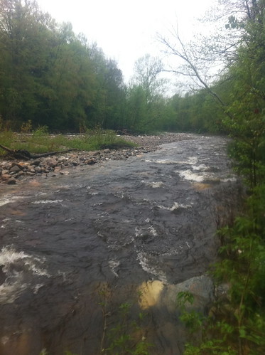
The view isn't from the exact same place, but note the leaning sycamore in both pictures. Note that this is also not the entire flow of the river, as this area has more than one river channel (typical of rivers that are full of cobbles and have a medium gradient). Even still, it really shows how the water level has changed.
The picture also demonstrates how amazingly fast cottonwoods and sycamores grow. Those large saplings to the left are the same trees as the little seedlings in the first picture! When the land you are growing on washes away in floods every few years, you have to mature and set seed fast!
More pictures below:
This isn't an extreme drought of the sort that Texas is experiencing. It's quite normal for Vermont to have several weeks of mostly dry weather in midsummer. As is often the case, there have been at least a few thunderstorms in Vermont each afternoon, but they have been small and fast-moving.
This dry spell isn't phasing the lush green growth in meadows and the forest understory that grew after this spring's rain. It is having an effect on the Middlebury River, though. With a steep, relatively small watershed, the Middlebury River is very sensitive to weather events in the short term. In fact, it reminds me a bit of the washes and canyons in southern California, with one key difference: even during dry periods, the Middlebury River is always flowing. Most rivers and streams in southern California are dry this time of year, especially in areas with wide, cobbly or sandy riverbeds, like the part of the Middlebury River I most frequently visit.
Here's one part of the river, as it looked about a half hour ago:
Here is how that same area looked during the May floods:
The view isn't from the exact same place, but note the leaning sycamore in both pictures. Note that this is also not the entire flow of the river, as this area has more than one river channel (typical of rivers that are full of cobbles and have a medium gradient). Even still, it really shows how the water level has changed.
The picture also demonstrates how amazingly fast cottonwoods and sycamores grow. Those large saplings to the left are the same trees as the little seedlings in the first picture! When the land you are growing on washes away in floods every few years, you have to mature and set seed fast!
More pictures below:
Wednesday, July 20, 2011
Vermont Summer Storms and Fickle Mountain Streams
The mountain streams and small rivers of Vermont are one of the state's treasures. These streams, which hold copious water all year, are a huge draw to people looking to fish, swim, wade, dive, and explore. These activities are an important part of the summer in Vermont and other areas with mountain streams, and by all means people should be enjoying these places. However, they need to do so with respect for the fact that these waterways change fast, and can be quite dangerous at times.
This month a tragedy struck at the Bolton Potholes when a 12 year old boy drowned. Another tragedy was narrowly averted when two people were rescued from Huntington Gorge. There are many factors that can lead to danger, including dangerous cliff diving, drunken exploits into dangerous waters, or just bad luck. One of the strongest factors, it seems, and one that is also often not well understood, is just how quickly these rivers and streams change during and after summer storms.
This month a tragedy struck at the Bolton Potholes when a 12 year old boy drowned. Another tragedy was narrowly averted when two people were rescued from Huntington Gorge. There are many factors that can lead to danger, including dangerous cliff diving, drunken exploits into dangerous waters, or just bad luck. One of the strongest factors, it seems, and one that is also often not well understood, is just how quickly these rivers and streams change during and after summer storms.
Monday, July 11, 2011
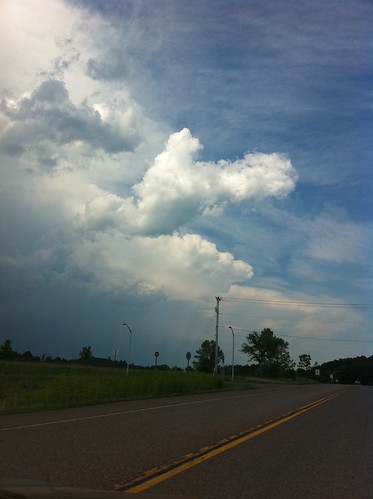
July 6 Severe Thunderstorms near Burlington, Vermont
On July 6, another line of severe thunderstorms passed through Vermont, causing wind damage in many areas. I had the opportunity to get a very good view of these storms, because we ended up driving through the line in Charlotte, Vermont.
Thursday, June 23, 2011
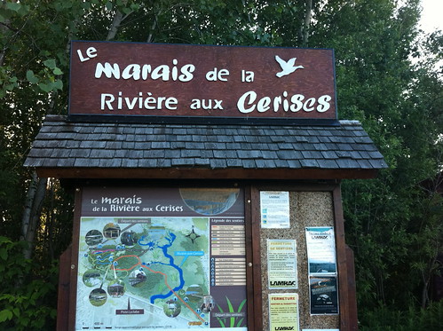
Slow Water in Canada: Le Marais de la Rivière aux Cerise. (and adventures in northern Vermont)
Last weekend we took a trip to Magog, Canada, at the north end of Lake Memphremagog. There we found a very neat wetland preserve: Le Marais de la Rivière aux Cerise (the Cherry River Marsh).
Thursday, December 30, 2010
A Lake Explore; Citizen Science using Project Noah App
Between the subzero wind chills of Vermont winter and a big project deadline, I'd been spending far too much time inside in the past few weeks. With the deadline passed and an early winter thaw building in, it was time to get outside. I decided to take a walk on the shores of Lake Champlain. In addition to getting outside, I wanted to take advantage of the 'balmy' 33 degree air to try out Project Noah, a citizen science app for the Iphone.
The air temperature has been below freezing for most of December, but Lake Champlain is large and deep, and the wide portion of the lake near Burlington, Vermont has not frozen over. The splashing waves deposit ice on everything near the lake, including branches, rocks, and even fences.
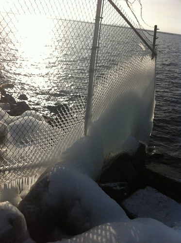
Click below to take a virtual tour of my walk, using Project Noah.
The air temperature has been below freezing for most of December, but Lake Champlain is large and deep, and the wide portion of the lake near Burlington, Vermont has not frozen over. The splashing waves deposit ice on everything near the lake, including branches, rocks, and even fences.
Click below to take a virtual tour of my walk, using Project Noah.
Thursday, December 2, 2010
Phase Change, Part I
I spent some of the long Thanksgiving weekend at the shore in Connecticut, where the temperatures were relatively warm. Driving back to Vermont on Saturday we mostly traveled under blue skies and scattered clouds, with temperatures above freezing. This all changed when we crossed over the Green Mountains. When we reached the eastern side of the mountains it was lightly snowing. When we crossed over the divide, the snow intensity increased, and in Rutland, in the Champlain Valley, we were faced with a full-on snow squall. It was fast moving, and localized, and we soon drove through it. Under the snow squall, there was significant snow accumulation but once we passed through the storm, and found the sunshine on the other side, only patches of snow remained.
As winter builds in, many areas, such as Vermont, we experience many days where the temperature fluctuates above and below freezing. This causes water to change between a solid and a liquid form, and do lots of interesting things in the process. Fluctuation of a compound between forms in this way is known as phase change.
As winter builds in, many areas, such as Vermont, we experience many days where the temperature fluctuates above and below freezing. This causes water to change between a solid and a liquid form, and do lots of interesting things in the process. Fluctuation of a compound between forms in this way is known as phase change.
Wednesday, November 10, 2010
Freezing Rain in Vermont, Autumn in Pittsburgh's Urban Ecosystems
Being from southern California, and having only spent a bit over a year in Vermont, there are a lot of cold-weather things I just haven't experienced. Southern California has high mountains that can get quite a bit of snow, but few people live in the mountains; for most people, time in snow is an optional recreational activity, not a way of life. Here in Vermont, of course, the cold winters are a huge part of the landscape and culture, and are a defining feature on the landscape.
Last Monday, Burlington experienced a short period of freezing rain. While this was not a major ice storm by Vermont standards, it was fascinating to me because I've never experienced freezing rain before. (We didn't happen to get any freezing rain last year, and it is quite rare in California, even in areas that get lots of snow).

Last Monday, Burlington experienced a short period of freezing rain. While this was not a major ice storm by Vermont standards, it was fascinating to me because I've never experienced freezing rain before. (We didn't happen to get any freezing rain last year, and it is quite rare in California, even in areas that get lots of snow).
Wednesday, October 13, 2010
A Pond of Two Watersheds
Although there are many sub-watersheds within every watershed, it is very rare for an area to be part of more than one watershed. Water that falls on the Earth and flows downstream generally has only one possible path to follow as it flows downhill (unless it evaporates or is used by living organisms). In particular, it is quite unusual for a pond to drain into two watersheds. For this to happen, the pond has to be right on the peak of a drainage divide! (If you think of a watershed as similar to a tree, a pond draining into two watersheds would be like a single apple growing on two trees at once). However, in Vermont, there is a pond called Sterling Pond that is perched right on the main divide of the Green Mountains! Water from this pond flows both into the Winooski River (via the east side of the mountain range) and the Lamoille River (via the west side of the mountain range).
![IMG_0428[1]](http://farm5.static.flickr.com/4018/5079207608_d7e1fb6b65.jpg)
Monday, October 4, 2010
"Super Rainstorm Nicole" Strikes East Coast
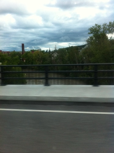
On September 30 and October 1, heavy rains affected much of the east coast from North Carolina to Vermont. In eastern North Carolina the rains were extremely intense, and some areas received more than 20 inches of rain! The rain was not quite as severe as that in Vermont but most areas still received over 3 inches of rain (there were around 3 inches of rain in Burlington, 4 in Middlebury, and around 5 in Rutland, for instance. Christopher Bert, an extreme weather expert, has named this rain event 'Super Rainstorm Nicole' because it was in part fed by short-lived Tropical Storm Nicole. Visit this blog for more info on this storm and its similarities to rainfall associated with Hurricane Hugo in 1999.
The storm caused widespread minor flooding in Vermont, but a major disaster was avoided, probably in part because most of September was rather dry. Nevertheless, the rivers were filled to the brim by this rainstorm. Here's what Otter Creek in Middlebury looked like on Friday morning:

The storm caused widespread minor flooding in Vermont, but a major disaster was avoided, probably in part because most of September was rather dry. Nevertheless, the rivers were filled to the brim by this rainstorm. Here's what Otter Creek in Middlebury looked like on Friday morning:
Wednesday, September 29, 2010
Flooding Rains Still Possible in Vermont
Just as a quick update, flooding rains are still in the forecast for Vermont and other areas of the East Coast tomorrow. A tropical storm is expected to quickly form, and then zip north from South Carolina bringing heavy rain along its path.
*** note: images removed because they no longer are relevant - NWS has updated/changed the links. More info on the storm soon.***
These storm systems are small in size and hard to predict so this is not an easy forecast. Needless to say, however, anyone from New York State south to South Carolina should be ready for the possibility of some very heavy rain.
I am hoping the downpour (if it happens) doesn't ruin the fall foliage!
Monday, September 27, 2010
Rainy times in Vermont
Rainy times have come to Vermont. After a relatively dry late summer, fall is arriving, and is bringing copious rain. As I type this it is raining outside, and it has been for most of the day. It will be raining on and off for much of the rest of the week too, and if some computer models are correct, it could be very rainy indeed.

Subscribe to:
Posts (Atom)