
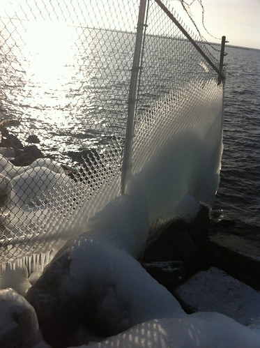
The air temperature has been below freezing for most of December, but Lake Champlain is large and deep, and the wide portion of the lake near Burlington, Vermont has not frozen over. The splashing waves deposit ice on everything near the lake, including branches, rocks, and even fences.
Click below to take a virtual tour of my walk, using Project Noah.
The Project Noah app allows you to photograph animals, plants, and other organisms you encounter, and upload them to a website along with their GPS coordinates. This gives anyone an opportunity to share what they find during hikes and everyday journeys. There are 'missions' included in the app, such as one for documenting squirrel behavior, one for documenting mushroom occurrences, and one for documenting urban nature. In this case, I was walking around near an old overgrown dock, a beach, a wetland, and a forested hillside.
I've lived in this area for over a year but this was the first time I explored this particular area, even though it is less than a mile from my house! I documented a random sampling of plants and animals (and signs of animal presence) that caught my eye. This was a bit difficult to do because it was 34 degrees with a cold wind blowing off the lake, so I spent a lot of time warming my hands in my pockets (the Iphone touch screen doesn't work with gloves on.)
Everything I documented today (and anything I document in the future using this app) can be found here. As of right now it is not possible to directly embed the map of my journey in this blog. but if you go to http://www.networkedorganisms.com/ , click on the 'maps' tab, and enter 'Burlington, Vermont' as the location, you can view what I found on a map. (No one else from Burlington has used the app yet, so every occurrence in that area was uploaded by me). Hopefully lots of people will use this app over time and it will be possible to take a virtual tour of different areas and see what sorts of natural features occur there. I'd like to see an option for water-related features as well... but after all the app is in its development phase, so this may pop up in the future!
Since there isn't yet a feature for interesting hydrological features, I photographed the ice formations on my own. Here are some of my favorites...
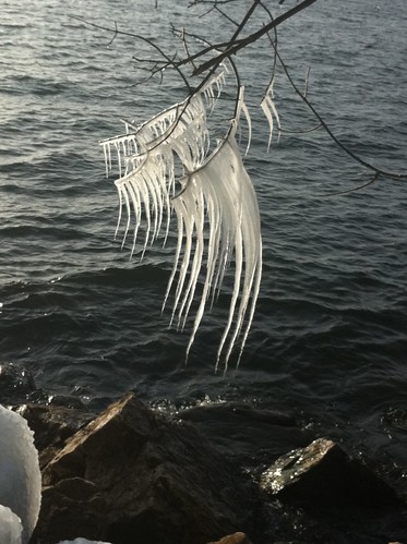
I think as the ice weighted down the branch, the icicles were tilted to the right. They continued to grow straight downward, resulting in a curve as weight increased.


All of the rocks near the water were covered in ice.

Some of the rocks had dozens of intricate icicles on their undersides.
As i alluded to earlier, there is a thaw on the way. Winter thaws tend to ice over or completely melt the snow, but they also offer a respite from the severe cold of winter, and bring some flowing water back into the landscape. I'll have thaw photos soon if it indeed comes to pass.
No comments:
Post a Comment