
The ability of life to survive and thrive in harsh environments is stunning and incredible. Many offer examples of 'extreme' environments that teem with life, such as deserts and the Arctic. Instead, I offer a place that is in many ways even harsher - and that has given life much less time to adapt to it - and still supports an ecosystem struggling to survive.
View Larger Map
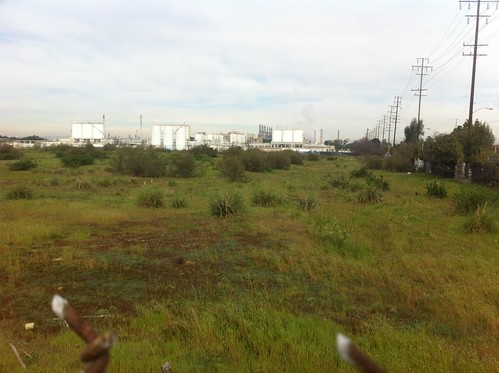
The map above could be a scene from many places in coastal California. The white shrub is almost certainly a flowering coyote brush plant. Around it is a disturbed landscape, but certainly not a heavily-manicured suburban expanse.
Now, please begin zooming out using the map above. As you do so, take note of natural features you see.
Keep going. After zooming out several times, you will see Madrona Marsh, about a mile to the southwest. That little city block is the only 'sizable' patch of open space in Torrance, and the likely subject of a future post. As you zoom out further you can see Palos Verdes beyond Madrona Marsh... an area of hills that supports a few fragments of native vegetation amongst the mansions. As you continue to zoom out you eventually can see the Santa Monica Mountains to the north, the Santa Ana mountains to the east, and Catalina Island to the south - much larger, though still threatened, patches of open space. The nearest intact 'wildland' - an area wild enough to support bobcats, mountain lions, and wild canyons of oak and sycamore - is the 'Big Wild' around Topanga National Park, 18 miles of urban sprawl to the north-northwest.
So, is this little piece of land a plot of forgotten 'intact nature' that somehow was spared development? Nope! Quite the opposite, it WAS developed, and then later abandoned.
Here's the Google Earth image from 1994:
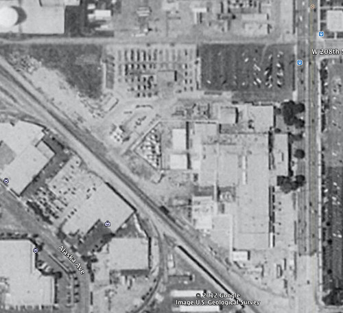
There's a large building and parking lot, and some sort of industrial complex.
In 2002:
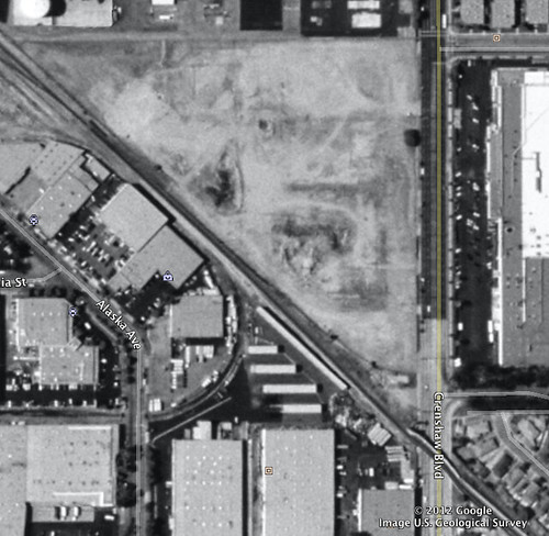
The structures are gone but there is no significant vegetation on the site.
On January 9 2005, when this photo below was taken, the area was apparently experiencing a short respite right in the middle of the wettest 15 day period in recorded history. What happened? The area filled up with water!
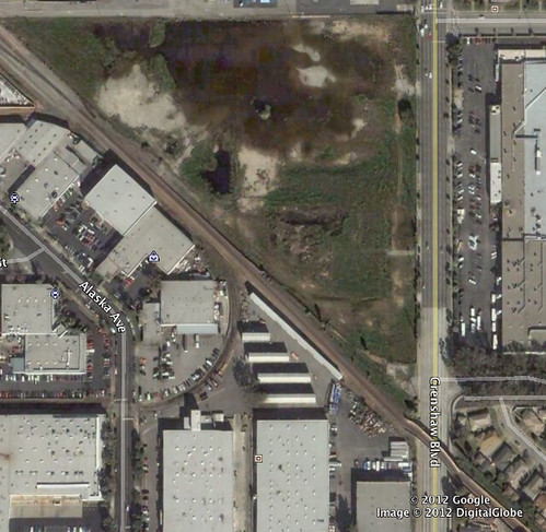
It's hard to say if this exact spot historically contained wetlands, but certainly the greater area included a diversity of wetland habitats before it was developed. Either way, in 2005 some sort of post-industrial vernal pool had formed onsite. Whether the body of water had a natural precedent or not, I remember seeing birds using the site as habitat during one of the times it had water pooled in it. The LA Creek Freak blog has a post about the historic wetland that once was found in this part of Torrance - unfortunately (trigger warning: ) the history of the place, including the name of the wetlands, holds a disturbing story of racism. It does appear that an arm of this slough once extended near this area.
A few weeks ago, when I was on Torrance, I went on a visit (and brought my mom along) to see what I could learn about the current state of this land. We first learned that we couldn't go in:
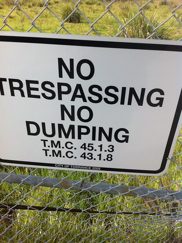
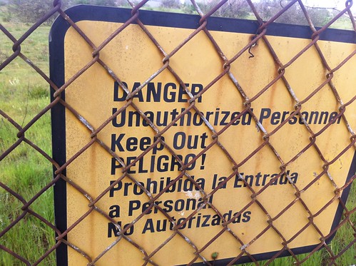
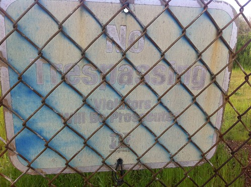
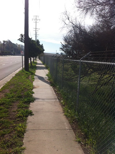
Still, there was a sidewalk nearby and it was easy to peek through the chain link fence.
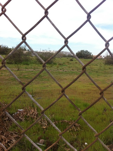
What I found was an odd mix of plants. There was a scattering of mule fat and coyote brush - two very hardy native plants. Fountain grass and pampas grass were also scattered around the site. In many settings these two plants are considered highly invasive but here, even they struggled with the harsh conditions of the site, and they didn't seem to be crowding out the native plants, which were holding their own. In the understory was the common mix of introduced, weedy annual plants such as ripgut brome, various sorts of filaree, and smilo grass.
All in all, I found 19 species of plant just from looking through the fence (click here for iNaturalist map and listing). Not included here is what may be a couple of arroyo willows, struggling to survive in the wetter part of the field, but possibly dying back. All in all, the site seems to have formed a post-urban sort of alkali wetland edge/vernal pool complex.
There was no visible pooled water when I visited the area, because it has been a dry winter.
I know nothing of the history of this site, and no idea why it has been left undeveloped, but I suspect it may be due to soil contamination, because the area has had a long industrial past and nearby areas have been contaminated by toxic waste. My parents also didn't remember anything specific about the land's history. I also have no idea how so many types of plant found their way to the site. Perhaps their seeds blew over from Madrona Marsh, or flew in attached to the legs of the birds stopping by in the 'vernal pool'. Maybe construction equipment or fill soil brought the seeds, and maybe some of them even survived in the soil over the years and germinated when given space to grow. Perhaps the goats brought in by the City of Torrance to 'control the vegetation (unfortunate, but considering the chemical plants and refinery nearby, a grass fire would be very very bad) brought in seeds. In the long term, I'd imagine the site will be developed again, or at 'best' turned into a manicured park of heavily irrigated lawns. Still, in the even longer term, perhaps some of the tough plants that have colonized this site have produced seeds that may find a foothold in equally harsh environments nearby, and thrive due to the adaptations their predecessors developed in this site. In the longest term everything is temporary, even our cities. I'm sure the coyote brush and black mustard will outlive the city in the end.
Does anyone know more of the story behind this little lot? If so, please leave a comment or email me!
Update: Thanks to Jessica Hall of the LA Creek Freak blog I have learned that this site is the proposed location for the new Green Line South Bay Transit Center. So, the mule fat's days may be numbered. How does one choose between mass transit and open space? Are there better places to place this transit center, or could a bit of nature be preserved alongside it? I will look into these questions in a further post.
No comments:
Post a Comment