
In the weeks since East Middlebury experienced flooding caused by Tropical Storm Irene, I've been watching a geologic and hydrologic event in progress on the Middlebury River.
When rivers flow through relatively flat areas, they tend to meander. Meanders grow in size as the river erodes away the 'outside' part of the bend (the side that momentum directs the water towards) and deposits sediment on the 'inside' part of the bend. Over time, the meanders become more and more convoluted, until the meander grows so large that it cuts back towards itself. The river then shifts course to 'cut off' the majority of the meander, often leaving a lake or wetland in the abandoned river channel.
The meanders are called oxbows, and are commonly found on natural, slow-moving watercourses of all sorts. There is a good description of the process here on Wikipedia.
Below is a Google aerial photo of part of the Middlebury River (not the part I have photos and drawings of, but in this area it is easier to make out the river bends).
View Larger Map
You can see many bends including one that has recently cut off, which is at lower right.
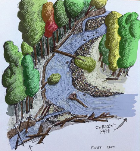
With the bend near my home, Irene was able to ALMOST cut through the bend, but didn't quite finish the job. On the upstream side, the bend cut towards west, and on the downstream side of the bend erosion from water that spilled over the flood plain began eroding backwards and creating a new channel. The result was a small new branch of the river that cuts across the 'neck' of the bend, with a deep pool in its upstream portion, and a chunk of dirt about 30 feet long that keeps the main force of the river out of its potential new channel... for now.
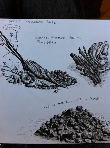
Below is a sketch I made to illustrate the current status of the cut. The river flows from the background and bends towards the right, and on the lower left you can see the new river path forming.
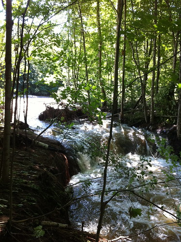
Here's a photo of the new channel, taken when the river was still running very high after Irene:
After several dry days, the water has dropped a lot in the river, but even when the river is low there is a small amount of flow in the channel:
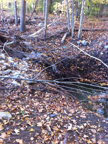
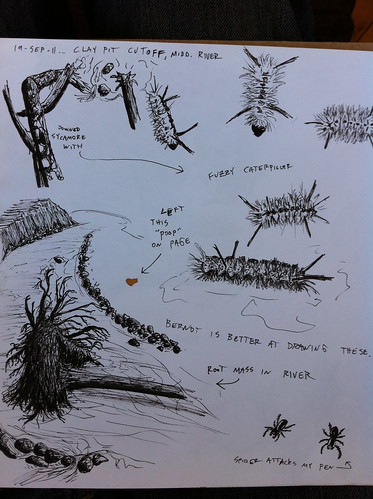
Notice all the tree roots in the eroding area. They are doing an excellent job of holding the soil in place, and since the river has not risen much since Irene, very little additional erosion has occurred here. I think it will be surprisingly resilient to erosion, but I think the next big flush of water (perhaps the spring thaw) will probably cause most or all of the river to divert down this path.
See here for an album of photos. I'll be adding more over time.
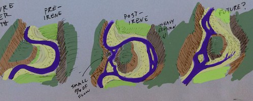
Here's an illustrated overview of the oxbow cut:
Here are two more sketches from that day:
I'll keep watching the oxbow. Hopefully I can catch it right after it breaks and get good photos of the river in action! Further forward in time, the abandoned stretch of river will turn into floodplain forest, and will continue to absorb and slow down floodwaters and act as a filter to remove sediment from the river.
Very good article and I'm off to work so will comment on a later time.
ReplyDeleteThanks again - Kevin
Storm Irene was from August 2011 - what's the current status of this oxbow?
ReplyDeleteThe oxbow did not cut completely but over 10 feet eroded away and perhaps more importantly it has eroded back beyond the root ball of the sycamore that was reducing erosion. It's only a matter of time now and will probably burst through with the next big rain, whenever that is. I'll probably have a post about it this weekend.
ReplyDelete