
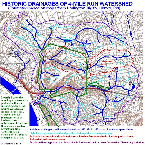
This map is inexact, of course, due to the changes in road locations over the years and just general accuracy issues (some of the old maps did not appear to be quite to scale). It gives a good idea of what the area was probably like in the past though. The dark blue streams are those that I found on the maps, and the light blue streams are additional places where water may have flowed based on the topographic map. The purple line delineates the approximate historic 4-mile run watershed, and the red line delineates two parts of the Panther Hollow watershed. I'll talk about what a 'beaheded stream' is later, in another post. The green line delineates areas of mostly natural vegetation - most of the creeks in these areas are still partially intact, except the western branch of 4-Mile Run at the far western edge of the map (more on this later too!)
So, now what? My plan for this weekend or next week is to get out there and look for evidence of some of these old channels! Most of them will be ineligible for restoration ('daylighting') due to the density of the city around them. The western portion of 4-mile run was put underground in the early 20th century when the creeks ran with raw sewage. In that state, the creek was a health risk and was buried. Now that things are a lot cleaner, there is a plan to 'daylight' a portion of this creek, if funding and political support are obtained. I'll post more about this later, too.
No comments:
Post a Comment