
Why the uncertainty? Well, as is often the case, the computer models we use to forecast the weather don't agree on what will happen.
Tropical Storm Sandy has formed way south in the Caribbean, and is moving north. It will probably strengthen into a hurricane and cause damage in Cuba, Haiti, and the Bahamas, before continuing north. After this point...
The two main weather models that offer forecasts 8 days out are the ECMWF, or Euro, and the GFS.
Here's what the Euro forecasts for next Tuesday (from Wunderground):
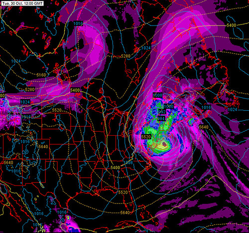
Yikes! It actually looks a bit like a colder Irene. Though, it's important to note that it would be converting to an extratropical storm. It wouldn't still be a hurricane. This might mean a less rainy and windy storm, but also means:
Yep. That's snow. If this were exactly correct Baltimore could pick up some snow, and Buffalo would be buried. It won't be exactly right though, no matter what, because this is seven days away. If there is any snow, it could occur just about anywhere in the Northeast, but won't occur everywhere.
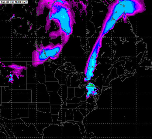
OK, so the Euro model forecasts a big storm. What does the GFS indicate?
No Nor'easter there. Northern Vermont might get some flurries, and northeastern Maine some heavy rain... but nothing extreme. Instead of forming into a nor'easter, Sandy would wander off to sea.
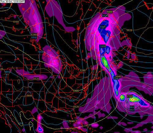
So which model, if any, will be correct? It's far too early to say. I think the Euro has been a bit more accurate than the GFS lately. Then again, the GFS pretty much nailed Irene's Vermont impacts over 100 hours before it happened. There's also a GFS 'ensemble' that runs a model several times with slightly varying starting conditions. About half of the ensemble members had the storm making landfall somewhere in the northeastern US, the other half had it going off to sea.
So either option is probably equally likely. If the storm does hit, the areas east of the low center would likely have the heaviest rain and strongest wind, while areas to the west would have the highest chance of picking up heavy snow. It's far too early to speculate where each could occur with any accuracy.
So... it's definitely not worth worrying about, but it's worth checking to make sure you have extra supplies and are prepared to weather a serious fall storm. This storm may miss, but it's nearly certain that a significant nor'easter will come up the coast at least once or twice this fall or winter, so it would be good to be prepared.
A hurricane combining with or turning into a nor'easter sounds a bit like science fiction, but it's happened in the past. Not surprisingly, it can result in a very serious storm that combines the wind and moisture of a hurricane with the vast size and wintry potential of a nor'easter. In 1804, the Snow Hurricane occurred when a hurricane converted to an extratropical storm and pulled in cold air on its northern and western sides, resulting in extremely heavy snow over most of New England in mid October. The Perfect Storm of 1991 was a hybrid between a hurricane and a nor'easter that formed when a nor'easter absorbed Hurricane Grace and then followed an unusual wandering path over the Gulf Stream. Incredibly, it actually formed a small new hurricane at its core, and became a monster storm that caused damage and loss of life along the US and Canadian East Coasts. Later it was remembered in the well-known movie describing the loss of a fishing boat that was unable to weather this storm.
Regardless of what happens next week, both the results of these computer models and a look back at these two intense winter storms remind us of the intensity and scope of storms that sometimes strike the eastern portion of North America.
Nice intro and analysis, Charlie.
ReplyDeleteMaybe this is a good time to see how Vermont's disaster management process has learned from Irene.
Thanks! Sandy is still out there! Right now it looks like a mid-atlantic landfall with very strong winds and heavy rains for a heavily populated part of the East Coast... in Vermont perhaps not flooding rains, just a windstorm and not as bad as to the south. But, that could change between then and now!
ReplyDelete