During a year of some of the worst flooding the United States has ever seen, spanning just about every state except those in severe drought (such as Texas), the US federal government is planning to shut down 376 stream gages due to 'lack of funding' (Thanks to @wunderground on Twitter for this link). Apparently, a USGS stream gage costs around $15,700 a year to maintain, a minimal sum when compared to its benefits. Stream gages allow for accurate flood warnings, that save lives, livestock and property... allow for flood plans to be estimated more accurately... and provide information on water supply during times of drought.
I'm trying not to get into politics too deeply here, since it is a contentious issue and I feel that this is a non-partisan issue and need. But, when I think about other things our government and economy expend money and resources on, and how tiny a speck the cost of a stream gage is in the grand picture, I am disgusted. Are human lives, or our homes and everything in them, or our, businesses, crops, and livestock that are our livelihood... not worth $15,700 a year in each of these watersheds? Are we, the people of the United States, unable or unwilling to demand that our representative government provide cheap and effective services that protect us from loss of life, or is the system so broken that the government is not at all representative of us any more?
There should be many more stream gages being installed, none being removed, and many more rain gages also being added in upper watershed areas.
If our government is unwilling or unable to provide stream and rain gages, I think we need to look into alternatives. Perhaps a citizen-science type network of people could be assembled who are willing to invest a lesser sum in an automated weather station (probably under $500.00 - perhaps with a tax rebate or grant?) or some form of 'cheap and dirty' stream gage. Perhaps state governments or private industry could step in (I know I keep mentioning Google, but I know they could be a part of this). If all else fails, we need a watershed/flood smartphone/computer reporting network (as mentioned before in this blog I am partial to the iNaturalist / whatsinvasive format). Even a normal webcam aimed at a $3 yardstick in the creek would be better than nothing (though it was just pointed out to me that it would be impossible to see at night, when floods are most dangerous!)
The VTResponse people are doing an amazing job and helping organize flood recovery in Vermont. Who is going to step forward to protect us from the next flood? We have great people at the USGS already willing to process the data and inform the authorities of imminent flooding... but they can't do that without having the data in the first place.

Stories about the ways water moves through natural and human-constructed landscapes... what we can learn from it and how we can use old and new ideas to understand, appreciate, and sustainably use this resource.
Showing posts with label Creeks and rivers. Show all posts
Showing posts with label Creeks and rivers. Show all posts
Friday, September 9, 2011
Tuesday, August 30, 2011
Middlebury River After Irene
After learning that East Middlebury largely escaped serious damage from the Irene floods, i set out to check on what had happened along the river. Like most areas of Vermont, the water rose higher than any of the residents I talked to remembered (I'm not sure how this area fared in the floods of the late 1920s). It seems that this was at least a '50 year flood' if not a '100 year flood'. (Note that these floods are named by their probability of occurrence, ie: a 100 year flood has a 1 in 100 year chance of happening. They don't necessarily happen every 100 years).
East Middlebury lies on a glacial delta that formed when glacial Lake Vermont filled the Champlain Valley. The river emerges from the mountains and changes from a steep, gorge-confined river, to a meandering, slow stream as it passes through East Middlebury. In the process, it drops sediment from the mountains. Larger rocks are dropped near the gorge, gravel and sand carried further, silt deposited in slow-water areas, and clay carried out of the area (and often all the way to Lake Champlain).
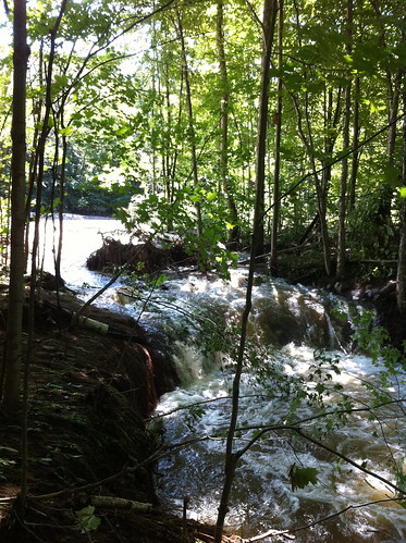
Anyway, back to Irene... the storm created a historic flood that had big effects on the river. But, in the rockbound gorge, very little changed.The gorge was at least in part cut when the river was much larger than now due to glacial dams diverting the New Haven River down its course as well. So, even this major flood is smaller than the floods that carved the gorge. While some rocks shifted, the river's course did not. It takes thousands of floods like this to carve a gorge like that, and it doesn't usually change very fast. See the comments on this post for more info on the glacial history of the area courtesy of Chris.
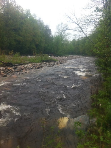
The river was RAGING the day after the Irene floods. I very carefully took this picture, making sure to avoid the banks of the river, which could have been eroded by the floods. If I fell into this, I'd be done for!
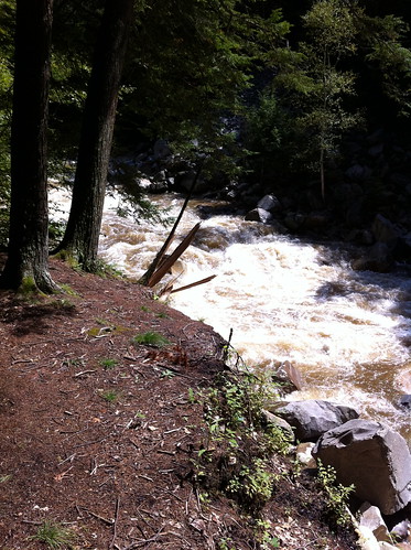
At the base of the mountains, the river passes through this even narrower gorge under the Highway 125 bridge:
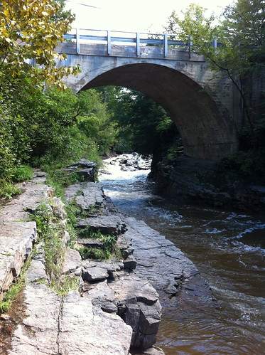
Sometimes we go swimming here, but not today. (Note: After Irene, do NOT dive into swimming holes, even in areas that have always been safe, without checking if it is still OK first. Irene's flood moved some enormous boulders and changed where sand and gravel bars are located... previously safe areas may be deadly to divers now.)
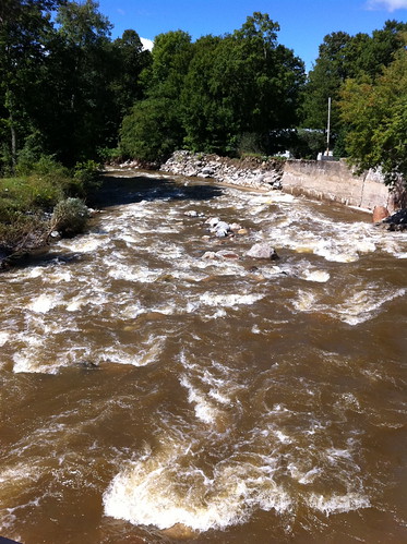
After leaving the gorge, the river slows down a bit and passes through town. Here's the river from Grist Mill Road, looking downstream. As the name implies, there was once a mill here. You can see the features in place to protect the town from the river. They have worked well for many years, but this flood was too much for them. Upstream from here, the river jumped its banks and ran down Highway 125 for a while, flooding basements and eroding driveways. Note that the river is still rather confined by its banks and these levees.
Between Grist Mill Road and Route 7, the Middlebury River drops a lot of sediment. Its course begins to wander, and sycamores and cottonwoods, rare in Vermont, line its banks. This part of the river is very dynamic, and changed a LOT during the floods.
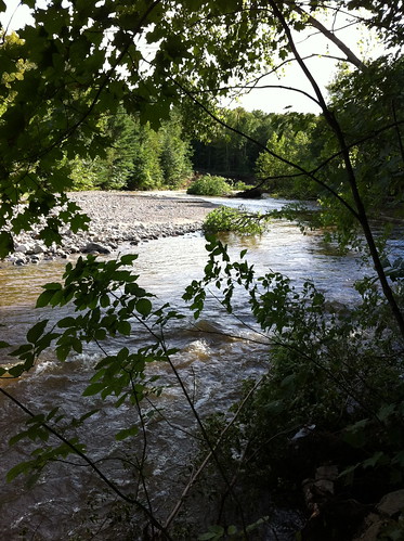
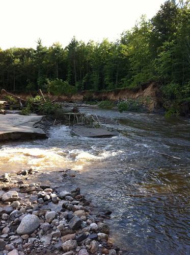
Both these areas are almost unrecognizable since the river has changed so much.
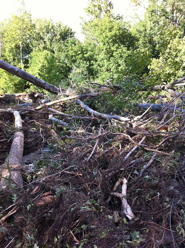
Trees from upstream are laying in piles everywhere. This looks like a lot of destruction, but trees in rivers provide habitats for lots of creatures, including trout and the species they eat.
Above, a side channel of the river erodes backwards towards the main stream. Eventually this channel may reach the main channel and 'steal' its water, causing the river to shift course. In this case, this happening would not endanger structures since it's in the undeveloped flood plain. The old river channel would become a wetland, then gradually fill in with cottonwood and sycamore trees. Over the thousands of years since the last Ice Age, this process has created a dynamic, diverse ecosystem along the river. The Middlebury Area Land Trust has obtained a conservation easement along part of the river in this section, which will allow the river to continue unrestrainted in its wanders.
Downstream from Highway 7, the Middlebury River has dropped most of its heavy sediment, and it slows down and meanders extensively. I didn't visit this section yesterday, because it was more heavily impacted by flooding and I didn't want to get in the way of residents dealing with flood damage. I'll visit the lower section of the river at a later date and see how it fared during the floods.
Here's a Google map of the Middlebury River at the gorge:
View Larger Map
Note: please respect private property rights and don't try to access the river through private property. There are places where you can see the river near the 125 and 7 bridges. The MALT parcel is not yet developed for public access, but may be in the future. This river is very sensitive to rainfall and rises fast during floods, so stay away from the river, especially in the gorge, during and after heavy rains!
East Middlebury lies on a glacial delta that formed when glacial Lake Vermont filled the Champlain Valley. The river emerges from the mountains and changes from a steep, gorge-confined river, to a meandering, slow stream as it passes through East Middlebury. In the process, it drops sediment from the mountains. Larger rocks are dropped near the gorge, gravel and sand carried further, silt deposited in slow-water areas, and clay carried out of the area (and often all the way to Lake Champlain).
Anyway, back to Irene... the storm created a historic flood that had big effects on the river. But, in the rockbound gorge, very little changed.
The river was RAGING the day after the Irene floods. I very carefully took this picture, making sure to avoid the banks of the river, which could have been eroded by the floods. If I fell into this, I'd be done for!
At the base of the mountains, the river passes through this even narrower gorge under the Highway 125 bridge:
Sometimes we go swimming here, but not today. (Note: After Irene, do NOT dive into swimming holes, even in areas that have always been safe, without checking if it is still OK first. Irene's flood moved some enormous boulders and changed where sand and gravel bars are located... previously safe areas may be deadly to divers now.)
After leaving the gorge, the river slows down a bit and passes through town. Here's the river from Grist Mill Road, looking downstream. As the name implies, there was once a mill here. You can see the features in place to protect the town from the river. They have worked well for many years, but this flood was too much for them. Upstream from here, the river jumped its banks and ran down Highway 125 for a while, flooding basements and eroding driveways. Note that the river is still rather confined by its banks and these levees.
Between Grist Mill Road and Route 7, the Middlebury River drops a lot of sediment. Its course begins to wander, and sycamores and cottonwoods, rare in Vermont, line its banks. This part of the river is very dynamic, and changed a LOT during the floods.
Both these areas are almost unrecognizable since the river has changed so much.
Trees from upstream are laying in piles everywhere. This looks like a lot of destruction, but trees in rivers provide habitats for lots of creatures, including trout and the species they eat.
Above, a side channel of the river erodes backwards towards the main stream. Eventually this channel may reach the main channel and 'steal' its water, causing the river to shift course. In this case, this happening would not endanger structures since it's in the undeveloped flood plain. The old river channel would become a wetland, then gradually fill in with cottonwood and sycamore trees. Over the thousands of years since the last Ice Age, this process has created a dynamic, diverse ecosystem along the river. The Middlebury Area Land Trust has obtained a conservation easement along part of the river in this section, which will allow the river to continue unrestrainted in its wanders.
Downstream from Highway 7, the Middlebury River has dropped most of its heavy sediment, and it slows down and meanders extensively. I didn't visit this section yesterday, because it was more heavily impacted by flooding and I didn't want to get in the way of residents dealing with flood damage. I'll visit the lower section of the river at a later date and see how it fared during the floods.
Here's a Google map of the Middlebury River at the gorge:
View Larger Map
Note: please respect private property rights and don't try to access the river through private property. There are places where you can see the river near the 125 and 7 bridges. The MALT parcel is not yet developed for public access, but may be in the future. This river is very sensitive to rainfall and rises fast during floods, so stay away from the river, especially in the gorge, during and after heavy rains!
Thursday, August 4, 2011
Vermont Summer Dry Spell
It's hard to believe after the soakings of this spring, but Vermont is in the midst of a summer dry spell.
This isn't an extreme drought of the sort that Texas is experiencing. It's quite normal for Vermont to have several weeks of mostly dry weather in midsummer. As is often the case, there have been at least a few thunderstorms in Vermont each afternoon, but they have been small and fast-moving.
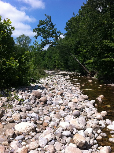
This dry spell isn't phasing the lush green growth in meadows and the forest understory that grew after this spring's rain. It is having an effect on the Middlebury River, though. With a steep, relatively small watershed, the Middlebury River is very sensitive to weather events in the short term. In fact, it reminds me a bit of the washes and canyons in southern California, with one key difference: even during dry periods, the Middlebury River is always flowing. Most rivers and streams in southern California are dry this time of year, especially in areas with wide, cobbly or sandy riverbeds, like the part of the Middlebury River I most frequently visit.
Here's one part of the river, as it looked about a half hour ago:
Here is how that same area looked during the May floods:
The view isn't from the exact same place, but note the leaning sycamore in both pictures. Note that this is also not the entire flow of the river, as this area has more than one river channel (typical of rivers that are full of cobbles and have a medium gradient). Even still, it really shows how the water level has changed.
The picture also demonstrates how amazingly fast cottonwoods and sycamores grow. Those large saplings to the left are the same trees as the little seedlings in the first picture! When the land you are growing on washes away in floods every few years, you have to mature and set seed fast!
More pictures below:
This isn't an extreme drought of the sort that Texas is experiencing. It's quite normal for Vermont to have several weeks of mostly dry weather in midsummer. As is often the case, there have been at least a few thunderstorms in Vermont each afternoon, but they have been small and fast-moving.
This dry spell isn't phasing the lush green growth in meadows and the forest understory that grew after this spring's rain. It is having an effect on the Middlebury River, though. With a steep, relatively small watershed, the Middlebury River is very sensitive to weather events in the short term. In fact, it reminds me a bit of the washes and canyons in southern California, with one key difference: even during dry periods, the Middlebury River is always flowing. Most rivers and streams in southern California are dry this time of year, especially in areas with wide, cobbly or sandy riverbeds, like the part of the Middlebury River I most frequently visit.
Here's one part of the river, as it looked about a half hour ago:
Here is how that same area looked during the May floods:
The view isn't from the exact same place, but note the leaning sycamore in both pictures. Note that this is also not the entire flow of the river, as this area has more than one river channel (typical of rivers that are full of cobbles and have a medium gradient). Even still, it really shows how the water level has changed.
The picture also demonstrates how amazingly fast cottonwoods and sycamores grow. Those large saplings to the left are the same trees as the little seedlings in the first picture! When the land you are growing on washes away in floods every few years, you have to mature and set seed fast!
More pictures below:
Monday, November 22, 2010
Neat Iphone App for Monitoring Watercourses: "Creek Watch"
I just learned about a very neat app from the LA Creek Freak blog.
The CreekWatch app, developed by IBM, allows you to take photros of a creek and report the amount of water and whether or not there is any trash present.
 (picture from the Iphone App Store)
The CreekWatch app, developed by IBM, allows you to take photros of a creek and report the amount of water and whether or not there is any trash present.
Wednesday, November 17, 2010
Panther Hollow Run Watershed Map on Google Maps!
Remember the Historic Channels of Squirrel Hill map I made last summer? I've made a draft version of this map that is viewable on Google Maps!
View Panther Hollow Lost Channels V1.0.kmz in a larger map
(Be patient, it can be slow to load.)
The dark blue lines are existing watercourses, the light blue lines are historic watercourses I found on old maps, and the yellow lines are places where I think surface water once flowed, based on hydrology, but did not see on historic maps. The light red outline is the current Panther Hollow Run watershed and the maroon line is the part of the watershed that drains into the combined sewer-stormwater system. There are a few other features thrown in too. Click on the features on this map for more info.
Over time I hope to expand this map over the whole Four Mile Run watershed and add other features. Ultimately it will hopefully expand to be a big part of the outreach I am working on for my project.
I am currently looking at ways to get this on the version of Google Earth on 'smartphones', so that people can actually pull up this map while in the watershed and see where historic channels are. Stay tuned...
Thursday, October 21, 2010
More about Beavers in Southern California
Beavers have been on my mind lately, as evidenced in the long post I made about them yesterday. As mentioned in that post, beavers have huge positive effects on watersheds, and their removal has caused drastic effects that we can't even understand the full effects of. I have wondered if beavers were present in some of the more protected perennial streams (or streams that would be perennial with beaver meadows) of southern California. In fact, today I found evidence that in fact beavers did inhabit at least one more wild southern California stream.
Wednesday, October 20, 2010
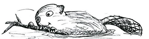
The Beaver: Our Slow Water Animal Ally
Us humans sure have an inflated sense of importance! Since we are the ones who created pavement, rooftops, and channelized culverts, we think we are the only ones who can also work to slow down water with rain gardens, bioswales, and constructed wetlands. It's time to face up to the truth. There is another mammal who has been constructing wetlands and 'rain gardens' since long before humans even set foot in North America. In truth, they do a better job of it than us, too. Unfortunately, humans have done a good job of driving these animals away from much of the United States in the last 500 years. The good news is that they are already on the comeback, and all they ask in return for their work is a little bit of space, tolerance, and some delicious aspen and willow to chew on.
Wednesday, October 13, 2010
A Pond of Two Watersheds
Although there are many sub-watersheds within every watershed, it is very rare for an area to be part of more than one watershed. Water that falls on the Earth and flows downstream generally has only one possible path to follow as it flows downhill (unless it evaporates or is used by living organisms). In particular, it is quite unusual for a pond to drain into two watersheds. For this to happen, the pond has to be right on the peak of a drainage divide! (If you think of a watershed as similar to a tree, a pond draining into two watersheds would be like a single apple growing on two trees at once). However, in Vermont, there is a pond called Sterling Pond that is perched right on the main divide of the Green Mountains! Water from this pond flows both into the Winooski River (via the east side of the mountain range) and the Lamoille River (via the west side of the mountain range).
![IMG_0428[1]](http://farm5.static.flickr.com/4018/5079207608_d7e1fb6b65.jpg)
Subscribe to:
Posts (Atom)