Winter is still several months away, but with trees starting to turn color, squirrels hoarding acorns, and geese starting to act restless, people are starting to talk about what the next winter might hold. A week or so ago my girlfriend was at a farm in a cold part of rural Vermont and a local resident pointed out a woolly bear caterpillar and noted that the abundance of brown fuzz on the caterpillar might mean that a cold winter was on the way.
I've heard elsewhere, though that more brown fuzz indicates a milder winter, or that more fluffy fuzz means more snow. I'm more inclined to trust the local knowledge, but at the same time, the caterpillars aren't sending a clear message, at least not one I know how to read.
The maple trees are sending a less ambiguous message. Regardless of whether it is warmer, colder, snowier, or drier than average, colder weather is on the way, and soon. Even a slightly warmer than average Vermont winter can see significant periods of subzero weather.
But what are other people saying? Well, the Farmer's Almanac predicts 'cold and snowy' for northern New England, but most Vermont winters are 'cold and snowy' by overall US standards, so I'm not sure if they are calling for an especially snowy year, or just the normal cold weather we get every year. The Accu-Weather forecast does not mention anything in Vermont at all, which I suppose is a forecast for a normal winter, but does mention later in the forecast that weak to moderate El Ninos like we may be having tend to bring snowy weather to New England.
Last year, both the Accu-Weather and Farmer's Almanac called for a very cold and snowy winter in Vermont. As anyone here will tell you, it was an extraordinarily snowless and mild winter compared to normal. (though the Accu-Weather forecast for 2010-2011 called for heavy snow and indeed it was the second snowiest year on record in much of Vermont. I suppose the Accu-Weather forecast is a bit like a broken clock that is right every time it snows a lot.)
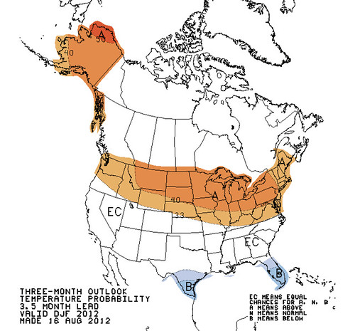
NOAA made a rather vague forecast last year - somewhat above average precipitation, and an equal chance of warm, cold, or average weather. The precipitation was below average and the temperature above average. This year the current forecast as of early September (they are updated fairly often) calls for above average temperatures and has no precipitation trend forecast in Vermont (but perhaps stormier than average conditions along the New England coast). Note that this forecast simply says that there is a 40% chance of above average temperatures, and a lower chance of colder than average or normal temperatures. This is averaged over the entire time period, and doesn't mean some periods couldn't be very cold. And of course, the forecast could just be wrong, like they all were last year.
Above: NOAA temperature forecast for December 2012-February 2013. See the link above for more maps.
I'm not going to make a winter forecast for Vermont this year, because I don't think there are any strong signals one way or another. I will note that overall monthly temperatures have been above average for a very long time - I think over a year - so unless there is a significant pattern change we can guess that it may be a bit warmer than average. In addition to current jet stream patterns the climate of the whole globe is warmer than in the recent past, causing an increased likelihood of warmer temperatures overall. BUT, somewhat paradoxically, the warming has melted much of the sea ice in the Arctic, and there are indications that the lack of Arctic ice can move the jet stream and actually lead to blizzards and Arctic blasts over places like Vermont. Similar phenomena were documented in several Northern Hemisphere areas over the past few years, including last year (just not in the continental US that time). So... it's possible our string of warm conditions will be interrupted by a harsh arctic blast of the kind we haven't seen in many years.
So all I can say for sure is it should be interesting. I will say that I have seen indications that the Vermont oaks are possibly 'concerned' about a future weather event, though it may be that the indicator I use to monitor this (which seems to correlate with California drought) may just have been triggered by the dry summer. We'll see!
For those of you in California, the climate indicators are much more strong this year. We're probably heading into a weak to moderate El Nino, and as many people already know, El Nino tends to correlate with above average, sometimes torrential rain in southern and central California. Not all El Nino years are wet, but averaged over all the El Nino years we have records for, the average precipitation in California is much higher than non-El-Nino years. Hopefully California will see some drought relief, and perhaps Texas and Florida as well.


No comments:
Post a Comment