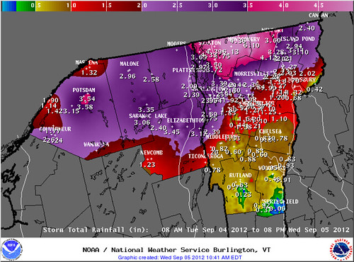
If the weather forecasts for a few days ago, the headline for this post could have been Isaac's Remnants Selectively Soak Southern Vermont... which would have sounded better, with alliteration and all. That isn't what happened, though. The low pressure area containing copious moisture from the remnants of Hurricane Isaac made a last minute jog to the north. Anyone north of a line from Virgennes to Saint Johnsbury got soaked, while those to the south of that line experienced a run of the mill late summer storm. The Adirondacks got a drenching as well, and apparently also southern Quebec, though I don't have precipitation figures from there.
Burlington picked up more than 3 inches of rain last night, the most it's seen out of one storm since Irene came through last year. Some of the northernmost parts of Vermont picked up more than six inches of rain! Here in Montpelier we were right on the edge of the heavy rain, and we picked up between an inch and 1.5 inches of rain overnight.

Above: Estimated and reported precipitation amounts courtesy of NOAA. Unfortunately the map is a bit jumbled but you can pick up the trends...
The North Branch of the Winooski has risen, though not dramatically so, because it has been so dry. Further north, where heavier rain fell, river raises were more dramatic with the Missisquoi River raising almost EIGHT FEET overnight! It actually rose a bit over flood stage in Troy. I haven't heard of it doing any damage, but it's certainly an unexpected event in this otherwise dry summer.
For most of Vermont, and indeed most of the areas affected by Isaac, the rain was welcome despite the problems it caused.
Meanwhile, way out in the Atlantic, Leslie has fought off wind shear and has become a hurricane. Leslie isn't going to hit New England as was previously considered a slight possibility, but is likely to seriously impact far eastern Canada. By traveling north and strengthening, it will slow down a front passing over Vermont this weekend, perhaps contributing to another storm somewhat similar to the one we just had. Since most areas picked up heavy rain this time, we need to watch out for possible flooding this weekend. Fall is building in, and it's certainly a change from the dry summer we've been having.
Incidentally, it isn't only the eastern half of the United States being impacted by moisture from dissipated hurricanes. Scattered showers from a tropical remnant are also affecting much of California. Rainfall totals have been very light, but this is still the dry season, so any precipitation is unusual. There is also the chance of dry lightning that could cause fires.
As fall builds in, people have begun talking about winter, especially here in Vermont where winters can be so dramatic. I'll have a post about some of the winter forecasts being thrown around, soon.

No comments:
Post a Comment