I spent a lot of time working on a new project today, and while it isn't directly related to watershed issues, it is related to technology and natural science so I thought I'd mention it here.
I've posted before about iNaturalist, a website and smartphone app that allows people to upload sightings of different living things found in nature, along with photos and location (located by GPS in the case of smartphones). There are a lot of neat potential applications for this program, and I decided to set up a project to help gather data on the organisms living around Middlebury, Vermont; especially land managed by the Middlebury Area Land Trust and/or along the Trail Around Middlebury.
This project allows anyone who downloads the iNaturalist app or registers for the website to upload sightings found in the area. I haven't gotten anyone else involved in this project yet, but I've been doing informal surveys of the vegetation when on solo explores, and have gathered quite a bit of data. You can see what I've found so far by visiting the project website here. While you can't view all the data at once, you can view up to 200 occurrences at once at this link, or navigate to a particular location and refresh to get data on a more local level. Yet, this data is only the tip of the iceberg compared to what is possible using this program. If I can get a few students at Middlebury College or a few of my friends into using this program, we can gather a nearly unlimited amount of data - and with the photo and GPS capability with smartphones, even people who aren't sure of IDs can participate.
One of the funnest parts of this project is that it is possible to create range maps of different species in the area (and throughout the continent if enough people participate!) For example, you can see locations of white pine here (this is a very common species - it's really everywhere - but that means I've documented it many times)... you can see the distribution of white oak (a more restricted species in Vermont) here, and you can look for occurrences of invasive Glossy Buckthorn here (though I have also mapped some on What's Invasive and may make a new 'park' for this area also).
I've also included a Google map below. Note that it is a work in progress - for some reason it is not displaying the occurrences in Battell Woods and I haven't yet figured out why.
View iNaturalist MALT Project in a larger map

Stories about the ways water moves through natural and human-constructed landscapes... what we can learn from it and how we can use old and new ideas to understand, appreciate, and sustainably use this resource.
Tuesday, November 29, 2011
Sunday, November 27, 2011
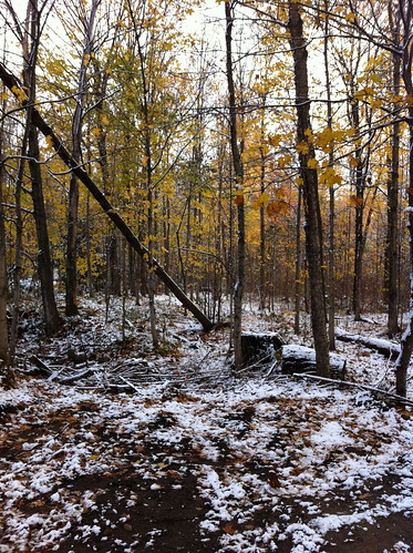
A Few Cold Days in a Warm November on the Middlebury River
This November has been a warmer than average one so far in Vermont. The temperature has been above 50 on quite a few days, and many overnight lows have been above freezing. The warm weather wasn't consistent throughout the month, though. Earlier this week we had a cold snap - with temperatures in the mid teens - followed by several inches of wet snow.
Monday, November 21, 2011
A Cold Autumn Visit to the Lower Middlebury River
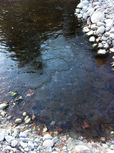
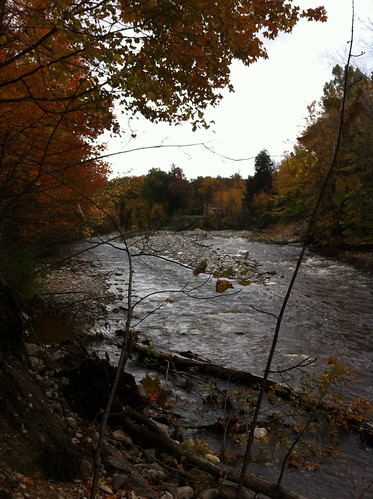
This November has been an unusually mild one in Vermont so far, but today was an exception. Despite clear skies, the temperature never made it out of the 30s (and now that the sun has set, it is dropping fast). I decided to take a visit to the lower Middlebury River on my way in to town today, because I'd heard news that the City (make that town) of Middlebury was planning to remove some logs from this section from the river, and as I mentioned in the past, this is not always a good idea.
Click below for what I found.
Click below for what I found.
Thursday, November 17, 2011
From Mammatus to Graupel: This November's Wandering Vermont Weather
After a soaking wet and seasonably cold October with a few frosts and some light snow, the onset of November brought an odd weather change to Vermont. The weather dried out, the sun came out, and warmer than average conditions spread over the state.
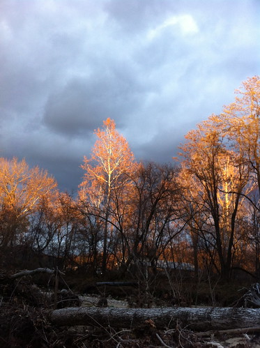
Above: sun lights up bare deciduous trees along the Middlebury River as it peeks through a gap in the clouds low on the western horizon. You can't see the river from this photo, but the water level is the lowest it has been since before Irene.
Monday, November 14, 2011
Over The River: Can Waterway-Themed Demonstration Art be Harmful?
If you drive north from Los Angeles on Highway 5, you drive through a remarkable pass. After meandering upward past the Santa Clara River and hillsides of chaparral, you enter a wide valley, a 'triple-point' of sorts where the Mojave Desert, the chaparral-covered coastal mountains, and the foothills around the Central Valley all come together. After cresting the Tejon pass at just over 4000 feet of elevation, you plunge into an extremely steep and narrow canyon known as 'The Grapevine' - both because wild grape vines carpet the canyon walls, and because the road itself twists up the canyon like a giant vine. Approaching the area from the north at night, from the flat Central Valley, the row of taillights ahead appears to ascend, in a wide bend, straight into the sky.
A lot of people funnel through this pass every year, and the passage isn't easy. The wide Central Valley to the north creates a giant funnel, channeling not only travelers, but also north winds, straight into the pass. Winds near hurricane force are not uncommon in the winter. Clouds often form as the air rises over the pass, creating dense fog. Worst of all, because the pass captures winds and moisture from the colder north, blizzards often rage on the north side of the pass, even when Los Angeles, 50 miles to the south, is sunny and warm. Meanwhile, in the summer, dry heat from the Mojave Desert and Central Valley build in, leading to temperatures well over 100 degrees, and dozens of overheating cars on any summer day. Because of the unique climate, blue oaks and buckeye trees normally found further north grow on the north side of the pass, while a few miles to the south Joshua trees are clumped in the gullies. It is a place of convergence, but not a gentle place. Even today, passing through The Grapevine can be treacherous, and the pass is known for its road closures and chain-reaction accidents.
The pass is a prominent and important place, and in 1991, two artists - Christo and Jeanne-Claude - decided to fill the pass with giant umbrellas as part of a giant art exhibit. The effect was visually fascinating, but I can't help but speculate that if the artists thought this was a good idea, they had never tried to drive through this pass during a winter storm. Sure enough, by late October a windstorm swept into the area. One of the umbrellas was ripped from the ground and tossed at several people looking at the art exhibit... and a woman was crushed and killed by the umbrella.
Christo is now planning to stretch 7 miles of fabric over the Arkansas River in Colorado.
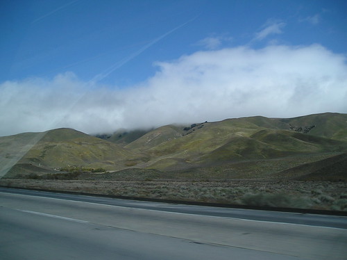
(above - approaching the Tejon Pass from the south. Clouds banked up against the mountains in winter sometimes warn of a localized blizzard just around the corner)
A lot of people funnel through this pass every year, and the passage isn't easy. The wide Central Valley to the north creates a giant funnel, channeling not only travelers, but also north winds, straight into the pass. Winds near hurricane force are not uncommon in the winter. Clouds often form as the air rises over the pass, creating dense fog. Worst of all, because the pass captures winds and moisture from the colder north, blizzards often rage on the north side of the pass, even when Los Angeles, 50 miles to the south, is sunny and warm. Meanwhile, in the summer, dry heat from the Mojave Desert and Central Valley build in, leading to temperatures well over 100 degrees, and dozens of overheating cars on any summer day. Because of the unique climate, blue oaks and buckeye trees normally found further north grow on the north side of the pass, while a few miles to the south Joshua trees are clumped in the gullies. It is a place of convergence, but not a gentle place. Even today, passing through The Grapevine can be treacherous, and the pass is known for its road closures and chain-reaction accidents.
The pass is a prominent and important place, and in 1991, two artists - Christo and Jeanne-Claude - decided to fill the pass with giant umbrellas as part of a giant art exhibit. The effect was visually fascinating, but I can't help but speculate that if the artists thought this was a good idea, they had never tried to drive through this pass during a winter storm. Sure enough, by late October a windstorm swept into the area. One of the umbrellas was ripped from the ground and tossed at several people looking at the art exhibit... and a woman was crushed and killed by the umbrella.
Christo is now planning to stretch 7 miles of fabric over the Arkansas River in Colorado.
(above - approaching the Tejon Pass from the south. Clouds banked up against the mountains in winter sometimes warn of a localized blizzard just around the corner)
Friday, November 11, 2011
It's Time To Wear Orange! (Deer Hunting and Slow Water)
In many parts of the country, different seasons brings different fashion styles. While I was never very good at figuring out how these work in the city, there is one 'fashion season' in rural parts of the country that is very important, if a bit silly looking.
That's right - it's that time of year where most people outside in Vermont are going to start wearing clothes that are brighter orange than the few maple leaves still clinging to the trees. Rifle season for deer hunting starts tomorrow. Most people heading out into the woods wear a bright orange hat and/or vest, so they aren't accidentally mistaken for a deer. If you're heading out for the next few weeks, you should wear a silly orange hat, too. The last day of rifle season in Vermont is November 27th. Muzzleloader season in Vermont is December 3 - 11. Because these guns have a much shorter range than rifles, mistaken identity issues are less likely, but it's still a good idea to wear orange just in case.
Each state has a somewhat different hunting season, so check with your local fish and wildlife department for more info, if you don't already know.

See below for more thoughts on deer hunting and watershed health.
That's right - it's that time of year where most people outside in Vermont are going to start wearing clothes that are brighter orange than the few maple leaves still clinging to the trees. Rifle season for deer hunting starts tomorrow. Most people heading out into the woods wear a bright orange hat and/or vest, so they aren't accidentally mistaken for a deer. If you're heading out for the next few weeks, you should wear a silly orange hat, too. The last day of rifle season in Vermont is November 27th. Muzzleloader season in Vermont is December 3 - 11. Because these guns have a much shorter range than rifles, mistaken identity issues are less likely, but it's still a good idea to wear orange just in case.
Each state has a somewhat different hunting season, so check with your local fish and wildlife department for more info, if you don't already know.
See below for more thoughts on deer hunting and watershed health.
Wednesday, November 9, 2011
Vermont Updates: Middlebury River Management Planning Task Force; Lake Champlain Meetings
At last night's Town of Middlebury Select Board meeting (which I did not attend this time), plans were laid out to create a task force to deal with river and flooding issues in East Middlebury. From the text of the Selectboard Meeting Highlights:
Middlebury River Management Planning Task Force to be Formed. Following the model of the successful river management planning effort in Ripton, the Board endorsed forming a Task Force to develop a plan for on-going management of the Middlebury River as it flows through East Middlebury.
The specialized, focused group could include representatives from the Agency of Natural Resources, the Planning Commission, the Addison County Regional Planning Commission and a river scientist in an effort led by the Town Manager, with technical experts, including engineers with river science experience and hydrologists, retained as needed. The Board emphasized the need to engage residents of East Middlebury in the process by keeping them informed of the group's efforts and soliciting input during the process.
The river management plan is one component of a Hazard Mitigation Plan. The mitigation plan is a pre-requisite for Federal Emergency Management Hazard Mitigation funding, which is the leading source of funding to implement measures to reduce flood hazards.
Town Manager Bill Finger will meet with East Middlebury resident and river scientist Amy Sheldon to develop a strategy for moving ahead with the Task Force and seeking funding for the planning initiative. Pending negotiation of a scope of work, Amy will be retained on a professional basis to serve as the project manager for the effort.
I hope to be involved, at least as a resident of East Middlebury... and also plan to post updates on this blog, which hopefully will provide a balanced, layperson-focused view on what is happening along the river. In general, I think this is excellent news, and I hope this ends up as an entire-watershed effort and includes working with people in Ripton upstream. It's great that Amy Sheldon is involved as she is both a resident and a great river scientist...
The rest of the highlights from the meeting should be posted here soon.
In other Vermont water news, the Poultney Mettowee Natural Resources Conservation District will be holding public meetings about Lake Champlain on November 17th to discuss issues with phosphorous pollution in the lake, and EPA requirements (apparently they have rejected Vermont's current plan). For more info, see here.
Monday, November 7, 2011
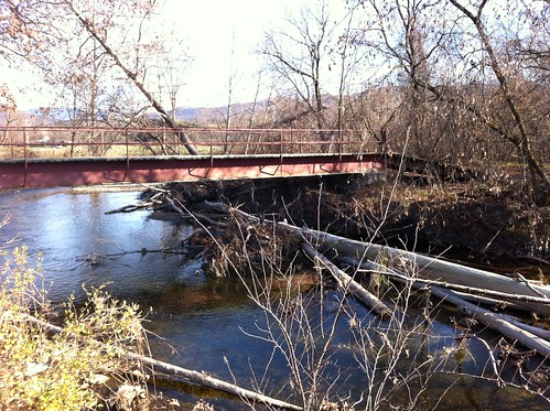
Downed Trees in the River: Burden or Benefit?
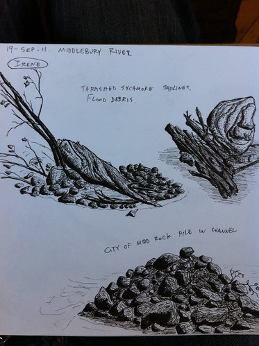
When Irene came raging through Vermont, a lot of trees met their demise. Some of them were done in by wind, which was fairly strong in some places, but many more were sucked into raging rivers and tossed into matchstick-like piles on sandbars.
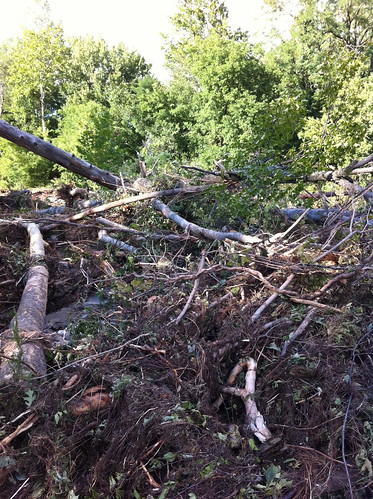
Scenes like the one above are now common in Vermont, and are particularly common along the Middlebury River near where I live. Some are glad to see the logs in the river - they can provide habitat for various animals, including trout and the species they eat. Others are concerned that the logs in the river could cause future problems - causing ice jams or collecting under bridges and causing washouts.
So, who's 'right'?
Thursday, November 3, 2011
Stories Told by the First Snow
Last weekend East Middlebury picked up its first snow - about an inch, but a few miles north it was a dusting and to the south an unseasonable nor'easter raged. We happened to be just on the edge of the storm.
The light early snow settled on the town and the woods, providing a temporary preview of winter months to come. In a few hours, most of the snow had melted. Between the storm's end and the emergence of the sun, however, the snow sat in place for a couple of hours, slowly melting and dripping down from the trees. At this time, the early season snow told me a lot about how the earth holds the summer's heat long after it is gone from the air.
The light early snow settled on the town and the woods, providing a temporary preview of winter months to come. In a few hours, most of the snow had melted. Between the storm's end and the emergence of the sun, however, the snow sat in place for a couple of hours, slowly melting and dripping down from the trees. At this time, the early season snow told me a lot about how the earth holds the summer's heat long after it is gone from the air.
Monday, October 31, 2011
Environmental Action 2011 in Vermont; Thoughts on Gravel Mining in Rivers
As briefly mentioned last week, I was invited to be on a panel at the Environmental Action Conference in Randolph, Vermont last Saturday. The panel was about river repairs in Vermont after hurricane Irene, and the problems associated with removal of gravel and other sediment from waterways. The other people on this panel were Louis Porter of the Conservation Law Foundation and Kim Greenwood of the Vermont National Resources Council.
The session seemed very short, but I did get to show my video demonstrating the perils of improperly channelized rivers, which was a big hit. There was time for some good conversation. In particular, one person wondered whether it were possible to continue 'sustainable' gravel mining at a modest level, similar to what has been done in the past. I find the idea intriguing, but am very skeptical that it is a good idea. Unlike the trees in a well-managed woodlot, gravel in a river is not 'growing' in place, but rather is moving downstream during floods. Removing gravel from one spot can lead to erosion both upstream and downstream, and if gravel removal destroys a house or causes rampant erosion, I would not classify it as sustainable. There were cases after Irene where sediment was removed to protect structures as a lesser of two evils, but there were also cases where overzealous river work may have actually increased future flood risk. Now that the storm is gone we need to think long and hard about our next steps.
The idea that gravel mining can reduce flood risk is widespread in the minds of old-time Vermonters, and while I think the balance of evidence leans strongly towards not removing gravel from rivers, there is a lot of validity to the concern that some rivers in Vermont are building up increasing amounts of sediment. Vermonters know their rivers, and if they notice changes, policymakers should spend the time to listen (as many have). Excessive sediment in Vermont rivers is almost always linked to problems in the upper watershed. Improperly built roads channel and speed up water, and small, improperly placed culverts concentrate water and can wash out, leading to massive amounts of erosion. As many rural areas of Vermont become more populated, and long driveways are built across hillsides, many problems are appearing downstream. Digging gravel out of a river, however, is the hydrologic equivalent of running into a house fully engulfed in flame and tossing burning wood out of the house - towards other homes. Anyone who's ever dug a hole in saturated sand can tell you that the hole quickly caves in, and the same happens with river channels cut into gravel or sand. The real solution is in addressing the 'root' of the problem. What we need to see is more watershed associations, more awareness in upstream residents, and accountability if someone upstream is causing harm to someone downstream.
Also important: policymakers are quick to explain why gravel mining is a bad idea, and very willing to use the legal structure to enforce that gravel mining doesn't occur. What I'd like to see more of is people demonstrating WHY gravel mining is a bad idea. Most people don't want to hurt others, and won't do something willingly that will endanger someone else... but people are also skeptical of outsiders telling them that their well-established actions are wrong. I'd like to see more outreach about the issue in Vermont and other areas, and more honest and open dialog. It's also important to recognizes that there are exceptions to every rule, especially in the case of rivers, and that there were cases after Irene where gravel really did need to be removed from a river.
So, in short, the conference reinforced my belief that efforts to share information with the general public, such as this blog, are important.
To those people who attended the conference and the session (and the later session about the health of Lake Champlain), thanks so much for attending, participating, listening, and sharing your ideas! I enjoyed meeting a lot of neat people, and hope to see many of you around Vermont in the future. I was sad to miss the last part of the conference, but I was quite nervous about driving over two passes on storm-damaged roads in the snow. Thankfully, I made it home before the storm. East Middlebury, by the way, only picked up an inch or two of snow.
Friday, October 28, 2011
Major Early Season Snowstorm in Northeastern US?
My most recent Addison County Independent weather blog post was about the computer models used to create weather forecasts, and about how they often were the cause of 'busted' forecasts or last-minute forecast changes. Specifically, early-week forecasts called for snow in Addison County last night, but by midweek the snow was removed from the forecast in most areas. In the end, the truth fell somewhere between these two forecast extremes - snow fell in my location but did not 'stick' except on a few especially cold surfaces like the tops of cars and dry logs. In the mountains, and to the south in Rutland County, more substantial snow fell - several inches in some places.
Above: light snow accumulation on some stacked wood in East Middlebury. For the most part, no measurable snow fell here.
Above: light snow accumulation on some stacked wood in East Middlebury. For the most part, no measurable snow fell here.
Thursday, October 27, 2011
Plants: Nature's Riverbank Stabilizers
Last week I wrote a post speculating about possible effects of autumn leaves on the flow of rivers and streams. I noticed that the leaves were forming small dams in slow water and decreasing flow rate, but that during a flood, the leaves would quickly be washed away. Since that time, I have come across some new research on much more profound effects that trees and other plants have on rivers. Recent evidence suggests that plants offer much more than just a minor role in affecting river flow. In fact, when plants like ferns, trees, and grasses colonized the land many millions of years ago, they changed the very nature of how rivers flow.
Monday, October 24, 2011
A Few Fall Slow Water Updates: Cold Weather and River Discussion
October has been warmer than average in Vermont so far, but the month is going to leave us with a chill. Later this week a cold storm will come blasting through Vermont, and as it leaves the state it may blast us with some snow - one or two slushy inches in the lowlands, several inches in the mountains. Light snow is not all that unusual for late October, but because it has been warmer than average, it will seem like an abrupt change. One way or another, the storm will usher us into a time known by some as 'stick season'... once the light snow melts away, the trees will mostly be left bare, a forest of sticks over a layer of leaves, with the only color in the woods provided by the bright orange worn to prevent humans and dogs from being mistaken for deer during hunting season.
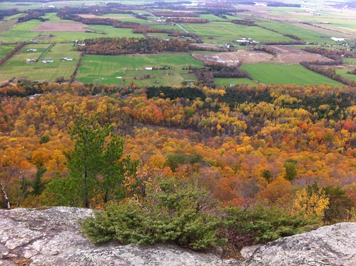
Above: This late October color, as seen from Snake Mountain near Virgennes, will soon be stripped from the trees by wind or wet snow.
Speaking of weather, I've been invited to write occasional blog posts about Addison County's weather for the Addison County Independent online page. You can see my posts here.
I also may be on a panel at the Environmental Action 2011 conference in Randolph, VT this Saturday. I'd be discussing issues associated with gravel removal from rivers and post-Irene flood repairs, along with Kim Greenwood of VNRC and Louis Porter, the Lake Champlain Lakekeeper. I hope to have some discussion about how channelization and dredging of rivers is not only an environmental issue but also a threat to safety and a cause of increased flooding in the long term. I may also talk a bit about my experiences during Irene. I was very lucky, unlike many others in Vermont, in that I did not experience property damage... but I still experienced a very discomforting afternoon and night where I had to leave our home without warning, and spent time in a shelter wondering if our home was damaged or destroyed. After returning home, I experienced quite a bit of concern when a knee-jerk river channelization effort possibly increased the risk of flood wall failure near my home (the flood wall has since been fixed, but significant issues remain and are undergoing long-term community discussion). In any event, if you're at the conference, come by - see here for more info.
Monday, October 17, 2011
Autumn on the Middlebury River - Leaves in the Water
Autumn has come to Addison County. Many of the trees along the Middlebury River are covered in colorful leaves.
Some of the leaves find their way into the river, where they float downstream, occasionally finding themselves clogged in 'leaf jams'. I found myself wondering if this has an effect on water flow.
Some of the leaves find their way into the river, where they float downstream, occasionally finding themselves clogged in 'leaf jams'. I found myself wondering if this has an effect on water flow.
Wednesday, October 12, 2011
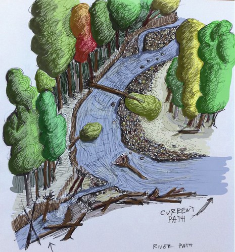
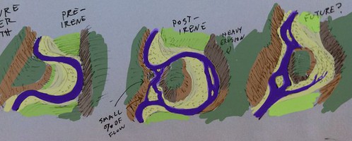
An Illustrated Story of an Oxbow Cut
In the weeks since East Middlebury experienced flooding caused by Tropical Storm Irene, I've been watching a geologic and hydrologic event in progress on the Middlebury River.
When rivers flow through relatively flat areas, they tend to meander. Meanders grow in size as the river erodes away the 'outside' part of the bend (the side that momentum directs the water towards) and deposits sediment on the 'inside' part of the bend. Over time, the meanders become more and more convoluted, until the meander grows so large that it cuts back towards itself. The river then shifts course to 'cut off' the majority of the meander, often leaving a lake or wetland in the abandoned river channel.
The meanders are called oxbows, and are commonly found on natural, slow-moving watercourses of all sorts. There is a good description of the process here on Wikipedia.
Below is a Google aerial photo of part of the Middlebury River (not the part I have photos and drawings of, but in this area it is easier to make out the river bends).
View Larger Map
You can see many bends including one that has recently cut off, which is at lower right.
With the bend near my home, Irene was able to ALMOST cut through the bend, but didn't quite finish the job. On the upstream side, the bend cut towards west, and on the downstream side of the bend erosion from water that spilled over the flood plain began eroding backwards and creating a new channel. The result was a small new branch of the river that cuts across the 'neck' of the bend, with a deep pool in its upstream portion, and a chunk of dirt about 30 feet long that keeps the main force of the river out of its potential new channel... for now.
Below is a sketch I made to illustrate the current status of the cut. The river flows from the background and bends towards the right, and on the lower left you can see the new river path forming.
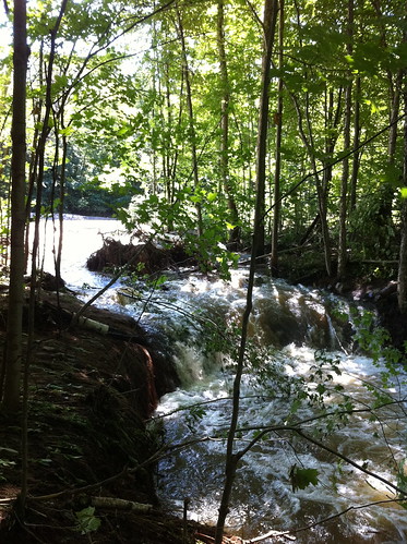
Here's a photo of the new channel, taken when the river was still running very high after Irene:
After several dry days, the water has dropped a lot in the river, but even when the river is low there is a small amount of flow in the channel:
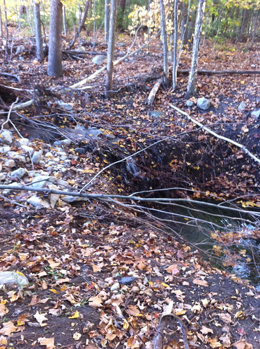
Notice all the tree roots in the eroding area. They are doing an excellent job of holding the soil in place, and since the river has not risen much since Irene, very little additional erosion has occurred here. I think it will be surprisingly resilient to erosion, but I think the next big flush of water (perhaps the spring thaw) will probably cause most or all of the river to divert down this path.
See here for an album of photos. I'll be adding more over time.
Here's an illustrated overview of the oxbow cut:
Here are two more sketches from that day:
I'll keep watching the oxbow. Hopefully I can catch it right after it breaks and get good photos of the river in action! Further forward in time, the abandoned stretch of river will turn into floodplain forest, and will continue to absorb and slow down floodwaters and act as a filter to remove sediment from the river.
Subscribe to:
Posts (Atom)