Tuesday, June 28, 2011

Eau Lente à Montréal, Québec (Slow Water in Montreal, Quebec)

(Note that I used Google Translator for the title, if it looks wrong, let me know and I'll fix it).

I've been spending quite a bit of time in Quebec lately.  Last weekend I was in Montreal for the Jazz Fest, but of course I was looking around at urban water features as well.

IMG_2888.JPG

Friday, June 24, 2011

Fun with QR Codes

It's been rainy and wet out, so after walking around in the rain a bit, I decided to come in and play around with some technology.

My friend just got back from New York City, and mentioned that the prevalence of QR codes has recently increased drastically.  These codes, in the form of squares embedded with a variety of large pixels, can be used to encode URLs, text, and other information.  They are most often used for marketing but are occasionally being used for outreach as well.  The larger scale potential for use of QR codes is huge, although I think for the time being they will continue to mainly be used in marketing and advertising.  I am thinking of putting up some QR codes for some of the urban hydrology features in Burlington after UVM fills with students again next fall, to see if anyone scans them.

I remembered reading somewhere that QR codes are not color sensitive.  So, I decided to fiddle with the QR code a bit and see how much I could change it while retaining the link.

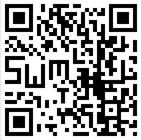
Here's the initial Slow Water Movement QR code:

Slow Water 1

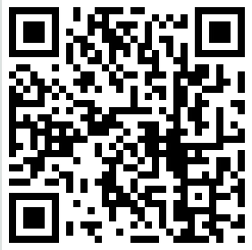
I tried adding a bit of color... and it still worked.

Slow Water 2

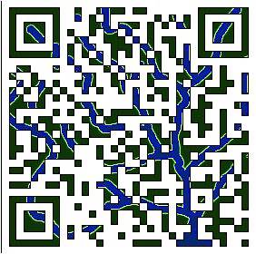
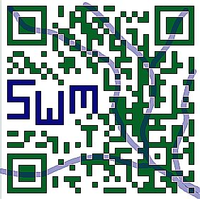
Next, I tried moving a few of the pixels to create letters.  Oddly, this still scans to the Slow Water Movement site:

Slow Water 3

Then I tried adding color to this version, including some subtle colors in the background:

Slow Water 4

I tried one more with more exaggerated colors, but it didn't work.  This last one was the most modified one I was able to create that still linked to this blog.

Does it work on your phone?  It may be that different phones have differing abilities to read QR codes.  I have an Iphone 4.

Based on the wikipedia article I linked above, I am far from the first person to come up with this idea.  Different forms of QR codes have been embedded in a wide variety of artistic endeavors.

Anyone else want to try making a fancy new Slow Water Movement QR code?  Give it a try and if it works, I'll post it here too.

Saturday, June 18, 2011

Sterling Pond, Part II

This will be a short post, because we're enjoying these warm early summer days.

Upon visiting Sterling Pond, we were able to find a series of trails that went around the lake.  The far side of the lake is beautiful, especially since the person rudely playing music on a boombox at the other side of the lake was not audible there.

IMG_2635.JPG

The second pond outlet was a bit of a disappointment.  There was no water flowing south!  Instead, there was a bit of a boggy area, and no sign of recent water flow.  Most likely there is flow to the south during snowmelt, which comes rather late to Sterling Pond, which is in a very cold place.

About the water found in the outlet... it too reflected the cold climate of the area.  Rather than a creek, there was a small patch of snow in the shaded outlet area, despite it having been quite warm lately.

IMG_2636.JPG

We also found talc deposits on the far side of the lake, reinforcing the idea that the lake is there because very soft rock was eaten away by the glaciers.

So... Sterling Pond is rarely, if ever, in the Winooski watershed.  The Lamoille outlet area is heavily trampled, and I can't help but wonder if heavy foot traffic in this sensitive area has lowered the level of this outlet a few inches, tipping the very delicate balance of this lake and ending the flow of the Winooski outlet.

Another reminder... wetlands are fragile, so explore them gently or keep to the uplands.

Monday, June 13, 2011

Return to Sterling Pond (cliffhanger)

Last week I made a return visit to Sterling Pond with two friends.  Our goal?  To find out if the pond really drains into both the Winooski and Lamoille watersheds.

Sterling pond is right on the divide of the Green Mountains, so it is a bit of a steep hike up, though beautiful.

IMG_2625.JPG

We already knew about the first outlet - the one that drains into the Lamoille River...  IMG_2627.JPG

and beyond, via Jeffersonville, to the Lamoille river.

IMG_2629.JPG
(seen above is Jeffersonville from Smuggler's Notch Ski Resort.  The dry, rocky area in the foreground is not the creek)

But what of the second outlet?  Was there water flowing north to the Winooski river at the same time?

Well.. we did manage to circumnavigate the lake, and we did find water at the second outlet location... but not exactly the kind of water we expected...

Check back here at the end of the week to see what we found!

Thursday, June 9, 2011

More Storms in Vermont

After more record heat, Vermont is experiencing more thunderstorms.  The current wave of storms is not producing as much heavy rain so far, because the storms are moving quickly and because the ground is not nearly as saturated as the last round of storms.  However, there still have been some severe storms with gusty winds, frequent lightning, hail, and the other things that come along with severe weather.

Picture 4

Monday, June 6, 2011

Vegetation Mapping... looking back

It is interesting how water is a model for how so much of the world works.  Time is often compared to a river, always flowing forwards... we are present in only one part of this river, with only eddies to remind us of the past, and very little indication of what is beyond the immediate future.  Sometimes, though, the river of time makes vast loops, and by peeking over the oxbow we are able to remember a bit of what our lives were like, many years before.

vegmap

Something like this happened today.  I stumbled across something on the internet that I helped make quite some time ago.  Before the sudden, abrupt shift in my life that led me off my previous course and to Vermont to attend grad school... I had been on a relatively set course for a long time.  I was a vegetation mapper.


Friday, June 3, 2011

In western Vermont? Help track invasive species!

This spring I've been helping test out 'What's Invasive', an Android and Iphone app designed to map invasive species in the field.  I created a 'Park' for Vermont called "Champlain Valley of Vermont" and added several invasive species that I think are worth tracking.

The program is free, fun, and easy!  All you do is load it on your gps-enabled smartphone (it won't work on non-gps phones)... create a free account, log into the Champlain Valley park, and start reporting weeds when you see them.  For buckthorn and honeysuckle, the app required me to choose just one species, but please do map any invasive buckthorn or honeysuck under these categories.  Also, if you aren't in the Champlain Valley, but still want to test this out, that is fine too.

I've got quite a head start on sightings, but if anyone can get more (legitimate!) sightings than me before winter, I will draw you a picture of an invasive plant of your choice, in this style:

Crocus

They have to be spread out at least a little... please don't photograph every stem in a garlic mustard clump :)

Also if you have any ideas about how to make the app better, let me know and I will pass those along to the app designers.  Or, email them yourself from the What's Invasive website.